• There seems to be an uptick in Political comments in recent months. Those of us who are long time members of the site know that Political and Religious content has been banned for years. Nothing has changed. Please leave all political and religious comments out of the forums.

    If you recently joined the forums you were not presented with this restriction in the terms of service. This was due to a conversion error when we went from vBulletin to Xenforo. We have updated our terms of service to reflect these corrections.

    Please note any post refering to a politician will be considered political even if it is intended to be humor. Our experience is these topics have a way of dividing the forums and causing deep resentment among members. It is a poison to the community. We appreciate compliance with the rules.

    The Staff of SOH

  • Server side Maintenance is done. We still have an update to the forum software to run but that one will have to wait for a better time.

Chart VORTAC spec explanation request

manfredc3

SOH-CM-2022
Hello,

On one of the charts I pulled recently, it shows a L and H value under the VORTAC specs.

I have searched all over the place, and have not been able to find an explanation of the meaning of these indicators.

attachment.php


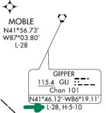
The VORTAC is showing on the KORD O'Hare EIGHT DEPARTURE chart.

Can anyone shine a light on this for me, please.
 

Attachments

  • VORTAC (2)_LI.jpg
    VORTAC (2)_LI.jpg
    73.6 KB · Views: 0
It is saying you can see the VORTAC on the Low Altitude (Victor Airways) L-28, and High Altitude H-5 and H-10 (Jet Route) IFR airways charts. The "Channel" is used by the military for UHF TACAN. TACAN looks and acts like a VOR with DME, but you dial in a channel vice a frequency. TACAN in the UHF spectrum allows independent military stations where necessary - it is also relatively "mobile" and can be set up at expeditionary locations quickly if needed. A VORTAC means it is a co-located VOR and TACAN station.
 
Those numbers refer to the NOS enroute charts the GIJ VOR is found: Low Chart 28 or High Charts 5 or 10. Head over to www.skyvector.com and search for the GIJ VOR. At the top right corner of the map, you'll see several different chart selections, including Enroute H-10, Enroute H-5, and Enroute L-28.

There's lots of NOS enroute charts covering the United States (36 Low and 12 High, IIRC). Referencing the chart number on the SID makes it easier for a pilot to find the correct enroute chart.


[Edit: Whoops! Don't know why Mike71s post didn't show up for me until after I posted. Oh well. Sorry for the repeat!]
 
Last edited:
Those numbers refer to the NOS enroute charts the GIJ VOR is found: Low Chart 28 or High Charts 5 or 10. Head over to www.skyvector.com and search for the GIJ VOR. At the top right corner of the map, you'll see several different chart selections, including Enroute H-10, Enroute H-5, and Enroute L-28.

There's lots of NOS enroute charts covering the United States (36 Low and 12 High, IIRC). Referencing the chart number on the SID makes it easier for a pilot to find the correct enroute chart.


[Edit: Whoops! Don't know why Mike71s post didn't show up for me until after I posted. Oh well. Sorry for the repeat!]

No problem - and I completely agree with your input regarding skyvector -a fantastic resource and excellent way to plan a flight. However, many advanced features are kind of a hidden secret, though I have not really read through all the supporting forum material
 
There's quite a few things I learned about skyvector by reading their documentation. It's really quite useful!

A long time back I figured out a way to use skyvector as sort of a "plotting board" for long, overwater flights. With only the website and my trusty old Jeppesen CR-5 or E6B, I was able to routinely navigate to far off islands in the Pacific in my Super Connie. That was really fun, since I like a good mental exercise every now and then!
 
MIke71 and nagpaw,

Thank you both very much for your info.

And nagpaw, no need to say sorry, It is highly appreciated when people are willing to share their knowledge. It is what makes this community so special.

I use Skyvector,com for most of my flights, but never took the time to read their documentation.

I did look everywhere I knew for the answer to my original question, and just had no luck.
For one, I will certainly be spending some time reading the documentation on Skyvector.com.

I still use my trusted E6B when flying old props, like the graceful DC-2 and DC-3.

Again, thank you both for your reply.
 
Back
Top