FlameOut
SOH-CM-2025
Hi all,
I was surprised with WU X that Asobo updated the model of the USS ALABAMA (BB-60) and put it on the POI (points of interest). Why? Proof of concept or design? What does this have to do with a flying sim? Another thing is who wants to come to Alabama?
Well, I do, I live here and I'm proud and have misgivings about some facts of our state's history. That is another discussion entirely. Moving on.
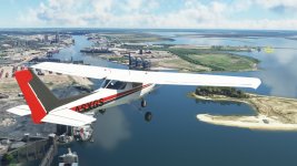
I started my flight from KBFM and headed out into Mobile Bay, flew past our ports and over to where she is berthed. Look for the yellow arrow.
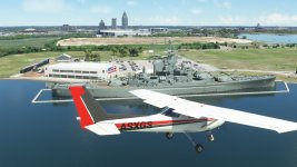
Now that is much better!
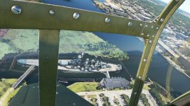
This is how she looked in Sept. 2020, a post-apocalyptic nuclear war melt down
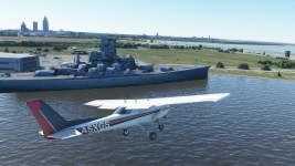
The point of this post is that it got me thinking about all of the other Battleships depicted in MSFS. Who says you cannot learn something from MSFS and have a blast while doing it.
Make sure you go to Assistant options and tick on the POI option.
Here is the list of the battleships that are afloat:
NEW YORK-class USS TEXAS (BB-35)[WWI ERA BATTLESHIP] SAN JACINTO,TEXAS ... search POI for San Jacinto monument unless you live in the area and know of it well.
NORTH CAROLINA-class USS NORTH CAROLINA (BB-55) WILLMINGTON,NORTH CAROLINA
SOUTH DAKOTA-class USS MASSACHUSETTS (BB-59) FALL RIVER,MASSACHUSETTS, USS ALABAMA (BB-60) MOBILE,ALABAMA
IOWA-class USS IOWA (BB-61) PORT OF LOS ANGELES,CALIFORNIA, USS NEW JERSEY (BB-62) CAMDEN,NEW JERSEY, USS MISSOURI (BB-63) PEARL HARBOR,HAWAII, USS WISCONSIN (BB-64) NORFOLK, VIRGINIA
I hope I got those correct.
I just started using MSFS default flight planning map and went to those cities and started searching the harbors by zooming down to cities as close as I could get and scrolling around. I would then click on the map to create a custom point of navigation and fly from there.
Those of you not familiar with US cities here is a list of local airports you can fly out of.
BB-35 SAN JACINTO search in POI
BB-55 Wilmington KILM
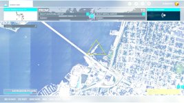
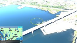
BB-59 Massachusetts KEWB totally sunken no 3D model at all, I'll interrupt here with screenshots from the flight planning map and an in game screenshot. Sorry for the overexposure HDR10 is turned on.
BB-60 Mobile, Alabama, KBFM
BB-61 Port of Los Angeles,California KTOA rwy11R or 11L ....... KLGB rwy 26R or 26L then turn left ........ KSLI 22R or 22L turn right about 240*
BB-62 Camden,New Jersy across from KPHL turn left and go upriver towards downtown Philly(Philadelphia, Pennsylvania) past 1st. bridge but do not pass 2nd bridge
BB-63 NPS Ford Island NALF totally sunken no 3D model at all
BB-64 Norfolk KORF rwy 23 turn right hidden very well( this one is going to take you all day to find)
You can find all of the Battleships in MSFS. All of them have 3d models in various states of deterioration. The BB-59 Massachusetts and BB-63 Missouri have no 3d model.
Anyways, some fun facts about Mobile Bay:
1. not counting low and high tides the average depth Mobile Bay is just 3 meters with the shipping channels up to 24 meters( assuming dredging of channels is maintained)
2. "Damn the torpedoes, full speed ahead" supposedly uttered by Rear Admiral David G. Farragut of the Union fleet on August 5, 1864 during the Battle of Mobile Bay.
Fort Morgan is on the Eastern shore at the entrance into Mobile Bay, look for it. It is built in the typical 5-point star layout of Civil War coastal forts.
3. Fatalities and losses: Union forces: 1 ironclad, 151 KIA, 177 wounded. Confederate forces: 1 ironclad, 2 gunboats, 13KIA, 22 wounded. When Fort Morgan surrendered 1,500 men captured
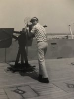
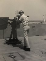
Closing out the post, here's a picture of my older brother on the USS Alabama around 1965-1966. My twin brother and I were there also but I've lost those photos. We were prolly about 7yo.
I was surprised with WU X that Asobo updated the model of the USS ALABAMA (BB-60) and put it on the POI (points of interest). Why? Proof of concept or design? What does this have to do with a flying sim? Another thing is who wants to come to Alabama?
Well, I do, I live here and I'm proud and have misgivings about some facts of our state's history. That is another discussion entirely. Moving on.
I started my flight from KBFM and headed out into Mobile Bay, flew past our ports and over to where she is berthed. Look for the yellow arrow.


Now that is much better!
This is how she looked in Sept. 2020, a post-apocalyptic nuclear war melt down

The point of this post is that it got me thinking about all of the other Battleships depicted in MSFS. Who says you cannot learn something from MSFS and have a blast while doing it.
Make sure you go to Assistant options and tick on the POI option.
Here is the list of the battleships that are afloat:
NEW YORK-class USS TEXAS (BB-35)[WWI ERA BATTLESHIP] SAN JACINTO,TEXAS ... search POI for San Jacinto monument unless you live in the area and know of it well.
NORTH CAROLINA-class USS NORTH CAROLINA (BB-55) WILLMINGTON,NORTH CAROLINA
SOUTH DAKOTA-class USS MASSACHUSETTS (BB-59) FALL RIVER,MASSACHUSETTS, USS ALABAMA (BB-60) MOBILE,ALABAMA
IOWA-class USS IOWA (BB-61) PORT OF LOS ANGELES,CALIFORNIA, USS NEW JERSEY (BB-62) CAMDEN,NEW JERSEY, USS MISSOURI (BB-63) PEARL HARBOR,HAWAII, USS WISCONSIN (BB-64) NORFOLK, VIRGINIA
I hope I got those correct.
I just started using MSFS default flight planning map and went to those cities and started searching the harbors by zooming down to cities as close as I could get and scrolling around. I would then click on the map to create a custom point of navigation and fly from there.
Those of you not familiar with US cities here is a list of local airports you can fly out of.
BB-35 SAN JACINTO search in POI
BB-55 Wilmington KILM
BB-59 Massachusetts KEWB totally sunken no 3D model at all, I'll interrupt here with screenshots from the flight planning map and an in game screenshot. Sorry for the overexposure HDR10 is turned on.


BB-60 Mobile, Alabama, KBFM
BB-61 Port of Los Angeles,California KTOA rwy11R or 11L ....... KLGB rwy 26R or 26L then turn left ........ KSLI 22R or 22L turn right about 240*
BB-62 Camden,New Jersy across from KPHL turn left and go upriver towards downtown Philly(Philadelphia, Pennsylvania) past 1st. bridge but do not pass 2nd bridge
BB-63 NPS Ford Island NALF totally sunken no 3D model at all
BB-64 Norfolk KORF rwy 23 turn right hidden very well( this one is going to take you all day to find)
You can find all of the Battleships in MSFS. All of them have 3d models in various states of deterioration. The BB-59 Massachusetts and BB-63 Missouri have no 3d model.
Anyways, some fun facts about Mobile Bay:
1. not counting low and high tides the average depth Mobile Bay is just 3 meters with the shipping channels up to 24 meters( assuming dredging of channels is maintained)
2. "Damn the torpedoes, full speed ahead" supposedly uttered by Rear Admiral David G. Farragut of the Union fleet on August 5, 1864 during the Battle of Mobile Bay.
Fort Morgan is on the Eastern shore at the entrance into Mobile Bay, look for it. It is built in the typical 5-point star layout of Civil War coastal forts.
3. Fatalities and losses: Union forces: 1 ironclad, 151 KIA, 177 wounded. Confederate forces: 1 ironclad, 2 gunboats, 13KIA, 22 wounded. When Fort Morgan surrendered 1,500 men captured
Closing out the post, here's a picture of my older brother on the USS Alabama around 1965-1966. My twin brother and I were there also but I've lost those photos. We were prolly about 7yo.


