-
Please see the most recent updates in the "Where did the .com name go?" thread. Posts number 16 and 17.
You are using an out of date browser. It may not display this or other websites correctly.
You should upgrade or use an alternative browser.
You should upgrade or use an alternative browser.
CFS3 Terrian Creation _part II
- Thread starter NachtPiloten
- Start date
 for his friendly ear. Now to shorelines and then textures. Long way to go but dam!!
 3arc SRMT files....
Thanks
Just need to learn how to place the correct scenery texture files. I have a vector tutorial (maybe yours) but placing textures and trees etc. will be the most time consuming and unknown....
Just need to learn how to place the correct scenery texture files. I have a vector tutorial (maybe yours) but placing textures and trees etc. will be the most time consuming and unknown....
Theaters
I want to model two areas of interest. First being the Battle for the Bay of Biscay. This necessitates moving west a fair amount. I also chose this since I can use (hopefully) the global layer just eliminating all entries further east than what the theater requires. There will be a lot of water so this makes it a bit easier too (maybe). I can use some of the landclass data from the original CFS3 models and learn the way all this works. Once that is done then we go north to the North Sea northwest of Norway. But I am still wanting to complete TOW first and foremost...just waiting for the paint to dry.
I want to model two areas of interest. First being the Battle for the Bay of Biscay. This necessitates moving west a fair amount. I also chose this since I can use (hopefully) the global layer just eliminating all entries further east than what the theater requires. There will be a lot of water so this makes it a bit easier too (maybe). I can use some of the landclass data from the original CFS3 models and learn the way all this works. Once that is done then we go north to the North Sea northwest of Norway. But I am still wanting to complete TOW first and foremost...just waiting for the paint to dry.
mongoose
SOH-CM-2026
I want to model two areas of interest. First being the Battle for the Bay of Biscay. This necessitates moving west a fair amount. I also chose this since I can use (hopefully) the global layer just eliminating all entries further east than what the theater requires. There will be a lot of water so this makes it a bit easier too (maybe). I can use some of the landclass data from the original CFS3 models and learn the way all this works. Once that is done then we go north to the North Sea northwest of Norway. But I am still wanting to complete TOW first and foremost...just waiting for the paint to dry.
Alles ist klar!
rbp71854
PTO Solomons ,PTO Rising Sun, ETO Expansion
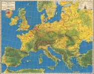
Thought this might be helpful in your theater creations. You will find topos, road maps, and city maps created by US Army, and British War office. Have fun.
[h=2]Perry-Castañeda Library
Map Collection[/h][h=3]Europe Maps[/h]
https://maps.lib.utexas.edu/maps/europe.html#N
[h=2]Perry-Castañeda Library
Map Collection[/h][h=3]Spain Maps[/h]https://maps.lib.utexas.edu/maps/spain.html
[h=2]Perry-Castañeda Library
Map Collection[/h][h=3]Norway Maps[/h]
https://maps.lib.utexas.edu/maps/norway.html
[h=2]Perry-Castañeda Library
Map Collection[/h][h=3]Sweden Maps[/h]
https://maps.lib.utexas.edu/maps/sweden.html
[h=2]Perry-Castañeda Library
Map Collection[/h][h=3]Europe Maps[/h]
https://maps.lib.utexas.edu/maps/europe.html#N
[h=2]Perry-Castañeda Library
Map Collection[/h][h=3]Spain Maps[/h]https://maps.lib.utexas.edu/maps/spain.html
[h=2]Perry-Castañeda Library
Map Collection[/h][h=3]Norway Maps[/h]
https://maps.lib.utexas.edu/maps/norway.html
[h=2]Perry-Castañeda Library
Map Collection[/h][h=3]Sweden Maps[/h]
https://maps.lib.utexas.edu/maps/sweden.html
Those maps and resources!
Geez, thanks a bunch these are too cool. Will be put to good use I hope!
Geez, thanks a bunch these are too cool. Will be put to good use I hope!
rbp71854-Making a tif
The maps that are from the USGS have many colors on them. CFS3 seems to use about 16, do you remember how you converted the USGA maps to CFS3 friendly ones to make the theater tif?
The maps that are from the USGS have many colors on them. CFS3 seems to use about 16, do you remember how you converted the USGA maps to CFS3 friendly ones to make the theater tif?
rbp71854
PTO Solomons ,PTO Rising Sun, ETO Expansion
The maps that are from the USGS have many colors on them. CFS3 seems to use about 16, do you remember how you converted the USGA maps to CFS3 friendly ones to make the theater tif?
I did not get to the point of generating a new landclass for the theaters. I did start creating a lanndclass tiff for the island of Hawaii, but my wrist gave out and had to quit all development work.

I used the topos mostly to create the railroads, roads, harbors, airfields. With GlobalMapper I was able to overlay them on my theaters and generate the vectors and airfields.
ok
Thanks for the ideas. They will help.
Thanks for the ideas. They will help.