I've been going through the myriad of airfield that I have installed in my PTO theater install of CFS2. This uses Rhumba's mesh and water. Many of the airfields I have installed work just fine, but of course not all. Many of Xavier's China, Burma and India fields, as well as his Japanese fields just don't work. Is there a way I can edit their location, or should I just remove them from this install?
You are using an out of date browser. It may not display this or other websites correctly.
You should upgrade or use an alternative browser.
You should upgrade or use an alternative browser.
How do I correct the location of or remove an airfield?
- Thread starter Browncoat
- Start date
Shadow Wolf 07
SOH-CM-2023
Cheers Browncoat:
The easy way to move or delete an airfield is by modifying the Long and Lat info on the airbases.dat file for that entry. The real way is more complicated and can require flattens, compensation for elevation and so forth. You'll need a tutorial for that, probably.
SW07
The easy way to move or delete an airfield is by modifying the Long and Lat info on the airbases.dat file for that entry. The real way is more complicated and can require flattens, compensation for elevation and so forth. You'll need a tutorial for that, probably.
SW07
Hiede
Members +
The Xavier scenery was done 2004-2005 before the Rhumba's mesh was done so the scenery is not setup for it.We use DEM5,7 and 8 and everything works fine.Try deactivating Rhumba's mesh and/or watermasks in the Scenery Library and see how those airfields look.
Hiede
highpockets
SOH-CM-2023
I was reading an account of the 1st Air Commando Group flying p-51A and later P-47d out of Hailakandi, India. that airfield is not in Xavier scenery, but i have located the approximate location latitude and longitude near the existing town . could that be added on the end of the list in the CBI of Talon's AVG , place airfield scenery and fly missions out of it?
Shadow Wolf 07
SOH-CM-2023
Try this old buddy: You can build any base anywhere in the world using Maskrider's tutorial (attached), FSSC (Flight Simulator Scenery Creator}, and a decent paint program like Paint Shop Pro . You'll need the lat and long, elevation and orientation to place your airbase.
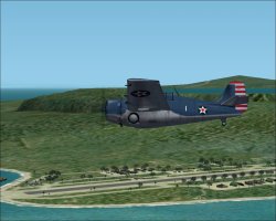
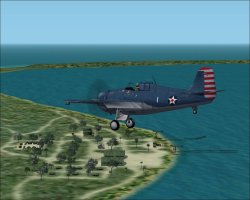
Below are 2 screenshots of my first attempt at base building some 15 years ago. It's really not that difficult
Or... you can hope one of us builds it for you!")
Cheers:
SW07
Below are 2 screenshots of my first attempt at base building some 15 years ago. It's really not that difficult
Or... you can hope one of us builds it for you!
Cheers:
SW07
Attachments
highpockets
SOH-CM-2023
Thanks SW. It may be a bit over my head. I will take a look when my schedule is a little cleaner.
I will have to get the elevation.
I will have to get the elevation.
UncleTgt
SOH-CM-2024
Easiest way to get the elevation -
Start a Free Flight at the coordinates you have for Lat & Long.
Ctrl Z to see the coordinates & altitude.
Note these
Look at the aircraft.cfg of the aircraft you used.
Subtract the c of g height from the altitude you noted & you have your airfield elevation.
Whilst you're standing at the location, just take a good look around, noting the mesh in the surrounding area.
Ask yourself if this " looks right".
Would they build on sloping ground?
Are there obstructions nearby that would make approach & egress "problematic"?
Does the terrain vista look like any photos you might have?
I often find that published location data is somewhat "innacurate", so use aircraft Slew to move around a bit until I'm happy with the location...