txnetcop
Charter Member
New approach-capable GPS navigator in X-Plane 10.30
Posted on March 28, 2014 by Philipp Münzel
X-Plane has been lacking a decent navigation solution for general aviation aircraft for a long time. The built-in GNS430 instrument could only do direct-to navigation and not use X-Plane’s FMS plans, making long IFR flights inconvenient.
In X-Plane 10.30 we are introducing a new generation of the X-Plane 430 GPS navigator, modeled more closely after the Garmin 430W that is very popular in general aviation aircraft. The 430W is a popular aftermarket GPS replacement in many older general aviation aircraft, because it is approved for WAAS approaches and thus an easy upgrade to allow flying instrument approaches at lots of smaller airports without ILS.
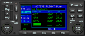
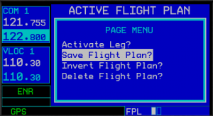
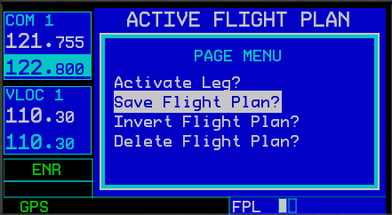
The new X-Plane unit can create and fly multi-leg flightplans in addition to the direct-to function:
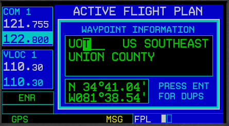
You can create directs or flight plans using a worldwide database of airports, fixes and navaids:

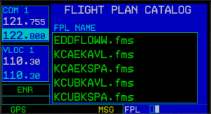
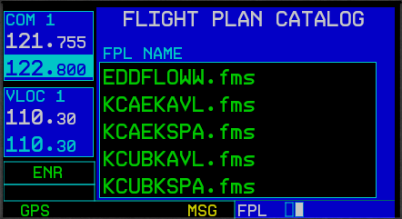
Loading or saving the route works using the X-Plane FMS format. Many online services for virtual flight planning are compatible with that:
You can then navigate along your flight plan using one of different map views that provide situational awareness:
While flying under VFR, stay alert to any Bravo, Charlie, Delta or special use airspace in the United states (open database, user-expandable):
For more information go here: http://developer.x-plane.com/2014/03/new-approach-capable-gps-navigator-in-x-plane-10-30/
Ted
Posted on March 28, 2014 by Philipp Münzel
X-Plane has been lacking a decent navigation solution for general aviation aircraft for a long time. The built-in GNS430 instrument could only do direct-to navigation and not use X-Plane’s FMS plans, making long IFR flights inconvenient.
In X-Plane 10.30 we are introducing a new generation of the X-Plane 430 GPS navigator, modeled more closely after the Garmin 430W that is very popular in general aviation aircraft. The 430W is a popular aftermarket GPS replacement in many older general aviation aircraft, because it is approved for WAAS approaches and thus an easy upgrade to allow flying instrument approaches at lots of smaller airports without ILS.
The new X-Plane unit can create and fly multi-leg flightplans in addition to the direct-to function:

You can create directs or flight plans using a worldwide database of airports, fixes and navaids:
Loading or saving the route works using the X-Plane FMS format. Many online services for virtual flight planning are compatible with that:
You can then navigate along your flight plan using one of different map views that provide situational awareness:
While flying under VFR, stay alert to any Bravo, Charlie, Delta or special use airspace in the United states (open database, user-expandable):
For more information go here: http://developer.x-plane.com/2014/03/new-approach-capable-gps-navigator-in-x-plane-10-30/
Ted