• There seems to be an uptick in Political comments in recent months. Those of us who are long time members of the site know that Political and Religious content has been banned for years. Nothing has changed. Please leave all political and religious comments out of the forums.

    If you recently joined the forums you were not presented with this restriction in the terms of service. This was due to a conversion error when we went from vBulletin to Xenforo. We have updated our terms of service to reflect these corrections.

    Please note any post refering to a politician will be considered political even if it is intended to be humor. Our experience is these topics have a way of dividing the forums and causing deep resentment among members. It is a poison to the community. We appreciate compliance with the rules.

    The Staff of SOH

  • Server side Maintenance is done. We still have an update to the forum software to run but that one will have to wait for a better time.

Strange weather today

robert41

SOH-CM-2016
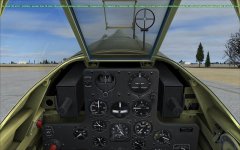
At KATW. Using real weather. A very low pressure reading. So low I could not set the altimeter low enough on several aircraft. Airport elevation is about 900ft.
 

Attachments

  • 2015-10-13_15-54-48-755.jpg
    2015-10-13_15-54-48-755.jpg
    81.8 KB · Views: 4
Looks like the METAR reported for KATW today at 1345Z had erroneous data: KATW 131345Z 29018G23KT 10SM BKN020 09/05 A2062

Edit: How were the flight characteristics for your flight? Given the METAR reported altimeter setting (20.62 inHg), the pressure altitude should've been 9300 ft + field elevation (918 ft at KATW). Did it seem like you were flying at 10,200 ft?
 
Last edited:
Flights characteristics were normal, just the higher altimeter reading. I went up to 3-4000ft from the shift z data. Once close to OSH, the pressure read more normal.

Adding. I took up the A2A182 and did act like being at 4000ft.
 
Erroneous would be a good bet...

"The lowest non-tornadic atmospheric pressure ever measured was 870 hPa (25.69 inHg), set on 12 October 1979, during Typhoon Tip in the western Pacific Ocean."

Now, it's possible there was a tornado over the airport but in that case the winds would be a lot higher than reported, so best guess is a typo in the source report.

The alternative is to set the altimeter to show field elevation for departure and then correct it once information is available.
 
Was unable to set the altimeter any lower on several aircraft. Maybe a gauge limit? Interesting that the shift z data shows the correct altitude. Also the AI had no problems with this.
All back to normal readings today.
 
Back
Top