• Warbirds Library V4 (Resources for now) How to


    We just posted part one of the how to on uploading new files to the Library. Part 1 covers adding new files. Part 2 will cover making changes to your the uploads you own.


    Questions or comments please post them in the regular forums. Which forum is that... Well it is the one you spend the most time in.

    Thanks the Staff

    Library How to

P3D_V4 Tacan v5.0 Question

hardlucksam

Members +
Don't understand how to make the TACAN gauge recognize the Carrier Name?? Can someone *please please* help me. Everything else is correct. Many thanks.
Pict 1.pngPict 2.png
 
Don't understand how to make the TACAN gauge recognize the Carrier Name?? Can someone *please please* help me. Everything else is correct. Many thanks.
View attachment 82733
The gauge will only "find" ships or FCLP listed beginning on page 31 of the user manual (also in the Gauges\RFN_Resources\RFN_Carrier.xml file).
If it isn't listed you can add it by following the instructions beginning on page 22.
Since 114.70 has not been assigned in the RFN_Carriers.xml file you would need to create a new entry.
Then take the TACAN frequency associated with that carrier/FLCP and tune it into the bottom section of the gauge.
Hope this helps.
:ernaehrung004:
 
I should add more after viewing your snippet of code.
It is incomplete. You need to add coordinates for the touchdown zone and the FCLP (if you want to use one).

Something like this below. This will get you aimed at the base within 100 miles and will also get you lined up with Runway 2.
I left off the FCLP but you can see the options for that on page 23 of the manual.
(I'm using default scenery so the old runway 2R isn't there anymore.)

Code:
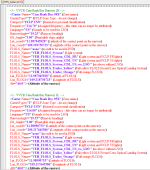
<!-- Cam Ranh Air Base 94X-->	
<Carrier Name="Cam Ranh Air Base"
	CarrierType="2"
	Category="FCLP VN"
	Frequency="114.70"		
	Language="US"
	RunwayAngle="19.70"
	GS_Angle="3.60"
	Lat_coord="11.994444"
	Lon_coord="109.220000"
	FLOLS_Name="none"
	Lat_FLOLS="11.994444"
	Lon_FLOLS="109.220000"
	Alt="46.00"/>

Here is a tool for converting FSX/P3D map coordinates to the decimal format used in the RFN gauge.
https://www.latlong.net/degrees-minutes-seconds-to-decimal-degrees
:ernaehrung004:
 
Mr Safranek, thank you so much for the example. Will give is a try tomorrow. Just to clear airport up > this is what Cam Ranh Bay looked like in 1967-1968. Google Earth shows what it looks like now. Question; are you referring to entering information like this in ADE VOR/DME?? Thank You.
Pict 3.png
 
quote_icon.png
Originally Posted by hardlucksam
Mr Safranek, thank you so much for the example. Will give is a try tomorrow. Just to clear airport up > this is what Cam Ranh Bay looked like in 1967-1968. Google Earth shows what it looks like now. Question; are you referring to entering information like this in ADE VOR/DME?? Thank You.


What you see, its „normal” VOR+DME, gauge works with this but without animation and effect of FCLP. For FCLP you must use only your own entry (with own freq) in RFN Carrier xml (carrier = 2) and gauge in your aircraft. I use FCLP settings in my Vietnam War scenery and works great. RFN tool is fantastic. For FCLP you must set up Lon and Lat (very important!). Everything is in manual
very_drunk.png
.

Here is example of FCLP from my scenery:

<Carrier Name="CV-64 Runway 33"
CarrierType="2"
Category="FCLP USN"
Frequency="109.90"
Language="US"
RunwayAngle="330.57"
GS_Angle="3.7"
Lat_coord="17.604920596"
Lon_coord="108.068126182"
FLOLS_Name="VEH_FLOLS_System"
Lat_FLOLS="17.605280422"
Lon_FLOLS="108.067617185"
Alt="17.63M"/>


+ gauge in aircrfat.cfg and will be ok.
 
Mr Safranek, thank you so much for the example. Will give is a try tomorrow. Just to clear airport up > this is what Cam Ranh Bay looked like in 1967-1968. Google Earth shows what it looks like now. Question; are you referring to entering information like this in ADE VOR/DME?? Thank You.
View attachment 82736
The Latitude and Longitude in that example is probably the center of the airport area.
The gauge wants to know that information for the runway touchdown area.
:ernaehrung004:
 
Well, I have fought and fought with different ways to make this work > no luck. Just missing something but know idea what. Many thanks to you both for your time and help.
 
Hi hardlucksam
The RFN carrier gauge can give a radial / distance on all VOR / DME.
But there is no other informations in the gauge.
The informations are displayed only for a carrier or a FCLP when the contact is established.
Best regards
Michel
 
But there is no other information in the gauge.
The information is displayed only for a carrier or a FCLP when the contact is established.
Best regards
Michel
[/QUOTE]
Sir; this is where I have the problem. Do not understand this FCLP. Where do I enter required information? I compare the airport KNQI to mine in the RFN_Carrier.xml. The TACAN gauge shows the KNQI information > mine doesn't. Where am I missing this? Wonder if someone could help me on Skype? What does "when contact is established" mean? I have radio communication with the airport. Appreciate your reply, and Thank You for any suggestions.
VVCR 05_17_2021.pngKNQI 05_17_2021.png
 
On left screen you have too many FLOLS models. It must look like this on the right.

The first you have NONE so you have none :).
 
YO YO > Okay, I tried your suggestion. Please do not give up on me. I appreciate your time and help. Thanks.
New Test.png
05_17_2021.png
 

Attachments

  • VVCR 05_17_2021.png
    VVCR 05_17_2021.png
    101.1 KB · Views: 41
Will try this. One last thing > I hope > when you change frequencies; in the upper left hand corner of the screen you see a pop up light green bar with writing. On mine > it is blank. Does this help any??
 
Will try this. One last thing > I hope > when you change frequencies; in the upper left hand corner of the screen you see a pop up light green bar with writing. On mine > it is blank. Does this help any??
Once you have the entry in RFN_Carriers.xml formatted correctly (only one one line for FLOLS_Name="" as YoYo pointed out -- six different type options plus none -- only pick one)
and you tune the frequency you will see the name (from the line Carrier Name="whatever") in yellow text against a green background.
:ernaehrung004:
 
Gentlemen, I just don't know what to say. Thank you both so much. The compass works as it should. I am *beginning* to give up. Do you see any problems here? In the map you see VVCRR and VVCRL. In ADE, it would not let me compile with 2 VOR/DME named VVCR. Still no text showing in P3Dv4 with this setup. I will reboot machine to see if that helps.
RFN_Carrier.png05_17_2021.pngMap.pngCockpit View.png
 
I created two entries in the \Gauges\RFN_Carrier.xml file using your image above. It works perfectly with all of the fields in the gauge filled with information.
Do you have all of those "what is it" notes in parenthesis included in your xml file? If so that might be the issue.

Code:
	<!-- VVCR Cam Ranh Bay 2R -->	
	<Carrier Name="Cam Ranh Bay 2R 94X"
		CarrierType="2"
		Category="FCLP USN"
		Frequency="114.70"		
		Language="US"
		RunwayAngle="19.25"
		GS_Angle="3.00"
		Lat_coord="11.987945928"
		Lon_coord="109.218750723"
		FLOLS_Name="VEH_FLOLS_System"
		Lat_FLOLS="11.987945928"
		Lon_FLOLS="109.218750723"
		Alt="40.00"/>
	<!-- VVCR Cam Ranh Bay 2L -->	
	<Carrier Name="Cam Ranh Bay 2L 95X"
		CarrierType="2"
		Category="FCLP US"
		Frequency="114.80"		
		Language="US"
		RunwayAngle="19.25"
		GS_Angle="3.00"
		Lat_coord="11.98990753"
		Lon_coord="109.217645386"
		FLOLS_Name="VEH_FLOLS_System"
		Lat_FLOLS="11.98990753"
		Lon_FLOLS="109.217645386"
		Alt="40.00"/>
 
Mr. fsafranek; not quite sure what you mean by: Do you have all of those "what is it" notes in parenthesis included in your xml file? If so that might be the issue. Can I send you a copy of my rfn_carrier xml? Would that help?
I'm glad to hear that my settings work on your computer.
 
Mr. fsafranek; not quite sure what you mean by: Do you have all of those "what is it" notes in parenthesis included in your xml file? If so that might be the issue. Can I send you a copy of my rfn_carrier xml? Would that help?
I'm glad to hear that my settings work on your computer.
Or just cut and paste the sections from your RFN_Carrier.xml for Cam Ranh Bay like I did above. We don't need to see the whole file.
:ernaehrung004:
 
Back
Top