FlyingsCool
SOH-CM-2019
Hi,
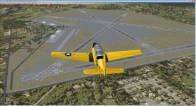
I've been modeling NAAS Saufley Field as it was in the late '50's early 60's, at least as close as I can get it.
Does anyone have any info on what the radio frequencies for the station were back then? I have this from an old sectional, but I can't figure out what the frequencies are for (old format).

Cut off to the bottom left, you can see the ...EY RADIO is
NAVY SAUFLEY RADIO
227 NUN (and the morse code)
Basically says
85 (alt) L H (pattern) 62 (6200 Longest runway)
GCA (Radar Ground Control Approach) DF (Directional Finder)
275 126.18
142.74 293.8
121.5 141.12
132.3
I assume 121.5 is ground and 132.3 is the tower? What are the others? Which is ATIS (I assume they had that back then?)?
275 is DF? 126.18 ATIS?
How did GCA and DF work for approach? Where was the DF signal located? What is it? (I assume not ADF as PNS is clearly marked).
I've got the scenery pretty well going, thanks to Jim Dhaenens' hangars and the RAF buildings library. Still looking for other buildings and pictures of the facility to build off of. I'm also working on Guy Diotte's T-34 static model to adapt it for multiple skins. I've got a bunch of period skins made for it, but I'm still trying to figure out how to get ModelconvertX to get it so I can put them all in one library. Looking for a T-28 Static model, too. Don't know if Tim's model is light enough for that.
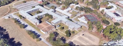
I'm also looking for runway / taxi lighting information, and approach ils / vasi / papi information from back then when it was a training field. As I've said before, my dad was in flight training back in 1957, and I'm trying to recreate the field back then. Any photos of the T-34's from the mid to late 50's would be useful too. I've got his log book and bu no's of the planes he flew, but no idea what the side numbers of the planes were for the planes. Any photos of the field from pre-prison days would be really helpful. Thanks
Tom

From these photos and more


(Aww, how come my images aren't appearing in the message?)
I've been modeling NAAS Saufley Field as it was in the late '50's early 60's, at least as close as I can get it.
Does anyone have any info on what the radio frequencies for the station were back then? I have this from an old sectional, but I can't figure out what the frequencies are for (old format).
Cut off to the bottom left, you can see the ...EY RADIO is
NAVY SAUFLEY RADIO
227 NUN (and the morse code)
Basically says
85 (alt) L H (pattern) 62 (6200 Longest runway)
GCA (Radar Ground Control Approach) DF (Directional Finder)
275 126.18
142.74 293.8
121.5 141.12
132.3
I assume 121.5 is ground and 132.3 is the tower? What are the others? Which is ATIS (I assume they had that back then?)?
275 is DF? 126.18 ATIS?
How did GCA and DF work for approach? Where was the DF signal located? What is it? (I assume not ADF as PNS is clearly marked).
I've got the scenery pretty well going, thanks to Jim Dhaenens' hangars and the RAF buildings library. Still looking for other buildings and pictures of the facility to build off of. I'm also working on Guy Diotte's T-34 static model to adapt it for multiple skins. I've got a bunch of period skins made for it, but I'm still trying to figure out how to get ModelconvertX to get it so I can put them all in one library. Looking for a T-28 Static model, too. Don't know if Tim's model is light enough for that.
I'm also looking for runway / taxi lighting information, and approach ils / vasi / papi information from back then when it was a training field. As I've said before, my dad was in flight training back in 1957, and I'm trying to recreate the field back then. Any photos of the T-34's from the mid to late 50's would be useful too. I've got his log book and bu no's of the planes he flew, but no idea what the side numbers of the planes were for the planes. Any photos of the field from pre-prison days would be really helpful. Thanks
Tom
From these photos and more
(Aww, how come my images aren't appearing in the message?)


")


 Looking forward to this one!