• There seems to be an uptick in Political comments in recent months. Those of us who are long time members of the site know that Political and Religious content has been banned for years. Nothing has changed. Please leave all political and religious comments out of the forums.

    If you recently joined the forums you were not presented with this restriction in the terms of service. This was due to a conversion error when we went from vBulletin to Xenforo. We have updated our terms of service to reflect these corrections.

    Please note any post refering to a politician will be considered political even if it is intended to be humor. Our experience is these topics have a way of dividing the forums and causing deep resentment among members. It is a poison to the community. We appreciate compliance with the rules.

    The Staff of SOH

  • Server side Maintenance is done. We still have an update to the forum software to run but that one will have to wait for a better time.

Global Surface Water

rhumbaflappy

Charter Member
The Global Surface water files are ready for download at my URL.

(Maybe Rami can help get them into the Library. The files are very big.)

GlobalSurfaceWater_West.zip

GlobalSurfaceWater_East.zip


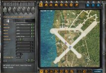
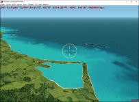
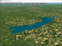
The Global Surface Water collection of land-water masks for CFS2 are a set of LWM BGLs that cover the earth with new land and water.

The collection is derived from Europen Commission's Joint Research Centre Global surface Water project's Transition rasters.
https://global-surface-water.appspot.com/download

The cleaning the ocean areas are derived from OSM ocean data.
http://openstreetmapdata.com/

Issues:

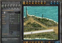
The default beaches will need to be removed or excluded to hide them from view.
Some land areas will need landclass adjustments to insure their display.
These BGLs will completely cover any land or water beneath them in the Scenery Library order.

Some Missions and GSL object placements may be affected.

Recommendations:

The downloads are in 2 parts, _West and _East due to upload restrictions of Sim OutHouse.

I place all the GSWCFS2*.bgls in a single directory named "Global Surface Water", inside a nested "scenery" folder.

I place "Global Surface Water" above the FS2000_prop entry in the Scenery Library...
that would be after FS2000_prop in the Scenery.CFG file

If older land water sets are after FS2000_prop in the Scenery.CFG file, they will have priority, and by simply deactivating the
"Global Surface Water" Scenery Library entry, you'll restore older missions and GSL to their older usage. Some GSL and Missions
will not be affected as placement problems will only be near shorelines.

"rhumbaflappy"
Richard Ludowise
April 3, 2019
 
Thanks very much Dick. I went for a fly around Sydney and the shorelines are extremely accurate. Well done!

Kevin :applause:
 
Many thanks to Jim Keir and his Slartibartfast and his LWMViewer1.3!

The files correspond to the FS9+ file naming convention. So you should be able to track down specific files. Some creative simmers might use LWMViewer1.3 to make a bitmap of the LOD5 area, and use it in Ground2Kv4 to create shorelines and roads. :)

It will be a while, but I might be able to come up with some auto-generated shorelines (beaches). They'd also follow the general naming convention.

Another future project is to come up with a set of landclass files using the same naming convention, but grouped in separate Region folders. That should allow each region to have it's own texture set. The regions are labeled A-Z. Each region could be turned on or off with the Scenery Library if needed. Then Tropical Australia would not need the same textures as the rest of Australia, for example.
 
Rhumba -MR: This is what I get with MR's MN Peleliu in Mission Builder and Free Flight at about 5000 feet. Your coastlines look great but MR's base was built, I believe, for stock coastlines. I'm gonna use it though. MR's recently released MN GI Tarawa-Betio looks as it should.
 

Attachments

  • grab_Pel023a.jpg
    grab_Pel023a.jpg
    147.5 KB · Views: 11
  • grab_Pel028a.jpg
    grab_Pel028a.jpg
    97.2 KB · Views: 10
  • grab_Pel036a.jpg
    grab_Pel036a.jpg
    136.9 KB · Views: 11
Exclude files for the default CFS2 VTP lines

Hi all.

The default CFS2 VTPs need to be removed or renamed as .orig extension or excluded by bgls.

Here a scenery folder you can use to exclude them without renaming or removing:

Exclude_Default_VTP.zip
 
Reply...

Good morning,

Rhumbaflappy, I will work on getting them into the library this weekend. Thanks for all of your work! :wavey:
 
Many thanks to Jim Keir and his Slartibartfast and his LWMViewer1.3!

Another future project is to come up with a set of landclass files using the same naming convention, but grouped in separate Region folders. That should allow each region to have it's own texture set. The regions are labeled A-Z. Each region could be turned on or off with the Scenery Library if needed. Then Tropical Australia would not need the same textures as the rest of Australia, for example.

I have a question on that idea?

Given the range of some aircraft, or on actual missions flown, would switching areas in the Scenery Library possibly be too blunt an instrument? Or would it work to activate the multiple regions the aircraft would fly across?

As an example, the ferry flights made from Melbourne to Darwin and then on to Papua New Guinea, or the missions flown from Tunisia to attack Sardinia, Sicily and Italy would cross several different terrain regions. Both exist in campaigns.

My thanks also for your work on this. As you know the shorelines have always been a source of confusion and problems especially in the Pacific and Balkans areas. So Oh Man! If you are able to do the auto shorelines we'll want to build a virtual CFS2 shrine to you :ernaehrung004:
 
I have a question on that idea?

Given the range of some aircraft, or on actual missions flown, would switching areas in the Scenery Library possibly be too blunt an instrument? Or would it work to activate the multiple regions the aircraft would fly across?

I think each region would have it's own Scenery Library entry, and all regions could be active at once. No switching needed.

You can have a local texture folder with landclass sceneries, if ALL the textures used are in that texture folder, if I recall correctly. So we'd need 26 region entry directories, each having it's own scenery folder for the LOD5 landclass BGLS. And we'd also have in each of those region folders, a local texture folder which would have all the textures needed for that region's BGLs.

For the most part, we all have larger hard drive storage capacity than in the past, so to have a lot of redundant texture storage wouldn't be so bad.

I'm a ways from implementing this. :)
 
Worth the wait then. :encouragement::encouragement:

I wonder. Weird thought but regarding multiple texture folders, has anyone tried aliasing a scenery texture folder? It can work inside the aircraft folders, but would it work if the texture folders in the local scenery folders were aliased to one main texture folder maybe having subfolders divided by landclass type textures?
 
Some Shorelines

Slartibartfast, by Jim Keir, is the main program to generate land-water polys I used. It also makes shorelines for FS2004. It can export BLN text files for the shorelines, but they include the crooked tails that are needed in FS2004 to control autogen.

I've written a program to remove those tails. Not 100% perfect, but not too bad.

Next is creating a CFS2 shoreline from these BLN files. One path to this is to use SBuilder9 to make an SBX file, and then use Sander de Cocq's CFS2AutoCoast to make the BGLs. The problem here is that Sander's program introduces some anomalies:

attachment.php


Alternatives might be to write a program to create a Ground2Kv4 file from the BLN. I remember Christian Fumey did have such a program but never released it publically, so it is possible. Or write a program to do essentially what Sander has already done... but iron out the bugs. I'm going to explore the file structure of Ground2K files, and see if BLN2G2k or SBX2G2k is feasible.

Landclass files will be needed to make the invisible islands appear.

attachment.php


Here's Delavan Lake, Wisconsin, with a "tan_rock" texture:

attachment.php


As always, 2 steps forward and one step back. The process is only semi-automated, and time consuming. I need to brush up on my programming skills. :banghead:
 

Attachments

  • Anomalies.jpg
    Anomalies.jpg
    74.9 KB · Views: 87
  • LandclassProblem.jpg
    LandclassProblem.jpg
    82.7 KB · Views: 84
  • DelavanLake.jpg
    DelavanLake.jpg
    133.3 KB · Views: 84
Great progress.

The artifacts from Sander's program look very similar to the VTP1 number error that you fixed a while back, I'm not sure his latest release of Autocoast (version 3 Release Candidate 1, SEP 2013) needed the VTP lines to be run through your VTPfixer though... I'll go searching back through my archives.
 
Will we still need to provide flattens? I'm pootling around the SWPTO stock locations & see some areas where the watermasks & mesh still look slightly out of synch - flattens would iron out most of these issues I think?

BTW - The India/Burma major river mouth area's look amazing, just crying out for a G2K makeover...:mixed-smiley-010: Might try your LWMviewer bitmap export idea & experiment a little.:playful:
 
Flattens would still be needed in some Area16n flattens areas. As far as anomalies in the vtp lines, I haven't been able to pre-process the BLN files to eliminate them entirely, and I even managed to get uncompilable BLNs.:dizzy: :pop4:

I'm not sure we are using the same version of Sander's program, but the odd lines are generated by CFS2AutoCoast 3.0.5004.18489
 
Back
Top