• There seems to be an uptick in Political comments in recent months. Those of us who are long time members of the site know that Political and Religious content has been banned for years. Nothing has changed. Please leave all political and religious comments out of the forums.

    If you recently joined the forums you were not presented with this restriction in the terms of service. This was due to a conversion error when we went from vBulletin to Xenforo. We have updated our terms of service to reflect these corrections.

    Please note any post refering to a politician will be considered political even if it is intended to be humor. Our experience is these topics have a way of dividing the forums and causing deep resentment among members. It is a poison to the community. We appreciate compliance with the rules.

    The Staff of SOH

  • Server side Maintenance is done. We still have an update to the forum software to run but that one will have to wait for a better time.

Learning Ground2K

RWILLS

Members +
Managed to install Ground2K on an old laptop (Windows 7) and had my first go at learning how to use it.

Thought I'd start a thread in case anyone else is also thinking of trying Ground2K.

Am following the Sander De Cocq tutorial, which seems fairly clear so far, although a few things took a while to work out.


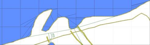
First attempt was to try to put some sort of simple breakwater at Plymouth - attached, seems successful so far!

I particularly wanted to try to do something about the harbour area at Trincomalee/China Bay so may have a go at that next.
 
I am thrilled to find somebody else willing to try their hand at creating scenery using G2K!:p87:

I've attached some of the tutorials/notes I've acquired over the years. Hope these help a little.

My single piece of advice is to save back up copies OFTEN.

G2K has no ability to undo, & large areas can take a long time to compile (some of the Solomon islands took almost an hour to compile). To then find there's an error with a line somewhere, & your bgl cant be generated is somewhat frustrating - doubly frustrating if your last back up was more than a day ago --- I speak from (bitter) experience here !!!

Back up, make some changes, save a copy, try it for compiling (rinse & repeat frequently!!!)
 

Attachments

  • Ground2K_for.pdf
    2 MB · Views: 8
  • Ground2K_US.pdf
    863.1 KB · Views: 18
  • G2K_to_A16N_flatten.txt
    662 bytes · Views: 10
Hi RW,
Great stuff! Glad there's someone else taking on some CFS2 challenges, and thank you for the Plymouth breakwater.

As UT says, save and save often....as when a prog throws a wobbly..you don't have a melt down having not saved (...but I will when I've just done this bit) all evening!! lol.

Cheers

Shessi
 
Thanks for that - I'll have a read through.

Attached is my first effort at improving China Bay - Trincomalee.

My understanding, from what I've read so far, is that I can't create water that joins the sea, as this will cut through an existing land polygon (?), so I'm aiming to leave a narrow strip of land (where there is actually a bridge now - Kinnya Bridge).

The conversion of decimal degrees to degrees, minutes, seconds, within Ground2K, doesn't seem quite as expected, so still some experimenting to do.

Somehow I've also managed to produce a _9.bgl file this time as well as the _3.bgl file, - not sure how/why that happened, or what I'm supposed to do with it?
 

Attachments

  • China Bay.zip
    2.2 KB · Views: 7
I'm not having much success with trying to create an airfield. Have gone through the same process as before but nothing shows in CFS2.
I've not managed to break CFS2 yet though, which is encouraging!
Attached is basic drawing of the correct location for Ngoro airfield in Java where the 17th PS were based in Jan/Feb 1942.
 

Attachments

  • Ngoro Airfield 1942 17th PS.jpg
    Ngoro Airfield 1942 17th PS.jpg
    153.7 KB · Views: 200
Re Ground2K

It is possible to create a LWM water poly that joins the sea, using implication (see ground2k_us pdf I attached earlier for how this works), but it's not ideal.

It's better to first draw a water lwm to cover the entire island, then draw in a new land lwm that includes the river inlet. But then you're creating an entire island, & that's a much bigger project than you might want to undertake...

The _9.bgl means you've drawn at least 1 vtp2 line. The tool to use to find it is Jim Keirs LWM Viewer. You can select the _9.bgl to view it, this should give you an idea of where it is in your G2K project.
 
Re. Ngoro airfield

Unfortunately you'll struggle to create airbases using G2K.

The tool you need is FSSC. This let's you create runways, AFD & A16N flattens.

I think the tutorial by Maskrider is the best starting point regarding blended airfields.
 
Something to point out when using FSSC for CFS2 is that FSSC uses Area( 5 but CFS2 uses Area( A for runways

The below example is straight out of FSSC

Area( 5 S20:02:05.69 E148:12:46.01 12 )
LayerCall( :L000020 24 )
Jump( : )
:L000020
Runway( S20:02:05.68 E148:12:46.01
Alt 0.0
Heading 56.3
Length 5701 ; in feet
Width 298 ; in feet
Markers 00
Id 35
Lights 3
Surface 40
Threshold 0
ThrOffN 0
ThrOffF 0
ExtN 0
ExtF 0
)
Return
EndA

This is the same runway edited for CFS2


Area( A S20:02:05.72 E148:12:46.01 12 )
LayerCall( :L000020 24 )
Jump( : )
:L000020

Runway( S20:02:05.68 E148:12:46.01
Alt 0.0
Heading 56.3
Length 5701 ; in feet
Width 298 ; in feet
Markers 00
Id 35
Lights 0
Surface 0x40
Threshold 0
)
Return
EndA

Default CFS2 runways don't use ThrOffN, ThrOffF, ExtN or ExtF

Cheers
aussie
 
I managed to install FSSC and it seems to be working ok. Also so far seems much easier to used than Ground2K.

Already created a few very basic runways - attached.

Am struggling with Ground2K to get any shorelines working at all. Attempted to create a shore around Corregidor and CFS2 just crashed when I tried to open a mission file to have a look!!
 

Attachments

  • Brereton_Route.zip
    4.5 KB · Views: 3
fixed! - attached - I somehow managed to place Cloncurry Airfield about 600miles away from where it should be by transposing the co-ordinates.

So far I've got Ground2K and FSSC installed and working (not 100% sure the Ground2K is working properly though) on Windows 7.

Is anyone using these (and other) programs on Windows 10?

One of the main reasons for trying to learn how to create basic runways is that I find the assorted runways that can be placed in Mission Builder, are either horrible, or CFS2 often decides it can't find them when I open a mission file, even though they are fine in Mission Builder.
 

Attachments

  • Brereton_Route revised.zip
    4.5 KB · Views: 6
For a runway to show up in Mission Builder you need to add an entry to your airbases.dat file.

You can do this using Notepad, just be sure to create a backup file first ...
 
Something to point out when using FSSC for CFS2 is that FSSC uses Area( 5 but CFS2 uses Area( A for runways

The below example is straight out of FSSC

Area( 5 S20:02:05.69 E148:12:46.01 12 )
LayerCall( :L000020 24 )
Jump( : )
:L000020
Runway( S20:02:05.68 E148:12:46.01
Alt 0.0
Heading 56.3
Length 5701 ; in feet
Width 298 ; in feet
Markers 00
Id 35
Lights 3
Surface 40
Threshold 0
ThrOffN 0
ThrOffF 0
ExtN 0
ExtF 0
 )
Return
EndA

This is the same runway edited for CFS2


Area( A S20:02:05.72 E148:12:46.01 12 )
LayerCall( :L000020 24 )
Jump( : )
:L000020

Runway( S20:02:05.68 E148:12:46.01
Alt 0.0
Heading 56.3
Length 5701 ; in feet
Width 298 ; in feet
Markers 00
Id 35
Lights 0
Surface 0x40
Threshold 0
 )
Return
EndA

Default CFS2 runways don't use ThrOffN, ThrOffF, ExtN or ExtF

Cheers
aussie


Aussie, this is interesting, not least because runways created in FSSC seem to display without any problems. Does this "incorrect" coding have any side effects we should be aware of?
 
Thanks for that - I'll have a read through.

Attached is my first effort at improving China Bay - Trincomalee.

My understanding, from what I've read so far, is that I can't create water that joins the sea, as this will cut through an existing land polygon (?), so I'm aiming to leave a narrow strip of land (where there is actually a bridge now - Kinnya Bridge).

The conversion of decimal degrees to degrees, minutes, seconds, within Ground2K, doesn't seem quite as expected, so still some experimenting to do.

Somehow I've also managed to produce a _9.bgl file this time as well as the _3.bgl file, - not sure how/why that happened, or what I'm supposed to do with it?

Hi RW,

As UT mentions, I find LWM Viewer indispensable for redoing coastal scenery. If you navigate to the area you want to modify using LWM Viewer, you can obtain your NW/SE coordinates, the coastline, rivers and roads.

Here is the bitmap I used for modifying Zeebrugge. After excluding the bits I didn't want, the green lines are the new coast, harbour and canals.
 

Attachments

  • Zeebrugge.jpg
    Zeebrugge.jpg
    215.4 KB · Views: 171
Aussie, this is interesting, not least because runways created in FSSC seem to display without any problems. Does this "incorrect" coding have any side effects we should be aware of?

Hi John,

Well that's where it gets more interesting.

Note the layer call,

LayerCall( :L000020 24 )
Jump( : )
:L000020


I generally remove that too and only included it here for the benefit of people starting out in scenery design. The only time I use layercall is if there's more than one runway in close proximity but if there's only one runway you will notice a difference in the surface, it's slightly clearer textual wise and the aircraft sits on it better and doesn't sink into it as much. I figure too that MS used Area A for a reason so I've always used it in my work.

Cheers
aussie
 
Hi RW,

As UT mentions, I find LWM Viewer indispensable for redoing coastal scenery. If you navigate to the area you want to modify using LWM Viewer, you can obtain your NW/SE coordinates, the coastline, rivers and roads.

Here is the bitmap I used for modifying Zeebrugge. After excluding the bits I didn't want, the green lines are the new coast, harbour and canals.

That looks useful.
I'm still making no progress with shorelines, - and a couple of other bits in Ground2K such as re-mesh don't seem to work (for me). Will have another go it that.

FSSC seems very user-friendly/robust to use, I've created some basic runways/airfields (attached) , and thinking about trying the MR Blended Scenery tutorial. I also had a thought that the polygon tool could be used to place a masked/blended bitmap, but only if the 4 quadrants of the bitmap could be swapped (diagonally) accurately?
 

Attachments

  • Runways.zip
    13.6 KB · Views: 5
Check the pdfs I attached at post #2.

There's a note in the relevant part of the ground2k_us document that suggests nobody has ever got re-mesh to work - I certainly never have got any results with remesh, having to resort to creative use of A16N flattens instead ...

Are you checking the vtp1 box in the "line" tan in G2K?
Vtp2 lines are something else that just doesn't show up in CFS2.


Yes, - I'm working my way through those pdfs. I'm pretty sure I've tried everything for the lines/coast. A file is generated, but CFS2 just either crashes, or shows no obvious sign of any coast/waves texture. I need to try again a few more times

It would be nice to get the remesh to work especially in coastal areas, small islands/rocks/rivers where the A16N flattens can be a bit too smooth for the desired effect.
I may try using 2 flattens at different heights close to each other, and see what happens??
Some sort of "hedge" line equivalent of the coast/shore line could be a useful texture to help blend in scenery (and avoid having to use too many tree objects in mission builder).
 
I'm assuming you had worked out that you needed to use only lines that are in CFS2 for shorelines? They are all the ones at the bottom of the listing, you need to scroll down to select them...
 
I'm assuming you had worked out that you needed to use only lines that are in CFS2 for shorelines? They are all the ones at the bottom of the listing, you need to scroll down to select them...


Yes, I eventually worked that one out this morning. I've managed to create a shoreline at last that at least displays, which is good progress.
 
Back
Top