• There seems to be an uptick in Political comments in recent months. Those of us who are long time members of the site know that Political and Religious content has been banned for years. Nothing has changed. Please leave all political and religious comments out of the forums.

    If you recently joined the forums you were not presented with this restriction in the terms of service. This was due to a conversion error when we went from vBulletin to Xenforo. We have updated our terms of service to reflect these corrections.

    Please note any post refering to a politician will be considered political even if it is intended to be humor. Our experience is these topics have a way of dividing the forums and causing deep resentment among members. It is a poison to the community. We appreciate compliance with the rules.

    The Staff of SOH

  • Server side Maintenance is done. We still have an update to the forum software to run but that one will have to wait for a better time.

Try this route while flight simming....

yank51

Charter Member 2011
Just when you think you've heard it all.... how 'bout this....???
Giant Concrete Arrows That Stretch Across America.

GetInline.aspx


Ever so often, usually in the vast deserts of the American Southwest, a hiker or a backpacker will run across something puzzling: a large concrete arrow, as much as seventy feet in length, sitting in the middle of nowhere.

GetInline.aspx


What are these giant arrows?
Some kind of surveying mark?
Landing beacons for flying saucers?
 
And the rest of it....


GetInline.aspx


Nope. They are actually arrows marking ......
The Transcontinental Air Mail Route!

GetInline.aspx


On August 20, 1920, the United States opened its first coast-to-coast airmail delivery route, just 60 years after the Pony Express closed up shop. There were no good aviation charts in those days, so pilots had to eyeball their way across the country using landmarks. This meant that flying in bad weather was difficult, and night flying was just about impossible.

The Postal Service solved the problem with the world’s first ground-based civilian navigation system: a series of lit beacons that would extend from New York to San Francisco. Every ten miles, pilots would pass a bright yellow concrete arrow. Each arrow would be surmounted by a 51-foot steel tower and lit by a million-candlepower rotating beacon.
(A generator shed at the arrow's tail powered the beacon)!

GetInline.aspx


Now mail could get from the Atlantic to the Pacific not in a matter of weeks, but in just 30 hours or so. Even the dumbest of air mail pilots, it seems, could follow a series of bright yellow arrows straight out of a Tex Avery cartoon. By 1924, just a year after Congress funded it, the line of giant concrete markers stretched from Rock Springs, Wyoming to Cleveland, Ohio. The next summer, it reached all the way to New York, and by 1929 it spanned the continent uninterrupted, the envy of postal systems worldwide.

GetInline.aspx


Radio and radar are, of course, infinitely less cool than a concrete Yellow Brick Road from sea to shining sea, but I think we all know how this story ends. New advances in communication and navigation technology made the big arrows obsolete, and the Commerce Department decommissioned the beacons in the 1940s. The steel towers were torn down and went to the war effort. But the hundreds of arrows remain. Their yellow paint is gone, their concrete cracks a little more with every winter frost, and no one crosses their path much, except for coyotes and tumbleweeds.

AND NOW... YOU KNOW THE REST OF THE STORY!!!
Pretty Cool.... Huh?
 
That's pretty cool, but I presume the arrows aren't part of default FS9. If somebody were to make a scenery object arrow, I'd take a crack at placing them about where they lie. I remember a few times playing hide and seek with aircraft in online flying (goofy days). It was extremely hard to spot an AC on the ground, as I suppose it is in real life so these would be even harder.
 
after browsing through a potload of sites last night,i was able to locate a tower that is still standing not far from me,its excalty 900 yards from moms best friends home according to google earth,so i called them and asked if theyve ever seen it..turns out that shirl and one of her walking partners take the trail to the tower and make a turn back into thier community.
 
It's interesting to note that Montana is the only state that still maintains and operates 19 lighted beacons:

http://www.mdt.mt.gov/aviation/beacons.shtml
<dt>Night-time Lighted Airway Beacons</dt><dd>The night-time lighted airway beacon system is unique to the state of Montana. In the 1920s and 1930s, radio navigation for aircraft was virtually non-existent. Instead, early pilots relied upon a system of federally operated lighted airway beacons. Some of these beacons were quite literally bonfires, lighted and stoked by hardy patrons. Electronic bulbs later replaced the bonfires, lighting airway corridors across mountains and plains for pilots to follow at night and during inclimate weather. As technology improved, airway beacons became a thing of the past. Today, Montana is the only state that still utilizes part of this historic network through our rugged western mountains. Division personnel climb and maintain approximately 19 of these beacons on a regular schedule, also providing ownership and ground leases for their operation.</dd>
 
This is funny, but, when I posted this, the pictures were there!! I remember something about MGT would review pictures, so maybe there is some sort of "you can't use these" rule going on here. Got this as an email, and my first attempt at posting ws denied as I tried to get 6 pictures up there,and there is a 4 picture limit per post....:very_drunk:
 
Does anyone have any idea of the measurements of these arrows? Might try to make one for my first gMax project.
 
Great find!! Some of these are the ones included in the original email I received. still not sure why they were removed though, guessing it's some copyright issue...

No its the way you are coping the email. The forum software does not like the code used to embed the picture in the email.

If you look at the code its actually trying to connect to your email account. Since I am not logged into your email account I can not access the pictures. I had to remove the img tags to get it to show the code you embedded.

Code:
https://snt151.afx.ms/att/GetInline.aspx?messageid=22901eea-ad14-11e3-af19-00237de3e41e&attindex=3&cp=-1&attdepth=3&imgsrc=cid%3apart1.05060804.04000707%40hotmail.com&cid=526221866615376f&hm__login=yank51&hm__domain=hotmail.com&ip=10.148.182.8&d=d3500&mf=0&hm__ts=Mon%2c%2017%20Mar%202014%2023%3a58%3a16%20GMT&st=yank51&hm__ha=01_1be9a242e3d365ebd6ef41ff32f515da9e398eaa515c250e81b5a4c989598116&oneredir=1

To embedded the pictures here you would have to copy them to your PC then post them to the forums as an attachment.
 
Pat,

"The Postal Service solved the problem with the world's first ground-based civilian navigation system: a series of lighted beacons that would extend from New York to San Francisco. Every ten miles, pilots would pass a 70-foot concrete arrow on the ground which was painted a bright yellow. At the center of each arrow there would be a 51-foot steel tower, topped by a million-candlepower rotating beacon. Below the rotating light were two course lights pointing forward and backward along the arrow. The course lights flashed a code to identify the beacon's number. If needed, a generator shed at the tail (or feather end) of each arrow powered the beacon and lights".
From:
http://www.geog.ucsb.edu/events/dep...foot-concrete-arrow-in-the-middle-of-nowhere/

This link has a diagram of the original site configurations.
http://paleofuture.gizmodo.com/the-highway-of-light-that-guided-early-planes-across-1466696698

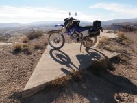
Apologies if someone else covered this ground already, a little woozy from some skin cancer stuff earlier today. There is also something else I found that indicated the arrows were in the 50 foot range...

Bike Arrow.jpgMaybe this helps a little also.

Some great reference material and good conversations about this on the Net. Apparently there may still be one or two near me or just could be coordinates of where they once were, unsure. I may go in search of this weekend with my measuring tape.
 
I won't promise immediate results for two main reasons. First one is I am just starting to learn the vagaries of gMax and the other reason is that I am slowly packing/throwing out stuff in readiness for a house move when the Department of Housing find me another house over on the Central Coast of New South Wales around the Gosford area. So this project will probably take some time.
 
No reason to hurry Pat. I've been working on an airport for the better part of 5 years and I'm still not finished. Real life got in the way and I went on 'hiatus' for about 3 years while my wife went through 2 liver transplants. It was just too much work being primary caregiver and working on building an airport. Thankfully she's much better; the second transplant was a success and her Hepatitis C was eradicated. Six months ago I began work again and spent a few weeks re-learning everything I forgot about gmax. You'll gain a new respect for the devs who knock out planes and scenery in what seems like a few weeks.
 
Hi,

DC3 Airways produced a wonderful add-on scenery for night flights all across the USA, using those beacons with green and white guide lights; so to be able to fly some of them in daylight would be fantastic!
I saw that in some pictures they are designed as junctions to guide the pilots in their turns as well.

Andy.
 
No its the way you are coping the email. The forum software does not like the code used to embed the picture in the email.

If you look at the code its actually trying to connect to your email account. Since I am not logged into your email account I can not access the pictures. I had to remove the img tags to get it to show the code you embedded.

Code:
https://snt151.afx.ms/att/GetInline.aspx?messageid=22901eea-ad14-11e3-af19-00237de3e41e&attindex=3&cp=-1&attdepth=3&imgsrc=cid%3apart1.05060804.04000707%40hotmail.com&cid=526221866615376f&hm__login=yank51&hm__domain=hotmail.com&ip=10.148.182.8&d=d3500&mf=0&hm__ts=Mon%2c%2017%20Mar%202014%2023%3a58%3a16%20GMT&st=yank51&hm__ha=01_1be9a242e3d365ebd6ef41ff32f515da9e398eaa515c250e81b5a4c989598116&oneredir=1

To embedded the pictures here you would have to copy them to your PC then post them to the forums as an attachment.

Dave,
Thanks!! I knew there was something wrong with what I was doing, because when I "previewed" the post, the pictures were there. But, on return, they were gone, and I figured if it was some sort of copyright issue, you (or someone) whould have notified me....:wavey:
 
Back
Top