• There seems to be an uptick in Political comments in recent months. Those of us who are long time members of the site know that Political and Religious content has been banned for years. Nothing has changed. Please leave all political and religious comments out of the forums.

    If you recently joined the forums you were not presented with this restriction in the terms of service. This was due to a conversion error when we went from vBulletin to Xenforo. We have updated our terms of service to reflect these corrections.

    Please note any post refering to a politician will be considered political even if it is intended to be humor. Our experience is these topics have a way of dividing the forums and causing deep resentment among members. It is a poison to the community. We appreciate compliance with the rules.

    The Staff of SOH

  • Server side Maintenance is done. We still have an update to the forum software to run but that one will have to wait for a better time.

Question about SbuilderX

hello :wavey:

Sorry if this is not the place to post.

I am using the SbuilderX 314 (64-bit) and have the following questions:

Zoom = 12 plus a number Tiles = 1232 (44x28 at zoom = 14). How many meters per pixel are? , 2m / pixel ?, 4m / pixel? .......

thanks

regards

Brisafresca
 
All I can tell you is that if you plan to use the image for your ground texture, a zoom level of less than 16 is useless. . . .in fact, if the area I'm using isn't too large, and I can get it to accept a zoom level of 18 I'll use that.
 
All I can tell you is that if you plan to use the image for your ground texture, a zoom level of less than 16 is useless. . . .in fact, if the area I'm using isn't too large, and I can get it to accept a zoom level of 18 I'll use that.

hello

True, it is an evil zoom level for VFR, but do not want to VFR to IFR but I need that level of zoom to save space on the hard disk to cover large areas.

attachment.php
 

Attachments

  • 2015-5-18_0-16-54-353.jpg
    2015-5-18_0-16-54-353.jpg
    119.6 KB · Views: 0
The master here will be Roger-Wilco-66. Mark should have a detailed answer once he comes on board.

Saving space on a hard disc to me means fewer used MB. This said the closer the zoom and more detail the larger the file. As Ed said zoom levels below 16 are almost impossible to achieve. The message comes up that "unable to form image." As to the number of meter / pixel, Mark may have an answer for that.
 
Level 14 generates a file at 2.38m and it gets halved from their as you drop the resolution. Going from 14 down to 13 only saves about 10% in file size, yet is half the resolution. Level 12 is barely recognizable for my area and at 9.5m res., I do not think it would render in FSX.
 
[Edit] Thanks for the "master", Tom, but I think I'm just a tinkerer :)

SBX Zoom levels

level 16 ---------> 1.19m
level 17 ---------> .59m
level 18 ---------> .30m

Note the steps.
If I recall right I took note of these numbers from a post by you, Lance (meshman). That makes you the master, hehe.

If you know the geo dimensions (e.g. length in meters) of your tile you can also easily calculate the mpp number.

Anything below 16 has less of a resolution than the default scenery landclass tiles (1 mpp), this is why 16 is the magic border.

Cheers,
Mark
 
The master here will be Roger-Wilco-66. Mark should have a detailed answer once he comes on board.

Saving space on a hard disc to me means fewer used MB. This said the closer the zoom and more detail the larger the file. As Ed said zoom levels below 16 are almost impossible to achieve. The message comes up that "unable to form image." As to the number of meter / pixel, Mark may have an answer for that.


Sure?, I did it


Level 14 generates a file at 2.38m and it gets halved from their as you drop the resolution. Going from 14 down to 13 only saves about 10% in file size, yet is half the resolution. Level 12 is barely recognizable for my area and at 9.5m res., I do not think it would render in FSX.


Right, thanks is 2.38 meters per pixel. LOD14=2,4m/pixel, I found this table in tileproxy web:

Sin%2Bt%25C3%25ADtulo.png


[Edit] Thanks for the "master", Tom, but I think I'm just a tinkerer :)

SBX Zoom levels

level 16 ---------> 1.19m
level 17 ---------> .59m
level 18 ---------> .30m

Note the steps.
If I recall right I took note of these numbers from a post by you, Lance (meshman). That makes you the master, hehe.

If you know the geo dimensions (e.g. length in meters) of your tile you can also easily calculate the mpp number.

Anything below 16 has less of a resolution than the default scenery landclass tiles (1 mpp), this is why 16 is the magic border.

Cheers,
Mark

I know how the minimum recommended for photorealistic sceneries is 1m / pixel, but take up much space, for so if I want to make large tracts of land no choice but to lower the resolution.

At low level, very poor, I dont like, for VFR flights not good
2015-5-18_14-1-10-539.png


At 15.000ft MSL, It looks decent
IMrnz3MsCyQu8Zh7gloqd4fo34JGvYqpxG-kUVxN-MI=w1550-h822-no


At 30.000ft MSL Its look Good
2015-5-18_0-16-54-353.png
 
Another consideration in PR scenery is resolution at altitude. For VFR flying an acceptable resolution may work well for 5-10k AGL. As you approach your destination scenery you can bump up your resolution as you approach ground level.

The determining factor I use is how many tiles I insert into a given resolution. For example I typically "add map from background" at zoom level of 14 using 56 x 40 @ zoom = 17. This results in a tile download of 2240 tiles. This would be the level of resolution I would use at ground level i.e. an airport or point of interest.

The surrounding terrain that would typically be seen from a higher altitude, I would reduce to zoom 16 or even less if I were covering a large land area to be viewed from altitude.

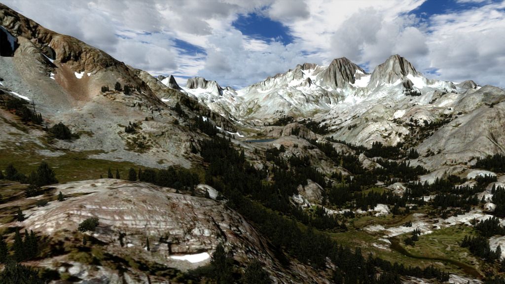
Example of zoom 17 @ 56 tiles. At this resolution individual boulders and foot paths can be see in very acceptable detail.


If you are wanting to conserve space you can store your land mass tiles on a remote storage device and only load them when needed.
 
Wow, those look really nice gman! Is that scenery published/available anywhere?


This is WIP scenery, one of five in the queue for release. Site members here will get updates as I get close.
IMHO high def photo real and hyper accurate autogen annotations produce the most desirable sim environments.
 
This is WIP scenery, one of five in the queue for release. Site members here will get updates as I get close. IMHO high def photo real and hyper accurate autogen annotations produce the most desirable sim environments.
Definitely agree. Looking forward to it! :)
 
Another consideration in PR scenery is resolution at altitude. For VFR flying an acceptable resolution may work well for 5-10k AGL. As you approach your destination scenery you can bump up your resolution as you approach ground level.

The determining factor I use is how many tiles I insert into a given resolution. For example I typically "add map from background" at zoom level of 14 using 56 x 40 @ zoom = 17. This results in a tile download of 2240 tiles. This would be the level of resolution I would use at ground level i.e. an airport or point of interest.

The surrounding terrain that would typically be seen from a higher altitude, I would reduce to zoom 16 or even less if I were covering a large land area to be viewed from altitude.

Example of zoom 17 @ 56 tiles. At this resolution individual boulders and foot paths can be see in very acceptable detail.

If you are wanting to conserve space you can store your land mass tiles on a remote storage device and only load them when needed.


If true, when you approach your destiny is recommended to increase the resolution, I had in mind.

Excellent scenery, how do you do to display the photorealistic scenery with autogen?

Regards

Brisafresca
 
Back
Top