Bill Kestell
Charter Member
FLY THE HUMP ... ABSOLUTELY!
1. Download and install Alex Nicolson's cbixV1.
2. Download and install "roger_wilco_66" CBI scenery mesh and subsequent updates.
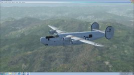
3. Put a C-46, C-47, C-54 in your hangar. (PS You should also buy Virtavia's B-24 Liberator with the C-87 & C-109 add-on)
4. Fire up and go flying!
I've been flying "The Rock Pile" for over 18 months now using THE ALUMINUM TRAIL by Chick Marrs Quinn as my "mission planner" as it is a fantastic collection of the aircraft lost over the Hump from 23 September 1942 to 3 November 1945. I fly to complete the missions they never did. To date I have officially logged 487 hours and several hundred "unofficial" hours in test and check flights over it. Right now I'm up to September 1944; so I'm far from finished.
A little something about Alex's cbixV1. You get it all in one, easy to use package. Hundreds of airfields from West India to East China and hundreds of NDB beacons so you can navigate with your ADF. You also get historically accurate flight routes and even some Approach Charts copied from original USAAF documents.
And then there's Mark's CBI mesh downloads. Folks, you haven't seen the Hump using the stock Microsoft program ... once you add this to your computer the Hump suddenly jumps out at you. Magnificent, beautiful, deadly.
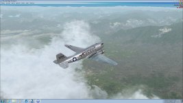
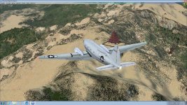
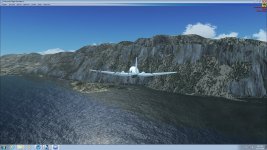
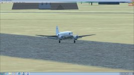
#1 A C-47 "ASSAM AIRLINES" climbs for altitude outbound from Sookerating to Kunming on the High Hump

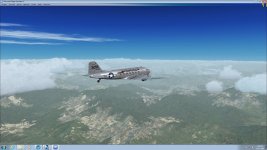
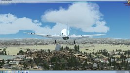
#2 Here she is, at altitude, 18,000', cruising happily along.

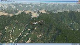
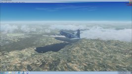
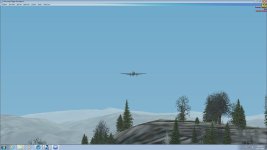
#3 Here's a C-46 "Curtiss Calamity" heading to Kunming at 18,000'

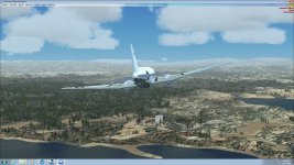
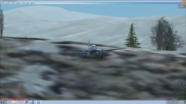
#4 Here's another C-46 "Whale" at 15,000' heading back to Chabua from Kunming, just ready to clear the Mt. Tali Monastery.

1. Download and install Alex Nicolson's cbixV1.
2. Download and install "roger_wilco_66" CBI scenery mesh and subsequent updates.
3. Put a C-46, C-47, C-54 in your hangar. (PS You should also buy Virtavia's B-24 Liberator with the C-87 & C-109 add-on)
4. Fire up and go flying!
I've been flying "The Rock Pile" for over 18 months now using THE ALUMINUM TRAIL by Chick Marrs Quinn as my "mission planner" as it is a fantastic collection of the aircraft lost over the Hump from 23 September 1942 to 3 November 1945. I fly to complete the missions they never did. To date I have officially logged 487 hours and several hundred "unofficial" hours in test and check flights over it. Right now I'm up to September 1944; so I'm far from finished.
A little something about Alex's cbixV1. You get it all in one, easy to use package. Hundreds of airfields from West India to East China and hundreds of NDB beacons so you can navigate with your ADF. You also get historically accurate flight routes and even some Approach Charts copied from original USAAF documents.
And then there's Mark's CBI mesh downloads. Folks, you haven't seen the Hump using the stock Microsoft program ... once you add this to your computer the Hump suddenly jumps out at you. Magnificent, beautiful, deadly.
#1 A C-47 "ASSAM AIRLINES" climbs for altitude outbound from Sookerating to Kunming on the High Hump
#2 Here she is, at altitude, 18,000', cruising happily along.
#3 Here's a C-46 "Curtiss Calamity" heading to Kunming at 18,000'
#4 Here's another C-46 "Whale" at 15,000' heading back to Chabua from Kunming, just ready to clear the Mt. Tali Monastery.


") . I fly back to Duckie tonight
. I fly back to Duckie tonight 
 Them & Eastern.