-
Please see the most recent updates in the "Where did the .com name go?" thread. Posts number 16 and 17.
-
IMPORTANT INFORMATION - ALL MEMBERS PLEASE READ
Please see this thread for updates. Update Thread
SOH ADMINISTRATION
You are using an out of date browser. It may not display this or other websites correctly.
You should upgrade or use an alternative browser.
You should upgrade or use an alternative browser.
Do you have any interesting pictures or projects?
- Thread starter bobhegf
- Start date
miamieagle
Charter Member
Looking Good!
bearcat241
SOH-CM-2023
Beautiful shots MR!!!  ...oh man you make the CFS2 PTO look outta sight!
*********************************************************
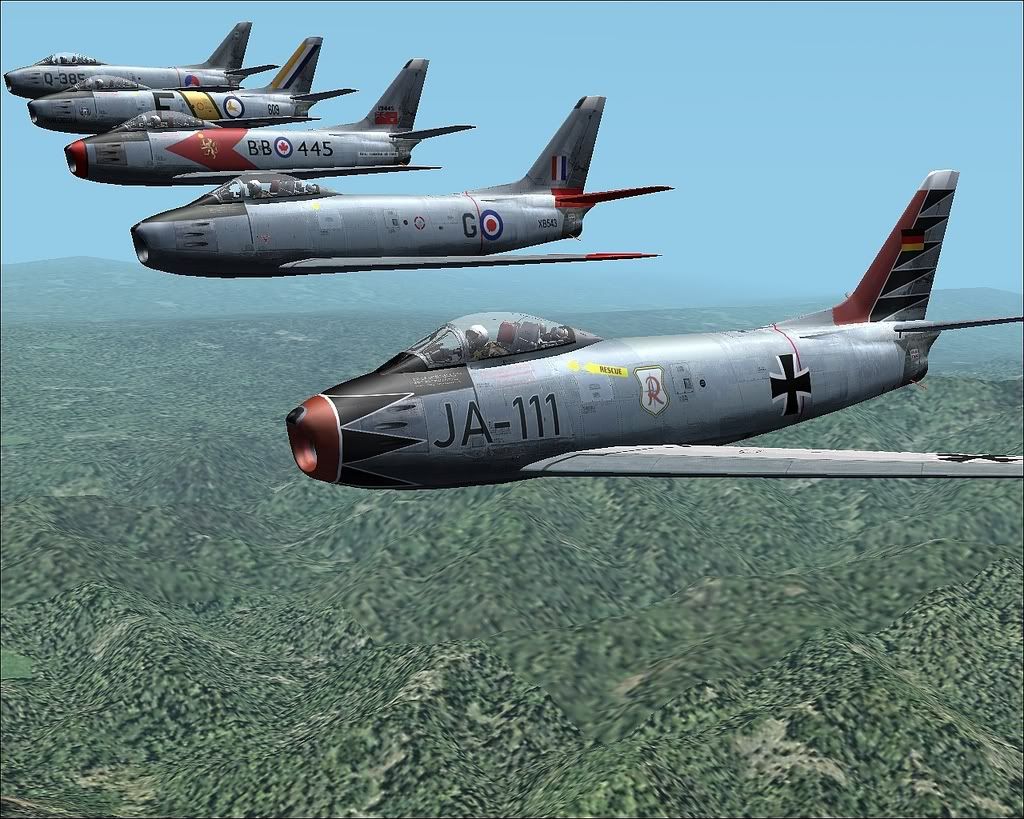
Here's a bit for the United Nations...lookin' forward to seeing more skins of other nationalities represented with the S8 Sabre...
The one in the foreground done by Markus Hellwig, "JA-111", was the aircraft of the Geschwaderkommodore (CO) of JG 71, Oberstleutnant (Lt.Col.) Erich Hartmann...you guys remember him, right?
...oh man you make the CFS2 PTO look outta sight!*********************************************************
Here's a bit for the United Nations...lookin' forward to seeing more skins of other nationalities represented with the S8 Sabre...
The one in the foreground done by Markus Hellwig, "JA-111", was the aircraft of the Geschwaderkommodore (CO) of JG 71, Oberstleutnant (Lt.Col.) Erich Hartmann...you guys remember him, right?
Ravenna
SOH-CM-2023
Beirut 1941
Still very much a work in progress. Even though I've GSLised it I've discovered that the water in the harbour is a bit "hilly" and (I assume as a consequence) some of the lengths of breakwater sit above the "valleys".
How do I flatten the water but leave most of the town with its characteristic slope down to the sea?
xx
Beirut
The second pic is very much like beirut then and even now.The hills surrounding are exactly like that to eventually climb up to 800 mt's.The P40's of the RAF used to land at the airport south of the city and port coming in from Damascus.I was born there right at the waterfront at the tip of the city
"Ras Beirut".
dog1
A couple more. That is not all by a long shot. Panels being reworked, VC panels getting gauges, DP files being tweaked and changed, so many paint templates being made.
Not really doing any real serious work right now...just piddling around aimlessly. Have a lot of projects that are close to being done...but for some reason once I get them nearly done....I kind of put them aside and begin new projects. I think I like the intensity of the initial work involved with new projects than I do the tedious end-run of projects...at least right now. Need the distraction from the pile of stresses in my daily life....and new projects give me that far better than actually wrapping them up and uploading them.
At some point, all these projects will be done and poor Douglas is going to catch bloody heck when I begin uploading all of them.
OBIO
A nice thread!
I am fiddling with Sanders Autocoast tool.
My main focus is an update of the red Square, because I have some scenery attemps there and this is very basic work. Partially the detail will be rather high and there is much hand-edited in this area. If all is done at once in one file, there is no need to patch one file on the other.
I am at the Land-Water-Mask level here.
Beside, I am trying to get used to his autocoast tool and try to learn the next steps: Coastlines. I choosed the still blank areas in Norway for that.
I plan only to use the FS9 information and not dig deeper here.
However, this rather dense scenery with multiple lakes and islands is rather complex. Turning it into a Land-Water-Mask isn`t that tricky, but calculating a coastline takes my PC some hours (and with open outcome!), just as Sander wrote.
I start it in the evening and hope to find the generated file next morning, but sometimes it had hanged up during the process.
With roads, rivers and streets I had no luck at all yet.
The next pics show:
- The corner, where Sanders work ends.
- My first LWM-attemp still with gap in the lakes
- closed gaps, shorelines
Finally Achims Trondheim scenery (no gsl-stuff yet) lying at the shore.
Note, that I haven`t used the white beach texture for an open sea coast here. I think, it does not match the real appearance of a Norwegian coast.
Note, also, that there are straight lines. Only with these, I was able to get a coastline calculated. With smoothened curvy lines, the complexity increases and I am not able yet to get a coastline generated here.
Sopwith Chameleon
Proud Junior Member
 .............there's some new stuff @ the Paintshop ............... http://sopwithc.wetpaint.com/
Jean Bomber
Landscape Gardener
Hi all !
Nice ,there always something to do or upgrade in this game on different places and domains
To applies the process more away in the part I know, I've started a big project ... ,the fourth in the list after the truk lagoon challenge,Gibraltar strait and Oran-Mers el Kebir
(these last are in fact two parts of the same ).
France Manche ,as I've called it,is a long way,Cotentin to Pas de Calais passing by the Seine and Normandy beaches ,but in this kind of scenery work if you make directly the right things the time consuming is more productive,you make every things one time and that's all....the g2k work, at the begining ,need a adaptation time where you draw.....remove.....erase....time consuming to
test....etc....:isadizzy:but at the start the right position ,the coords of the background bmp is the most important
Time consuming also to known the limitation of g2k ,its bugs and how organize the LWM files and their folders,cause at the end each project can have severals LWMfiles:isadizzy:,so now I make folder in g2k for each with their own files .
the first pic is the background bmp for the Le Havre area made with a three psp layers ,a height bmp,a swdb bmp and a old fifty us army map from perry castaneda site ,these map
have good coords.
I scale the three bmps in psp and by decreasing their opacity as I want ,for the road i increase the old map to the top,for
the coast and stream the swdb etc...
2nd pic ,the area covered by the FM project and the work done, land and water mask ,the vtp1 lines,coast, beach ,road ,railways etc...
the result on the ground ,Cotentin pics, even a begin of a work of the other side of the channel...a test on the cliffs of dovers ,last pic...
This project is like a great pullover to make ,this will be done for the next year ,I've some to finish before.....I finish in fact to learn the g2k tool
,I'm at the land and water class values chapter,raw files etc .... how to work with,and also a screenshot inventory for each value was needed ,the renderind is completly different between a pactex and a euro tex set..
this is the work part I'm finishing in the Gib Oran project to have the sceneries completly done ,I could already upload them but they are not completed and i don't want upload fix to upgrade them....
Dombral work also on the gsl aspect of these Med sceneries ,he wait for them
@+
JP
Nice ,there always something to do or upgrade in this game on different places and domains
To applies the process more away in the part I know, I've started a big project ... ,the fourth in the list after the truk lagoon challenge,Gibraltar strait and Oran-Mers el Kebir
(these last are in fact two parts of the same ).
France Manche ,as I've called it,is a long way,Cotentin to Pas de Calais passing by the Seine and Normandy beaches ,but in this kind of scenery work if you make directly the right things the time consuming is more productive,you make every things one time and that's all....the g2k work, at the begining ,need a adaptation time where you draw.....remove.....erase....time consuming to
test....etc....:isadizzy:but at the start the right position ,the coords of the background bmp is the most important
Time consuming also to known the limitation of g2k ,its bugs
and how organize the LWM files and their folders,cause at the end each project can have severals LWMfiles:isadizzy:,so now I make folder in g2k for each with their own files .the first pic is the background bmp for the Le Havre area made with a three psp layers ,a height bmp,a swdb bmp and a old fifty us army map from perry castaneda site ,these map
have good coords.
I scale the three bmps in psp and by decreasing their opacity as I want ,for the road i increase the old map to the top,for
the coast and stream the swdb etc...
2nd pic ,the area covered by the FM project and the work done, land and water mask ,the vtp1 lines,coast, beach ,road ,railways etc...
the result on the ground ,Cotentin pics, even a begin of a work of the other side of the channel...a test on the cliffs of dovers ,last pic...
This project is like a great pullover to make ,this will be done for the next year ,I've some to finish before.....I finish in fact to learn the g2k tool
,I'm at the land and water class values chapter,raw files etc .... how to work with,and also a screenshot inventory for each value was needed ,the renderind is completly different between a pactex and a euro tex set..
this is the work part I'm finishing in the Gib Oran project to have the sceneries completly done ,I could already upload them but they are not completed and i don't want upload fix to upgrade them....
Dombral work also on the gsl aspect of these Med sceneries ,he wait for them
@+
JP
Ravenna
SOH-CM-2023
Does that B-29
have the Mary Whitehouse seal of approval?:costumes:
have the Mary Whitehouse seal of approval?:costumes: