
• Please see the most recent updates in the "Where did the .com name go?" thread. Posts number 16 and 17.

    Post 16 Update

    Post 17 Warning old domain name stealing credentials

  • Special Server Maintenance

    Just when you think you have everything running some what better...

    You get a message from the Hosting company. Short story they need to move us to a new server. I have been working with them to plan a good date for all concerned. Here is what we have come up with as a schedule.

    1. November 4th 17:00 -5UTC shut off the forums and start backup proceedures. During this time there will be no access to the forums or the Resource Section.
    2. November 5th Continue with Backups and download same until complete.
    3. November 6th 7:00 turn over server to hosting company to move system to new server
    4. November 7th - 8th restore backups and upgrade forum software.

    If all goes well we should be back online on November 8th.

    To keep you updated we will post updates on AVSIM forums.

    Thank you for your support.

Flooded river basin?

DaveKDEN

Charter Member
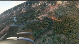
Pardon if this has been answered before... Is there a setting change or fix for the "flooded" river basin effect? You can see the stream path clearly defined right in front of the wing. However, further back the water effect seems to have flooded out the entire basin. This is common for me in all river/stream/creek areas.
Freeware Mig-15 in default Palo Duro Canyon State Park SE of Amarillo, TX. Visited there a few years back, and it's well worth a look if you're looking for something a bit different.
PDSP3.jpg
 
This is indeed a problem with rivers and streams. Apparently their engine detects streams on the photo tiles and applies a linear water path that has a more or less fixed width.

I have tried editing them locally in developer mode with water exclusion polygons and their behavior is strange so I let them be. They even look bad from a distance when sunlight is reflected, especially when they are streams coming down from mountains.

Thanks Dimus - that's what I was afraid of. Too bad, as it detracts from the immersion factor in MSFS.
 
Back
Top