-
Please see the most recent updates in the "Where did the .com name go?" thread. Posts number 16 and 17.
-
IMPORTANT DOWNLOADING INFORMATION - ALL MEMBERS PLEASE READ
Please see this thread for updates. Update Thread
SOH ADMINISTRATION
You are using an out of date browser. It may not display this or other websites correctly.
You should upgrade or use an alternative browser.
You should upgrade or use an alternative browser.
Fort Frank
- Thread starter RWILLS
- Start date

Nice. It will be good to refine the entire area, and around to Subic Bay. The missions/campaign are good with the airfields being in the combat zone. - I've done a very quick Carabao (and Monja) in G2K, but as with Forth Hughes/Caballo it's just flat an at sea level so fairly rubbish, but a lot better than the blob that was there before and really helps as points of reference when flying. Hopefully a lot of the work on Fort Frank will be useful for doing the same with Fort Hughes, Fort Wint and maybe even Corregidor. I've still got to work out how to convert the CAD model into a scenery object for CFS2 but I can at least make some .dxf/.obj files and make them available if someone wants to have a play with them. I've managed to install Gmax and can import .dxf files no m so I can also save models as Gmax files now as well. 

Interesting work gentlemen. The Philippines islands were so very important in the Pacific war and as yet underdeveloped for the game.
I've had a look at a few programs that claim to be able to create mesh, but haven't made any progress with them. It would be nice to find a way to get the mesh function in G2K to work! Currently I'm having a look (occaisionally!) at FSRail, but as with almost all of the CFS2 related software, the learning process is slow and painful, with a lot of going around in circles.
gmax file of the bare island attached if anyone wants to play with it. View attachment Fort_Frank_gmax_file.zip
I've had a look at a few programs that claim to be able to create mesh, but haven't made any progress with them. It would be nice to find a way to get the mesh function in G2K to work! Currently I'm having a look (occaisionally!) at FSRail, but as with almost all of the CFS2 related software, the learning process is slow and painful, with a lot of going around in circles.
I made some mesh with G2K for the Kiel Canal and the Firth of Forth. The mesh was very simple compared to what you've done building Fort Frank. The Gmax model of the island looks great. Will the gun batteries be part of the same model?
I'll keep everything separate in a main file, but join things up into a single clean model if this seems the best way. Even if I somehow manage to later find a way to adjust the mesh, then the model will still be useful as a reference. - I've made a quick start at Subic Bay/Fort Wint, and there is some mesh elevation there to work with, although not perfect it might be possible to nudge the island a bit to the right/east and take advantage of the mesh, maybe with a few flattens around the island to get the water level down. - I'm having a bit of success with using the VTP1 poly, over the top of the LWM poly - which allows control over the texture. For the first time I added the coastline to the VTP1 poly rather than as a separate line and it seems (so far!) to not have the annoying floating/disappearing "seaweed" thing slightly offshore, that I was getting with the separate coastline previously. Found some good pics of Battery Koehler being constructed, and also I think there is a steep cable railway from the landing platform with the engine house for this at the top/centre - north of the barracks. It looks like there might then be a tunnel running from there, on to Battery Greer.
 Also made a bit of progress with Modelconverterx/makemdl etc. - I think (?) that the .x files exported form Rhino(6) possibly don't contain information that is required/expected that may define the inside/outside of any surface mesh? But it does look like I can export from Rhino, into either .3ds (for Gmax), or .obj (for modelconverterx) and then modelconverterx can then export the .x file. I haven't managed to get makemdl to work within Gmax as a plugin yet.
Also made a bit of progress with Modelconverterx/makemdl etc. - I think (?) that the .x files exported form Rhino(6) possibly don't contain information that is required/expected that may define the inside/outside of any surface mesh? But it does look like I can export from Rhino, into either .3ds (for Gmax), or .obj (for modelconverterx) and then modelconverterx can then export the .x file. I haven't managed to get makemdl to work within Gmax as a plugin yet.Are you using Fern Marques' Gamepacks and Allen's CFS2 Exploding Objects Using FS2002? If you drop those folders into the main Gmax folder and start Gmax via the FS2002 Gamepack exe file, your exported asm files will be placed in the CFS2_Exploding_Objs_Using_FS2002 folder, where there is a "Make my object" batch file. You can make either a destructible or indestructible object. You will get an error message if you don't include a damage model but the program will still produce an indestructible model.
scoobyman32
Members +
The depth of knowledge and work you guys put into improving our sim never ceases to amaze me. 
kdriver - I managed to download the gamepacks etc sso plan to have a good go at Gmax again. - I've experimented a bit with some flattens at different elevations and had some useable result for Corregidor. - attached might be of use if you are working on Manilla etc.- it's obviously very much in progress. - Fort Wint/Grande Island is ok, Fort Frank/Carabao is just flat. Caballo is ok and I've managed to start growing a hill by using some flattens, Monja is useful to have, and Corregidor is not bad with some flatten combinations keeping the sea level down while raising the land. - The most annoying bit is the "ghost" textures that appear/disappear in the sea as a result of the Corregidor Coastline.
Well done RW - the islands are really good! It looks like you are using Rhumba's water masks. Unfortunately MaskRider's airfields, as well as Manila city, are based on stock water masks.
In order to make your scenery compatible, I think you need to exclude the original islands. This may also get rid of the ghosting effect.
Do you think you can squeeze Kindley field onto Corregidor?
In order to make your scenery compatible, I think you need to exclude the original islands. This may also get rid of the ghosting effect.
Do you think you can squeeze Kindley field onto Corregidor?
-thanks, yes I need to have a good look at the watermasks etc situation as I installed a lot of stuff like that a long time ago when I knew even less about what I was doing! - The ghost textures clearly display on the edges of the "tiles" and don't seem to appear if the coastline is within a single tile. - I have managed to put Kindly in previously so I will have a fresh look at that. I've also just put a small bit of land and coastline under Fort Drum which looks a lot better. I think with Caballo, even if I can't get the mesh refined any further, it at least gives proper "land" that can be dressed with an infrastructure mesh model later. A couple of pics attached.

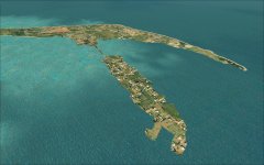
I managed to get Kindley into Corregidor ok, at a reasonable elevation. The shoreline to the north was fairly easy to pull back down to sea level, and there is just a small strip of coastline in the bay immediately south of Kindley that is slightly raised on the resulting sloping/course mesh. Also managed to raise the mesh on the southern bit of the wider landmass half way between Kindley and Malinta (Camp Point) and added an intermediate mesh elevation on the "head" , roughly between where batteries Wheeler and Geary would be - which looks a lot better. Would be nice to improve the south end of Malinta - but I think that will take a while. Haven't had any success though in eliminating the ghost textures in the sea. I've tried on some differing CFS2 installs including a clean original/unaltered install of CFS2 and the textures are still there. I'll persevere with that for a while before posting and new version. Also made some progress with Gmax. - Initially I installed it on the E drive of my old windows7 laptop, but now I've downoaded the add-on Gamepacks, they are set up assuming that Gmax is in the C drive, so I've re-installed Gmax into the C drive and have managed to get as far as exporting a model (Fort Frank) as an FS2002 bgl. The good thing from my point of view is that it looks like I will be able to do all the difficult modelling in Rhino, which gives a lot more control of just about everything than Gmax.
attached (Corregidor, Carabao, Caballo, Fraile Grande Is.)View attachment 89782 is about as good as it's going to be for a while.
I'm hopeful that I will be able to get rid of the ghost textures that appear in the sea. - It's reasonably clear that CFS2 doesn't like the coastlines, or any polygons from Ground2K that cross the edges of the water tiles, and that causes these textures to appear on adjacent edges of the tiles. The solution seems to be to split any coastline into shorter sections that fit within each water tile. I've tried this on a smaller island and the results are promising, but (as usual!!) this also caused the xxx_3.bgl on the island (both the land and the water) to not be properly generated by G2K for some reason, - so I had to generate these before adding the coastline sections, save them so they didn't get overwritten by G2K, and then generate the coastline but discard the xxx_3.bgl that was generated with it. It looks like there might be an optimum distance (short of the edge of the tiles) to stop the coastline, to give the appearance/illusion of continuity but minimise any unwanted effects/textures.