• There seems to be an uptick in Political comments in recent months. Those of us who are long time members of the site know that Political and Religious content has been banned for years. Nothing has changed. Please leave all political and religious comments out of the forums.

    If you recently joined the forums you were not presented with this restriction in the terms of service. This was due to a conversion error when we went from vBulletin to Xenforo. We have updated our terms of service to reflect these corrections.

    Please note any post refering to a politician will be considered political even if it is intended to be humor. Our experience is these topics have a way of dividing the forums and causing deep resentment among members. It is a poison to the community. We appreciate compliance with the rules.

    The Staff of SOH

  • Server side Maintenance is done. We still have an update to the forum software to run but that one will have to wait for a better time.

FreeMesh X Global (May 29)

Wow, sounds good.
I'll compare it to the meshes I have created, if Freemesh is as good I'm out of the mesh creating business!


Cheers,
Mark
 
Wow, sounds good.
I'll compare it to the meshes I have created, if Freemesh is as good I'm out of the mesh creating business!


Cheers,
Mark

Here is 38m so is better than default FSX/P3D mesh, but not very accurate like 5m for example, business will not die ;).
 
Just been reading the avsim thread. Looks really interesting. Essentially this freeware project offers slightly better mesh (LOD 10 instead of LOD9) than FSGlobal, with certain exceptions. These exceptions include places like the Alps where FSGlobal has a higher LOD than it provides for the rest of the planet. However it looks like the FreeMesh team are going to release higher resolution mesh's for these areas in future updates.

All in all it looks like this will become a pretty major contribution to the FSX freeware scene. I know it's early days, but I can imagine this having a pretty severe impact on payware vendors like Pilots. Personally speaking, the only reason I would consider upgrading to another paywhere mesh, from the FSGlobal 2010 I currently use, is if it provides significantly better compatibility with Orbx products.
 
Super nice global mesh in every way in my opinion.

I also think the release has been well thought through, with one big global release instead of trying to do it in bits as has been attempted previously on more than one occasion, it's been done in a way that modern day "FS consumers" (the locust swarm!) can understand.

Like already pointed out, the team is already moving to provide further improved resolution of specific areas of interest.

I hope the project will be hugely succesful, it shows what FS community is really about (and where it came from.).

- JP (seeding ...). :)
 
I can't compare FTX or any other since my tightwad tendencies - and modelling preoccupations - have left me on FSX standard scenery for a long time. Now, the autogen objects and ground textures are still bog standard with Freemesh X Europe, but I've just taken the Milviz Sabre on a 300knot VFR flight over country I know very very well and was able to accurately distinguish landmarks and particular river valleys, ranges of high hills and bodies of water where the family recently wandered. In fact, I didn't get lost!

Greatly looking forward to buzzing the west coast of Scotland! Gotta dash, they've refuelled me now...
 
Once I get out of the "Do tons of crap only two people care about" loop for other projects maybe.
 
My place of choices for pictorial comparison were total duds.

http://i.imgur.com/tKP5lv2.png
http://i.imgur.com/9GE2Ao7.png

N42° 3.05', W73° 58.15'

Wanna guess what's what?
(Hint: Both meshes are at 38m resolution. One is default, one is Freemesh.)


Southern Germany.
Default resolution 76m.
http://i.imgur.com/lfUCb2R.png
FreemeshX. I think I see a mildly higher valley floor and mildly more prominent peaks.
http://i.imgur.com/XAjEUV4.png


Default mesh resolution:
USA - 38m
Europe, Mexico, Canada - 76m (resampled from 90m, which is bad)
Everywhere else - 304 or 608 m (awful or really bloody awful).

If you never stray across the borders of the USA, save the bandwidth. Everybody else, go for it.
 
If you never stray across the borders of the USA it's your own fault! :ernaehrung004:

(At least in the simulator.).

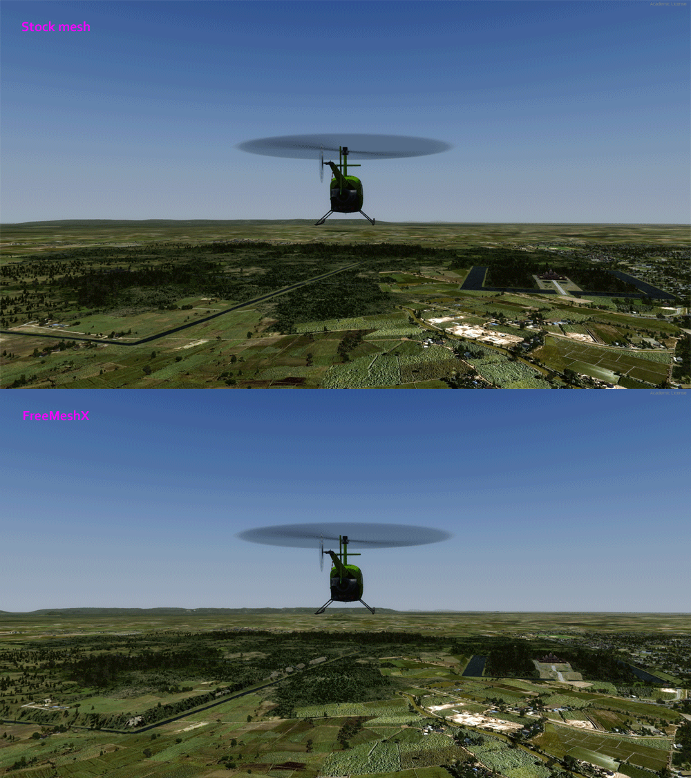
Try a Cambodia comparison, like the Angkor area NE of VDSR Siem Reap.

Also, patch 1.01 is out, correcting two problem tiles in Italy/Balkans. Nice support.

Angkor_meshes_zpsngjcyrjl.gif


(I'll have to re-do my homegrown Angkor Wat now ...). :)
 
Last edited:
Seattle area:


Swiss Alps:


Tenerife, clearly visible is the large crater around the top of the Teide volcano:

 
I did some checks and it seems I'm not out of the mesh business :) At least for those parts of the world I work on.
I also found that using two active custom meshes (e.g. FreemeshX at a lower priority and another one like mine on a higher priority introduce periodic stutters) which I noticed in FSX as well as P3D. So if you fly an area and you notice that the simulator stops every 2-3 seconds you might want to disable the lower prio mesh for the time being.

A very notorious area for mesh errors or anomalies are the Himalayas. The images below are shot around Fort Hertz in northern Burma / Myanmar.

Here's the default mesh (P3D), which is unacceptable to me because it is far from reality:

ft-hertz-defaultmesh.jpg


Here's FreemeshX Asia. I expected that since it's SRTM V3 source. These spikes and holes are present all the way down the hump.

ft-hertz-freewaremesh38m.jpg


Here's my mesh from the ASTER source. The anomalies were worse than SRTM in the source file, but I corrected them (a very laborious task) and the mesh resolution is higher than SRTM V3.


ft-hertz-mymesh30m.jpg
 
Here's my mesh from the ASTER source. The anomalies were worse than SRTM in the source file, but I corrected them (a very laborious task) and the mesh resolution is higher than SRTM V3.

They are suppose to both be 30m source, AFAIK. How it comes out is another thing.
 
I did some checks and it seems I'm not out of the mesh business :) At least for those parts of the world I work on.

Here's FreemeshX Asia. I expected that since it's SRTM V3 source. These spikes and holes are present all the way down the hump.
Here's my mesh from the ASTER source. The anomalies were worse than SRTM in the source file, but I corrected them (a very laborious task) and the mesh resolution is higher than SRTM V3.

Ha! Nobody is going to go out of business! There are certainly artifact prones in FreeMeshX, some of them source, and others sometimes from me (that I'm patching fast to correct)! That's why FreeMeshX is an evolving project, where corrections and new content will added in patches and expansions. The Himalayas for sure have their problems (as do some areas of Oceania as well). These will be corrected in time, free of charge of course. I actually started making my first meshes with ASTER v2 data, but it just had so much noise that I had ditched it once the new 30-m SRTM data was released in late 2014.

They are suppose to both be 30m source, AFAIK. How it comes out is another thing.

Yes, they are both 30-m.
 
I didn't want to step on anyone's toes :) I think the Freemesh initiative is really a great thing and know exactly how much work it is to resample and correct the source data.
As far as I'm concerned I'd really be glad if I could stop resampling large areas myself for these parts of the world where I roam around or develop for.

The reason why my meshes are partly in a higher resolution is because I resample them to a slightly higher density. I also like to "resurface" airfield meshes and the areas around them in the Daylon Leveller because I don't like the huge flat surfaces and imprinting effects that are caused by large flatten polygons. Further, I want to structure the ground like in the image below (berms, sloped runway), and for that you definitely need a custom mesh. So for as long as I make airfields like that I always will concern myself with local meshes.


Cheers,
Mark


cbi-kunming-ab-sloped.png
 
Ha! Nobody is going to go out of business! There are certainly artifact prones in FreeMeshX, some of them source, and others sometimes from me (that I'm patching fast to correct)! That's why FreeMeshX is an evolving project, where corrections and new content will added in patches and expansions. The Himalayas for sure have their problems (as do some areas of Oceania as well). These will be corrected in time, free of charge of course. I actually started making my first meshes with ASTER v2 data, but it just had so much noise that I had ditched it once the new 30-m SRTM data was released in late 2014.

AviatorMoser, as one who has dabbled in the mesh department I am always looking for ways to improve. As you mentioned starting with ASTER v2 data, I am still using that program but will definitely be looking at SRTM data once I find it. My question is what do you mean that the ASTER v2 data had so much noise? I have noticed that from time to time there are spikes and areas that need flattening to remove what looks like an artifact. Is this what you are referring to?
 
Back
Top