• Guest Please check out the Help Wanted thread in Ickie's NewsHawks.
    The future of the Outhouse depends on you!
    Help Wanted

Herber City Airport ICO code

gray eagle

SOH-CM-2024
I am confused. In orbx global airport pack they list a 36U as Herber CIty airport (Utah) aka KHCR. In P3D using 36U will find the airport but not so
using KHCR (Blank) - If you google both ICO they list the same airport. I've not yet come across where the ICO changed. :dizzy:
 
10/27/2017

Changed name from "Heber City Municipal Russ Mcdonald Field" to "Heber City Municipal Airport - Russ Mcdonald Field"
Changed gps_code from "K36U" to "KHCR"
Changed local_code from "36U" to "HCR"
Changed pilot_link from "http://www.airnav.com/airport/K36U" to "https://web.archive.org/web/20171028022618/http://www.airnav.com/airport/KHCR"
That is all well and good Ed but it remains that when I select KHCR, P3D will show a blank, ie nothing, nada, zip, zeltch.
So it the airport is rightfully KHCR, how do I change the title of the scenery from 36R to KHCR in P3D? BTW, I previously saw your link in a quest to solve issue.
 
That is all well and good Ed but it remains that when I select KHCR, P3D will show a blank, ie nothing, nada, zip, zeltch.
So it the airport is rightfully KHCR, how do I change the title of the scenery from 36R to KHCR in P3D? BTW, I previously saw your link in a quest to solve issue.
I know from past experience (my local Airport had a name change as well) that it can be difficult. If you have ADE it can be done in there but it's not a simple task.
 
I know from past experience (my local Airport had a name change as well) that it can be difficult. If you have ADE it can be done in there but it's not a simple task.
Ed, I do have ADE and familiar with some aspects of it. Like a car I can drive it but not race it like NASCAR. If I call this airport up in ADE, I'm pretty sure I won't see any trees so some other area of ADE that maybe you could coach me to go and fix the tree issue. If I dial in a denser veg setting then P3D will populate trees all over with no regard to location to nearby paved surfaces.
I just had cataract surgery completed last week so I have to get use to readers as I type.
 
Last edited:
Checking into the steps, in ADE you must have the "Pro" version (which I paid for but then it became free later on). If you click the "HELP" button at the top far right and do a search for "Changing the ICAO code" it will outline everything.
 
Checking into the steps, in ADE you must have the "Pro" version (which I paid for but then it became free later on). If you click the "HELP" button at the top far right and do a search for "Changing the ICAO code" it will outline everything.
I have the Pro key installed. I will try to follow your suggestions later today , have some errands to run. Thanks for the help.
 
I had to do something like this back in FSX when I created 74X Gun Barrel City Airpark in Texas. I had to create a blank airport in ADEx with the name 6TX5 Harbor Point by calling it up from the stock airports by name in ADEx; deleting everything that ACES had created probably back in FS9; saving it and then activating it in FSX Scenery so that it was nothing but grass so that I could put in the road, buildings custom in Sketchup, airport objects etc. for 74X which was created right next to the old 6TX5 in the real world, that was demolished when the housing development with the private hangers with taxiways to the one runway for those who lived there.
 
10/27/2017

Changed name from "Heber City Municipal Russ Mcdonald Field" to "Heber City Municipal Airport - Russ Mcdonald Field"
Changed gps_code from "K36U" to "KHCR"
Changed local_code from "36U" to "HCR"
Changed pilot_link from "http://www.airnav.com/airport/K36U" to "https://web.archive.org/web/20171028022618/http://www.airnav.com/airport/KHCR"
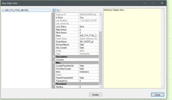
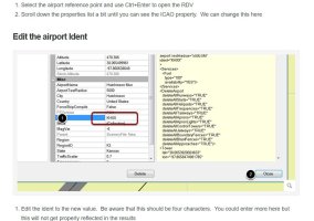
In Adex I opened the airport in Raw Data view as per help info, I was supposed to see the ICAO code in there but not showing. I'm stuck.
 

Attachments

  • Capture.JPG
    Capture.JPG
    60.5 KB · Views: 4
  • Capture1.JPG
    Capture1.JPG
    96.6 KB · Views: 4
Ok, to get to the ICAO code section you must click on the "reference point" Usually located somewhere near the center of the runway (I had to zoom in to locate it), then hit enter and it takes you to where you can change the ICAO code.
 
Ok, to get to the ICAO code section you must click on the "reference point" Usually located somewhere near the center of the runway (I had to zoom in to locate it), then hit enter and it takes you to where you can change the ICAO code.
That worked! Thanks Ed. The scenery loaded as ICAO KHCR in P3D. Now, about the title of the files, (file names) do I change the file names to KHCR?

ADE_FTX_FTXG_36U_CVX.bgl <<< This one is associtated with the 36U airport. I'd like to change the file name for both file to reflect KHCR if possible without any hickups.

36U_ADEP5_ijd.bgl <<< the ICAO was changed and P3D now recognise it as KHCR - Can or how to change the file name?
 
Back
Top