Sextant navigation made simple.
In csse anyone is interested in using the sextant.
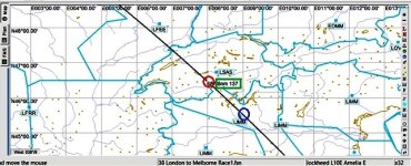
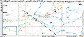
In the illustrations below the aircraft is located at EGUN (blue circle) we have entered an ASSUMED POSITION of 51 DEG 0 MIN LAT (North) and 2 DEG 30MIN LON (East) into the Sextant…..(red circle). You might ask why these coordinates. Notice that the flight path passed through the 51 degree line at about half way between 3 and 4 degrees.
Notice here that this is FSNavigator with everything turned off so as to show ONLY the MAP as recommended in the rules.. Also note that zoomed to x32 (orange circle) that each line of latitude and longitude is exactly 1 degree.
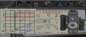
When flying a course of 135 degrees or southeast, think logically about the distance being traveling east and south. For each mile we travel east we’re traveling a mile south as well. Now look at the graph illustration. (That is not to say we travel 1nm of latitude for each 1nm of longitude. These are merely measurement lines and those distances depends entirely on where we are on earth).
Notice where the red and green plotted lines are, in relation to the center of the graph, in the sextant illustration. Reading a star located directly north (Polaris) or south our distance north of our
destination (ASSUMED POSITION) is 75nm. Reading a star directly east or west of us the distance is also75nm.
Keep in mind that
one latitude degree is ALWAYS 60nm apart (1
minute of
latitude = 1 nautical
mile) and each
one degree of Longitudinal is 60nm (ONLY at the equator) and come together at the poles. So how far would you think are the longitudinal lines that are 1 degree part at 45 degrees north or south latitude?
If you said 30nm you were incorrect. They’re actually about 42nm and, unless you want to take a course in solid geometry, we’ll leave it at that.
1 degree latitude = 60nm ALWAYS
http://www.nhc.noaa.gov/gccalc.shtml
Rounded off to the nearest mile.
At N/S 0 degrees latitude = 1 degree longitude= 60nm
At N/S 30 degrees latitude = 1 degree longitude= 52nm
At N/S 45 degrees latitude = 1 degree longitude= 42nm
At N/S 60 degrees latitude = 1 degree longitude= 30nm
At N/S 80 degrees latitude = 1 degree longitude= 10nm
As I stated before, the flight path in this illustration is NOT 135 degrees it is about 141 degrees southeast. If the ASSUMED POSITION was 135 degrees from out aircraft the green line (longitude reading) would have been greater. It just so happened at51 degrees north, a heading of 141 degrees came out to be the distance as the latitude reading
So you can see. Those lines don’t represent Latitude and Longitude they represent distance as you can see on the bottom and left had side of the graph. As we travel along our route we trying to fly to the center. So each time we take a reading we should cross along the imaginary line to the center.
As you can see, there is no need to hover over any map airport or navaid to set in an ASSUMED POSITION in the sextant.
Check out W49 DEG and E5 DEG. A no brainer for a future star shot.
--------------------
Just a couple more things which should be quite obvious. We can only read stars at night (when it's clear).
So celestial navigation is much more difficult using only the sun during the day, which is only good for finding longitude.
There IS one exception during the day. The
high noon shot when the sun is
EXACTLY 180 degrees or 90 degrees north or south depending again of where the the world you are.
As example.
from
http://aa.usno.navy.mil/data/docs/celnavtable.php
Celestial Navigation Data for 2014 Oct 27 at 7:52:30 UT
For Assumed Position: Latitude N 25 40.0
Longitude E 57 50.0
Almanac Data | Altitude Corrections
Object GHA Dec Hc
Zn | Refr SD PA Sum
o ' o ' o ' o | ' ' ' '
SUN 302 09.0 S12 47.3 +51 32.7
180.0
So, as you're flying along you may ask your navigator......Where in the world are we?

I hope this confusing post helps someone.

Fred


