ryanbatc
Charter Member
Ok dokie - no need to discuss NDB's vs GPS (lol) but I have question regarding this NDB approach into Oconto, WI
http://naco.faa.gov/d-tpp/1003/06337NG29.PDF
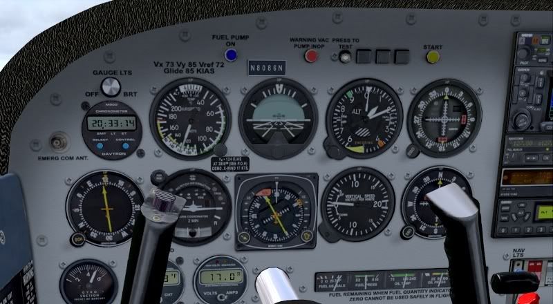
What I have for equipment is an HSI and an ADF indicator with a moveable card under it.
I started by trying to line up the card with my heading (from the hsi) but just got screwed up that way. So I left it where it was and imagined the needle overlayed onto my HSI. From the chart we see the final approach course (or bearing whatever its called) is 301. From my picture here I presume I'm slightly right of course? I'm heading 300-ish and if I were to imagine the adf needle on my HSI it would point at about a 295. How do I know what my deviation is off the final and how do I correct it? Do I turn toward the needle or away??? That's what confuses me the most. Also, when I'm flying outbound prior to reaching the PT, again, do I correct towards the needle or away?
Thanks for any help...
http://naco.faa.gov/d-tpp/1003/06337NG29.PDF
What I have for equipment is an HSI and an ADF indicator with a moveable card under it.
I started by trying to line up the card with my heading (from the hsi) but just got screwed up that way. So I left it where it was and imagined the needle overlayed onto my HSI. From the chart we see the final approach course (or bearing whatever its called) is 301. From my picture here I presume I'm slightly right of course? I'm heading 300-ish and if I were to imagine the adf needle on my HSI it would point at about a 295. How do I know what my deviation is off the final and how do I correct it? Do I turn toward the needle or away??? That's what confuses me the most. Also, when I'm flying outbound prior to reaching the PT, again, do I correct towards the needle or away?
Thanks for any help...
