Pitching Deck

If you don't desire a new entry in the drop down menu, you can simply paste the boat's title in the title textbox.

Acceleration comes with a USCG cutter -- its title is "Veh_USCG_Cutter_Sm", as seen in the Microsoft Flight Simulator X\SimObjects\Boats\Veh_USCG_Cutter_Sm\sim.cfg file. Simply make the program look as follows and click "Create Boat".

g9rSmgK.png
 
Ok cool, now how do I change the location , say to Alaska or wash state ? , it seems that the locations are preset ? , and thank you for your patience on this .

Bill
 
Good vids guys for the small deck landings, up the pucker factor by turning out the lights (I'd say maybe sea state 1-2 in the MH-60R vid, training of course). I don't have my pitch/roll or wind limits handy, but the USN has a limit for each class of boat that is helo capable. Years ago I remember X-Plane 8ish came with selectable pitch/roll for ships, something at the time FS didn't have, so thanks for bringing this to the community orionll!
 
If you don't desire a new entry in the drop down menu, you can simply paste the boat's title in the title textbox.

Acceleration comes with a USCG cutter -- its title is "Veh_USCG_Cutter_Sm", as seen in the Microsoft Flight Simulator X\SimObjects\Boats\Veh_USCG_Cutter_Sm\sim.cfg file. Simply make the program look as follows and click "Create Boat".

g9rSmgK.png

How do I determine the coords (Long/Lat) data to fill in the boxes? Is the Long/Lat in the Shift Z what I can use?
 
Bill: You can edit the latitude and longitude (in addition to the heading and speed) similarly to the boat's title. Just enter the latitude (expressed in decimal degrees) in the textbox next to Latitude, and the longitude (also expressed in decimal degrees) in the textbox next to Longitude. Heading is expressed in degrees (true, not magnetic), and speed is in knots. However, when you edit the textboxes, the settings will not be retained when you restart the program.


Victory103: You're welcome!


gray eagle: As explained to Bill, you must express the latitude and longitude using decimal degrees. I recommend using Bing Maps -- simply navigate to the area you're interested in, right click, and it'll give you the latitude and longitude (in decimal degrees) of the point you right clicked on.
 
Ok , I got it now, downloaded Bing Maps and picked the location That I wanted, made an xml file and called it BoatLocations and pointed to it in the pitchingdeck xml file ie,<LocationFile>C:\Program Files\PitchingDeck\BoatLocations.xml</LocationFile>.
Then just entered the location via Bing maps Lat and Long and wala , we are in business. Thanks abunch . What a blast man.:jump:

Bill

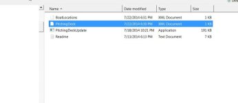
P.S. here is a pic of wht it looks like in my Pitching Deck folder If anyone is wondering
 

Attachments

  • 1.jpg
    1.jpg
    19.9 KB · Views: 0
Ok , I got it now, downloaded Bing Maps and picked the location That I wanted, made an xml file and called it BoatLocations and pointed to it in the pitchingdeck xml file ie,<locationfile>C:\Program Files\PitchingDeck\BoatLocations.xml</locationfile>.
Then just entered the location via Bing maps Lat and Long and wala , we are in business. Thanks abunch . What a blast man.:jump:

Bill

P.S. here is a pic of wht it looks like in my Pitching Deck folder If anyone is wondering

I'm not sure I understand the part about "pointing it to pitchingdeck xml".

I have been trying to make one for the enterprise and so far this is what I made. Don't laugh, I know it's a mess, but I am trying to absorb it all in.


View attachment 10396<locations> <location name="San Diego 2">
<title>VEH_CVN65_Enterprise_80s</title>

When I tried to open it with xml notepad, regular notepad was offered to open it. So I know I've left some stuff out of this.</location></locations>

Can't copy/paste real xml files here. SO I had to make a snapshot of what I had so far.
 
Here's how I did mine. I think of it as the PicthingDeck.xml is "pointing to" the locations.xml file that you create:
 
That's How I did it PRB, I just named the whole folder in the PitchingDeck xml file. Where it says

<LocationFile>https://dl.dropboxusercontent.com/u/19121193/FSX/Web/BoatLocations.xml</LocationFile> . I just inserted

<LocationFile>C:\Program Files\PitchingDeck\BoatLocations.xml</LocationFile>. for my Location so when I click on PitchingDeck icon My edits show up. Hope this helps GreyEagle.

Bill
 
Paul and Bill understand correctly. However, I'd also like to point out that you can have as many LocationFile elements as you like. If you want to keep the default locations, all you need to do is add an additional LocationFile element rather than replacing the existing one.

Edit: Bill, missed your previous post -- you're welcome, and glad you like it!
 
Pitching decks revisited

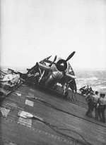
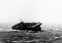
You know it's hard for someone that has not been to sea and experinced every type of it's conditions to get a feel for what happens. However, taking pictures during a steep roll is hard to take. Your busy trying to stand up and not go over the side of the ship or land in the cat walk. But these pictures show what I'm getting at.
carrier.jpgcarrier one.jpgcarrier three.jpgcarrier two.jpg
 
The amount of pitch and roll isn't for me, the inexperienced non-seaman to decide, it's for you, the user. You can set the pitch and bank to whatever you deem necessary -- whether that be one degree or ninety.
 
Here you go Bob, 30 degree rolls off Wake Island, 1942. Of course, all flight operations have been cancelled, and I'm going back to Wake to get a sandwich and some coffee from the CPO mess!

 
You know it's hard for someone that has not been to sea and experinced every type of it's conditions to get a feel for what happens. However, taking pictures during a steep roll is hard to take. Your busy trying to stand up and not go over the side of the ship or land in the cat walk. But these pictures show what I'm getting at.
View attachment 10458View attachment 10459View attachment 10460View attachment 10461

That's great, but exactly how much aviation is going on in those pictures?
 
A Sandwitch

Port Royal in between Nimitz and Ike. Would of been nice to see the skivy wavers (SignalMen) using their flags from the signal bridge or the signal lights flashing. That would
of been pretty neat.


View attachment 10586
 
Back
Top