-
Please see the most recent updates in the "Where did the .com name go?" thread. Posts number 16 and 17.
-
IMPORTANT DOWNLOADING INFORMATION - ALL MEMBERS PLEASE READ
Please see this thread for updates. Update Thread
SOH ADMINISTRATION
You are using an out of date browser. It may not display this or other websites correctly.
You should upgrade or use an alternative browser.
You should upgrade or use an alternative browser.
Ruhr Smog - Pictures and Descriptions Wanted
- Thread starter gecko
- Start date
MajorMagee
SOH-CM-2022
Yes
gecko
Charter Member
Thanks Andy, I'll have to try this out. I think my memory of how the haze works may be faulty. It's been a while since I was working with this aspect of it.Here's the text for the thicker lower version used for the night shots.
<Weather Name="England Low Smog-France Clear">
<BackgroundWeather precipType="NoRain" skyboxCloudType="NoClouds" MaxAltitude="-90" MinAltitude="-100" fogColor="4288789972" Windspeed="0" windDir="0" >
<CloudLayer cloudfile="cloudCumulusSmall.xml" CloudType="ScatteredClouds" CloudRadius="40000" CloudCount="40" Lightning="noLightning" MinAltitude="900" MaxAltitude="900" fogColor="4287542759" />
<CloudLayer cloudfile="CloudCumulus2.xml" CloudType="ScatteredClouds" CloudRadius="45000" CloudCount="12" Lightning="noLightning" MinAltitude="900" MaxAltitude="900" fogColor="4287542759" />
</BackgroundWeather>
<WeatherObject skyboxCloudType="BrokenClouds" MaxAltitude="20000" MinAltitude="0" fogColor="4290432475" Windspeed="8" windDir="270" >
<Bounds>
<Point Lat="N52 54" Lon="E3 41"/>
<Point Lat="N49 22" Lon="E0 2"/>
<Point Lat="N51 9" Lon="W4 48"/>
<Point Lat="N54 16" Lon="W11 14"/>
<CloudLayer cloudfile="dr_sandstorm_cloud.xml" CloudType="ThickClouds" CloudRadius="20000" CloudCount="50" MinAltitude="10" MaxAltitude="5000" fogColor="4288987369" Density="1"/>
</Bounds>
</WeatherObject>
</Weather>
Pat Pattle
SOH-CM-2026
Great work going on here!! ")
MajorMagee
SOH-CM-2022
I checked and multiple boundary areas work as well.
<Weather Name="London Rhur Low Smog - France Clear">
<BackgroundWeather precipType="NoRain" skyboxCloudType="NoClouds" MaxAltitude="-90" MinAltitude="-100" fogColor="4288789972" Windspeed="0" windDir="0" >
<CloudLayer cloudfile="cloudCumulusSmall.xml" CloudType="ScatteredClouds" CloudRadius="40000" CloudCount="40" Lightning="noLightning" MinAltitude="900" MaxAltitude="900" fogColor="4287542759" />
<CloudLayer cloudfile="CloudCumulus2.xml" CloudType="ScatteredClouds" CloudRadius="45000" CloudCount="12" Lightning="noLightning" MinAltitude="900" MaxAltitude="900" fogColor="4287542759" />
</BackgroundWeather>
<WeatherObject skyboxCloudType="BrokenClouds" MaxAltitude="20000" MinAltitude="0" fogColor="4290432475" Windspeed="8" windDir="270" >
<Bounds>
<Point Lat="N51 68" Lon="E1 69"/>
<Point Lat="N51 01" Lon="E1 44"/>
<Point Lat="N51 35" Lon="W1 11"/>
<Point Lat="N52 02" Lon="W0 61"/>
<CloudLayer cloudfile="dr_sandstorm_cloud.xml" CloudType="ThickClouds" CloudRadius="45000" CloudCount="50" MinAltitude="10" MaxAltitude="3050" fogColor="4288987369" Density="1"/>
</Bounds>
</WeatherObject>
<WeatherObject skyboxCloudType="BrokenClouds" MaxAltitude="20000" MinAltitude="0" fogColor="4290432475" Windspeed="8" windDir="270" >
<Bounds>
<Point Lat="N52 02" Lon="E8 11"/>
<Point Lat="N50 63" Lon="E7 53"/>
<Point Lat="N50 34" Lon="E4 16"/>
<Point Lat="N52 63" Lon="E3 85"/>
<CloudLayer cloudfile="dr_sandstorm_cloud.xml" CloudType="ThickClouds" CloudRadius="45000" CloudCount="50" MinAltitude="10" MaxAltitude="3050" fogColor="4288987369" Density="1"/>
</Bounds>
</WeatherObject>
</Weather>
MajorMagee
SOH-CM-2022
I included the industrial parts of Holland and then provided for some drift to the east from the Rhur.
Properly done each industrial city area would have it's own little patch of smog.
Properly done each industrial city area would have it's own little patch of smog.
mongoose
SOH-CM-2026
Ah! So I imagine then one could try 3 or 4 entries in theory? Now you've done the hard work, I might play around!I included the industrial parts of Holland and then provided for some drift to the east from the Rhur.
Properly done each industrial city area would have it's own little patch of smog.
mongoose
SOH-CM-2026
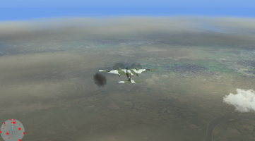
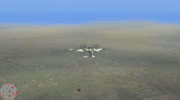
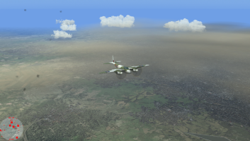
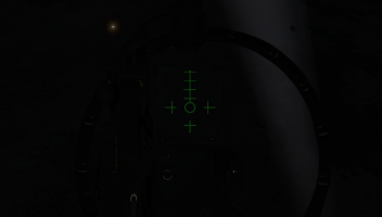
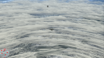
Well my first attempt of cut-paste-change for a <Weather Name="England Low Mist-France Clear-Rhur Smog"> IMHO. not bad as seen by day; at night I couldn't see anything anyway! Maybe with a full moon I might have seen some thing. See screenshots. Still maybe a bit more 'cloudy' than 'hazy' or 'foggy'. Interesting to see what Dan makes of it.
<Weather Name="England Low Mist-France Clear-Rhur Smog">
<BackgroundWeather precipType="NoRain" skyboxCloudType="NoClouds" MaxAltitude="-90" MinAltitude="-100" fogColor="4285571302" Windspeed="0" windDir="0" >
<CloudLayer cloudfile="cloudCumulusSmall.xml" CloudType="ScatteredClouds" CloudRadius="40000" CloudCount="40" Lightning="noLightning" MinAltitude="900" MaxAltitude="900" fogColor="4287542759" />
<CloudLayer cloudfile="CloudCumulus2.xml" CloudType="ScatteredClouds" CloudRadius="45000" CloudCount="12" Lightning="noLightning" MinAltitude="900" MaxAltitude="900" fogColor="4287542759" />
<CloudLayer cloudfile="dr_alto_cumulus_cloud.xml" CloudType="ScatteredClouds" CloudRadius="35000" CloudCount="225" Lightning="noLightning" MinAltitude="7000" MaxAltitude="7000" fogColor="4288987369"/>
</BackgroundWeather>
<WeatherObject precipType="LightRain" skyboxCloudType="ThinClouds" MaxAltitude="450" MinAltitude="250" Windspeed="0" windDir="0" >
<Bounds>
<Point Lat="N52 54" Lon="E3 41"/>
<Point Lat="N49 22" Lon="E0 2"/>
<Point Lat="N51 9" Lon="W4 48"/>
<Point Lat="N54 16" Lon="W11 14"/>
<CloudLayer cloudfile="eto_altocumulus.xml" CloudType="ThinClouds" CloudRadius="46000" CloudCount="1" Lightning="NoLightning" MinAltitude="16000" MaxAltitude="16000" fogColor="4288987369"/>
<CloudLayer cloudfile="cloudCumulusSmall.xml" CloudType="ThinClouds" CloudRadius="40000" CloudCount="100" Lightning="noLightning" MinAltitude="5" MaxAltitude="5" fogColor="4287542759" />
<CloudLayer cloudfile="eto_ground_fog2.xml" CloudType="ThinClouds" CloudRadius="35000" CloudCount="60" Lightning="noLightning" MinAltitude="5" MaxAltitude="5" fogColor="4288987369"/>
<CloudLayer cloudfile="dr_alto_cumulus_cloud.xml" CloudType="ScatteredClouds" CloudRadius="35000" CloudCount="225" Lightning="noLightning" MinAltitude="5" MaxAltitude="5" fogColor="4288987369"/>
</Bounds>
</WeatherObject>
<WeatherObject skyboxCloudType="BrokenClouds" MaxAltitude="20000" MinAltitude="0" fogColor="4290432475" Windspeed="8" windDir="270" >
<Bounds>
<Point Lat="N51 47" Lon="E7 49"/>
<Point Lat="N51 39" Lon="E8 01"/>
<Point Lat="N50 52" Lon="E7 01"/>
<Point Lat="N51 30" Lon="E6 42"/>
<CloudLayer cloudfile="dr_sandstorm_cloud.xml" CloudType="ThickClouds" CloudRadius="45000" CloudCount="50" MinAltitude="10" MaxAltitude="3050" fogColor="4288987369" Density="1"/>
</Bounds>
</WeatherObject>
</Weather>
Day
Attachments

Last edited:


mongoose
SOH-CM-2026
Well that sure looks fine for night, Interesting to see what would happen with any searchlights on. I suppose with B17s in daytime + German set smoke fires for concealment, would make it difficult for accurate targeting, which reminds me, I have to investigate how to do wind driven concealing smoke pots or fires used by the Germans!
mongoose
SOH-CM-2026
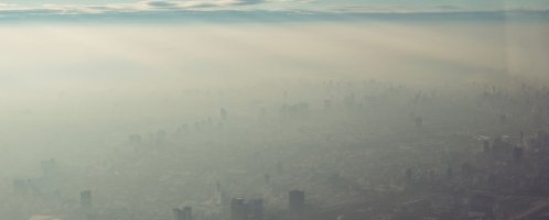
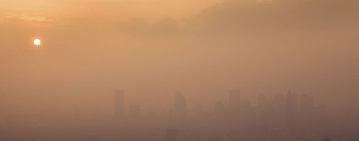
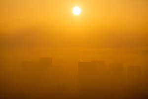
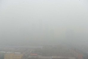
Actually it's very hard to find pics from vertically above, but these may sort of give an idea of what it might have been like, taken from various sources old and new. ".....Another problem was that the Ruhr Valley was so heavily industrialised that there was constant smog in the skies above it, which impeded the bomb aimers but also made it difficult for the navigators to even find the target area."Are there any good photos showing what this looked like from a distance?
For a modern idea
(for some reason you have to backspace on the links if the pics disappear)
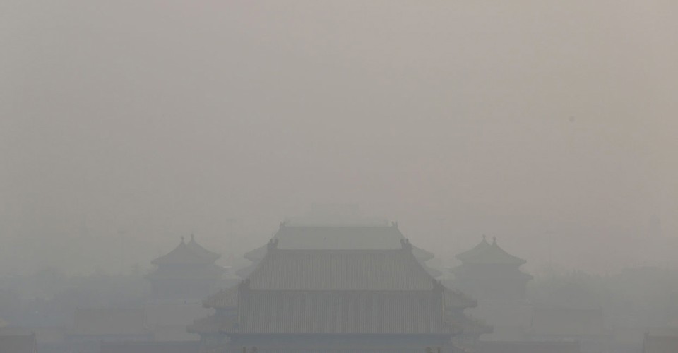
China's Toxic Sky
 www.theatlantic.com
Attachments
Last edited:
mongoose
SOH-CM-2026
Actually that does not happen in many cases, especially conurbations and industrial cities. not criteria met by Leavenwprth; as a metro KC resident I know.Smog like fog will lift and will become a dirty brown cloud. Saw this just the other day as it was hanging like a thin brown stratus cloud just north of Ft. Leavenworth.