• There seems to be an uptick in Political comments in recent months. Those of us who are long time members of the site know that Political and Religious content has been banned for years. Nothing has changed. Please leave all political and religious comments out of the forums.

    If you recently joined the forums you were not presented with this restriction in the terms of service. This was due to a conversion error when we went from vBulletin to Xenforo. We have updated our terms of service to reflect these corrections.

    Please note any post refering to a politician will be considered political even if it is intended to be humor. Our experience is these topics have a way of dividing the forums and causing deep resentment among members. It is a poison to the community. We appreciate compliance with the rules.

    The Staff of SOH

  • Server side Maintenance is done. We still have an update to the forum software to run but that one will have to wait for a better time.

Sim Skunk Works new developed tecnology "RED PANDA"

Being a developer myself, but primarily of warfare stuff (air,land,sea) I have often wished for the ability to realistically deal with mountains and valleys (shadows of radar). I am wondering if there might be some way of taking the fsx terrain data and use the data as you have to "blank" out the areas behind radar obstructions. My impression to date was that you could not detect altitude of objects other than directly below the aircraft - which obviously can't create a viable map of the area. :dizzy:

My NEUWUC programs, are however, freeware, so I completely understand if you don't want to or can't share how you did this. Feel free to pm me if you wish.

In any case, Bravo Zulu in being able to solve this vexing problem! :applause:
 
Hi Findus...
the elevation model, shadowing and others is part of our new technology, not related to FSX or P3D
About you second question I think It should be possible, even if I have not the radar prediction chards (which cover the last 15 Nm near an airport if I understand well what you mean), but for now, we have not planned to upgrade the F104 with RedPanda Technology, but never say never ;)
Regards
Emanuele

Thx for your fast answer!
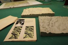
For the F-104 as far as I know, the radar prediction charts were artificialy created using special photographs of scale terrain models. They were used to help the interpretation of the radar image in conjunction with a normal map and the INS to master the low level navigation.
Are your elevation data used by the terrain following radar of your Tornado?


radar prediction 1.jpg
 
@Wizard....the range of elevation shadowing is selectable with the radar range (and change also the range of moving map)...and is part of our technology...nothing comes from FSX or P3D...the elevation shadowing is not only below the aircrafts...in the two videos I think that the radar range is 40Nm ;)

@Findus: for sure...the elevation data will be used by the terrain following radar of our Tornado which will be implemented ;)

@DhazelGrove: in reality inside our work-Group at SSW we had called this technology Shangri-la as the city of the novel of James Hilton, "Lost Horizon", which was the new eden and a totally new world, as the technology is, and that city is located in Tibet. When we decided to launch the technolgy we wanted a name more simple also for who have not read the book.....and because in Tibet (where Shangri-la is located) the sacred animal is the red panda, and this animal looks like the skunk we decided for that name.

Regards
Emanuele
 
Thanks for the info. Sounds like the same solution I've muddled about with, but you seem to have implemented with more fidelity. :encouragement:
 
Hi guys...
Here a new video of the RED PANDA Technology applied to Tornado HUD
Early test using Harrier as test platform, it shows a short landing approach, note the velocity vector symbol and the attitude indicator that follow the sideslip as should be on the real thing.
Enjoy

 
Interesting video, Pluto, but it seems to me that the HUD is not collimated correctly, in that the horizon line is below the outside world horizon. Or am I missing something? But for the rest it makes me hope that the HUD will not only be included in the Tornado but also in the Harrier.<o:p></o:p>
 
Interesting video, Pluto, but it seems to me that the HUD is not collimated correctly, in that the horizon line is below the outside world horizon. Or am I missing something? But for the rest it makes me hope that the HUD will not only be included in the Tornado but also in the Harrier.<o:p></o>

Hi StickShaker,
You notice right but that behaviour of the Horizon line is due to the fact that the HUD Pojection you see is calibrated for the Tornado Projection which is different from the Harrier (I mean HUD Glass dimension, distance of the point of view etc...) ;)
You can be sure that the new Harrier HUD with the new tecnlology will be conformal ;)
Regards
Emanuele
 
Just a couple of things more about the video and the features showed:

- projection lens refraction (the halo It is not a texture or other it is part of the new tecnology)
- HUD font anti-aliasing
- HUD font blurries due to combiner glasses (the combiner glass is a particular feature of the Tornado HUD due to the double HUD glasses...if you will read the manual you will find what is the combiner glasses and what is its peculiarity)
Regards
Emanuele
 
Thanks for the clarification, Pluto. This is very exciting! I have all your aircraft and am looking forward to the Tornado.<o:p></o:p>
 
Back
Top