• There seems to be an uptick in Political comments in recent months. Those of us who are long time members of the site know that Political and Religious content has been banned for years. Nothing has changed. Please leave all political and religious comments out of the forums.

    If you recently joined the forums you were not presented with this restriction in the terms of service. This was due to a conversion error when we went from vBulletin to Xenforo. We have updated our terms of service to reflect these corrections.

    Please note any post refering to a politician will be considered political even if it is intended to be humor. Our experience is these topics have a way of dividing the forums and causing deep resentment among members. It is a poison to the community. We appreciate compliance with the rules.

    The Staff of SOH

  • Server side Maintenance is done. We still have an update to the forum software to run but that one will have to wait for a better time.

The Channel Map

Phantom88

Charter Member


***New Map Revealed** The Channel Map***
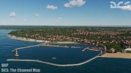
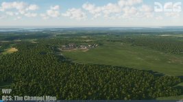
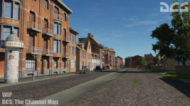
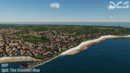
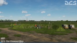
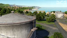
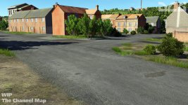
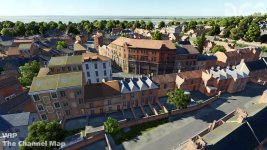
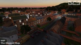
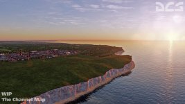
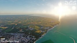
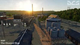
attachment.php
attachment.php
attachment.php

attachment.php

attachment.php


****[FONT=&quot]****Newsletter Info****[/FONT][FONT=&quot]In addition to the Mariana Islands map, we are pleased to announce the first dedicated World War II map for DCS World that is created by Eagle Dynamics: The Channel map! This map will represent southeast England, the English Channel, and portions of the low countries and north eastern France. The map is built to support missions and campaigns between the late 1930s and 1945 with a new level of detail and realism not seen before in a DCS World map. Airfields of the map include:[/FONT]

  • Manston
  • Detling
  • Hawkinge
  • Lympne
  • Dunkirk Mardyck
  • Saint-Omer Longuenesse
  • Merville Calonne
  • Abbeville Drucat
[FONT=&quot] [/FONT]
[FONT=&quot]***It will also include detailed renditions of the cities, towns, road and rail network, forests, rivers, canals, communication lines, radar stations, of this important region during the Second World War.****[/FONT]
[FONT=&quot]***DCS: The Channel Map will be available for pre-order with a 30% discount in early February 2020.***
[/FONT]

More News to follow.......
 

Attachments

  • DCS-Channel_01a.jpg
    DCS-Channel_01a.jpg
    68.4 KB · Views: 1
  • DCS-Channel_02a.jpg
    DCS-Channel_02a.jpg
    103 KB · Views: 2
  • DCS-Channel_03a.jpg
    DCS-Channel_03a.jpg
    117.6 KB · Views: 1
  • DCS-Channel_04a.jpg
    DCS-Channel_04a.jpg
    99.7 KB · Views: 1
  • DCS-Channel_05a.jpg
    DCS-Channel_05a.jpg
    69.6 KB · Views: 1
Last edited:

***new screens in today's news***
attachment.php

attachment.php

attachment.php

attachment.php

attachment.php
 

Attachments

  • The-Channel-Map-02.jpg
    The-Channel-Map-02.jpg
    114.3 KB · Views: 1
  • The-Channel-Map-03.jpg
    The-Channel-Map-03.jpg
    124.7 KB · Views: 1
  • The-Channel-Map-04.jpg
    The-Channel-Map-04.jpg
    82.4 KB · Views: 1
  • The-Channel-Map-05.jpg
    The-Channel-Map-05.jpg
    140.8 KB · Views: 1
  • The-Channel-Map-06.jpg
    The-Channel-Map-06.jpg
    83.9 KB · Views: 1
attachment.php

attachment.php

attachment.php
 

Attachments

  • The-Channel-Map-07.jpg
    The-Channel-Map-07.jpg
    76.1 KB · Views: 1
  • The-Channel-Map-08.jpg
    The-Channel-Map-08.jpg
    77.1 KB · Views: 1
  • The-Channel-Map-09.jpg
    The-Channel-Map-09.jpg
    91 KB · Views: 1
I know this question has probably been asked and answered (forgive me asking again if it has) but looking at the proximity of the Normandy map and the Channel Map, are they going to be connected to where we can cross between the two over the Channel?
 
Hello Storm,I found this answer on DCS forums from one of the moderators......
https://forums.eagle.ru/showthread.php?t=260486

"Hi

It is not possible to merge terrains, they are from different parties.

However I see what you are saying, if a campaign creator chose different locations Normandy or The Channel for individual missions within a campaign that of-course would be possible.
It would mean that the end user would need to own both terrains to purchase the campaign."
 
Thanks for the answer. The way I read that, the user/owner of both maps can do this with the campaign option, essentially it would involved two missions, one starting on one map, the second starting in the air over the second map (not a continuous flight from one map to the other). Perhaps at some point they will come up with a way to interconnect them to where your flight/mission can run continuous between the maps.
 
The aircraft in the first picture are yellow nose P-51 Ds from 361 Fighter Group and definitely not P-47 Thunderbolts........

But nevertheless nice pictures :encouragement:

Cheers,
Huub
 
The aircraft in the first picture are yellow nose P-51 Ds from 361 Fighter Group and definitely not P-47 Thunderbolts........

But nevertheless nice pictures :encouragement:

Cheers,
Huub
lol....yes....I think they're showing The Channel Map in that one:playful: I posted the Jug pics in P-47 thread...sorry for the confusion.
 
This map was released yesterday along with the P-47. I did not get the Jug, but did get the map to try my Spitfire and Muntang. It is very nice but I think it needs some good optimization. I experienced stutters quite often during a dogfight instant mission that made the situation unplayable. I will investigate more with settings as I have them quite high, but it is not a problem in other maps.

It does look great though and hopefully ED will work on optimizing performance. Two snaps I took after the furball with the Antons was over:

E1qR7l2.jpg


AoircIk.jpg
 
Back
Top