• Please see the most recent updates in the "Where did the .com name go?" thread. Posts number 16 and 17.

    Post 16 Update

    Post 17 Warning old domain name stealing credentials

  • Special Server Maintenance

    Just when you think you have everything running some what better...

    You get a message from the Hosting company. Short story they need to move us to a new server. I have been working with them to plan a good date for all concerned. Here is what we have come up with as a schedule.

    1. November 4th 17:00 -5UTC shut off the forums and start backup proceedures. During this time there will be no access to the forums or the Resource Section.
    2. November 5th Continue with Backups and download same until complete.
    3. November 6th 7:00 turn over server to hosting company to move system to new server
    4. November 7th - 8th restore backups and upgrade forum software.

    If all goes well we should be back online on November 8th.

    To keep you updated we will post updates on AVSIM forums.

    Thank you for your support.

Victoria+

Kurdt_Cocaine

Чайка
Hello,

Today I installed Victoria+ and as soon as the install was over I was presented to some issues: VictoriaPlus.exe crashes on start-up and the scenery looks like this;

I can't think of a solution I haven't tried before.. Any help is welcomed!
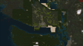
bandicam 2024-07-16 10-33-00-416.png
 
I don't have any of these add-on sceneries but do they happen to use satellite imagery download 'live' from the internet as the source for the landclass textures? If so, it could be that the source website is down or that the license to use the imagery has expired and so the resources have been blocked. A number of online weather tracking sites that used free Google satellite files suddenly lost their map imagery when Google pulled free access and wanted money for use.

Little Nav Map lost it's free Google maps for the same reason and users had to switch to a different free map provider or have blank maps.
I've asked in the official forums and they mentioned ORBX being a requirement for the correct generation of the landclass and mesh so there we go, thanks to all of you for the help!
 
Back
Top