• Please see the most recent updates in the "Where did the .com name go?" thread. Posts number 16 and 17.

    Post 16 Update

    Post 17 Warning old domain name stealing credentials

  • Special Server Maintenance

    Just when you think you have everything running some what better...

    You get a message from the Hosting company. Short story they need to move us to a new server. I have been working with them to plan a good date for all concerned. Here is what we have come up with as a schedule.

    1. November 4th 17:00 -5UTC shut off the forums and start backup proceedures. During this time there will be no access to the forums or the Resource Section.
    2. November 5th Continue with Backups and download same until complete.
    3. November 6th 7:00 turn over server to hosting company to move system to new server
    4. November 7th - 8th restore backups and upgrade forum software.

    If all goes well we should be back online on November 8th.

    To keep you updated we will post updates on AVSIM forums.

    Thank you for your support.

"World Terrain" - New imagery source, new pricing

jschall

Charter Member
Further to my post from 18 months ago: http://www.sim-outhouse.com/sohforums/showthread.php/105611-Anybody-tried-World-Terrain

Version 4 (http://hush-software.com/) abandons Bing as its imagery source, and goes with

"Mapping API provided by ESRI, ArcGIS Runtime SDK for .NET, Earthstar Geographics".

With all those agreements in place, the dev, "Macker" has decided on a yearly subscription model - $60 for 1/3 of the globe, $95 for 2/3, and $120 for all.

I continue to be amazed at how well World Terrain works.
 
I would like to use things like this but I can't get past the lack of autogen (in the amounts and density of what I fly with now, Total Orbx). Also I am not a high flyer, most of my flying these days is at altitudes less than 5000'. . .mostly at 2000'. I also depend almost totally on realistic airports (hence my work to enhance as many small airports as I can). I like the idea of being able to spot familiar landmarks, etc. while I'm flying, but from what I saw on their website awhile ago the ground textures are not color corrected, the autogen is sparce and doesn't present itself very well because of the poor coloring in the ground textures.

I know from experience that hand placing autogen is time consuming and boring as hell. . .I tried it with one package I got for one of the Hawaiian Islands that had no vegetation to speak of. I got maybe an eighth of one side of the Island done and gave up, lol. So yea, it's difficult work, but if I'm going to pay a yearly fee for the use, I want color corrected textures and plenty more autogen vegetation.
 
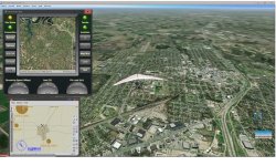
Thanks for the comments, Ed. I don't know what you mean by "color corrected". Here is an example at 5000' over Sherman, TX, with autogen at max.
attachment.php
 

Attachments

  • sherman WT.jpg
    sherman WT.jpg
    120 KB · Views: 0
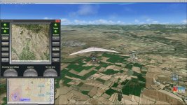
This is what I was looking at on their site. To me the wide variation between the pale ground texture and the autogen vegetation makes these sort of packages undesirable (for me at least). I know they're popular because they are the actual terrains, cities, towns and not a representation, but for me they aren't as vibrant and heavily populated with buildings as vegetation as I'm used to in "low and slow". It's a personal preference and I haven't yet seen anything that would change my mind enough to pay for these packages.

washed_out.jpg
 
Back
Top