• There seems to be an uptick in Political comments in recent months. Those of us who are long time members of the site know that Political and Religious content has been banned for years. Nothing has changed. Please leave all political and religious comments out of the forums.

    If you recently joined the forums you were not presented with this restriction in the terms of service. This was due to a conversion error when we went from vBulletin to Xenforo. We have updated our terms of service to reflect these corrections.

    Please note any post refering to a politician will be considered political even if it is intended to be humor. Our experience is these topics have a way of dividing the forums and causing deep resentment among members. It is a poison to the community. We appreciate compliance with the rules.

    The Staff of SOH

  • Server side Maintenance is done. We still have an update to the forum software to run but that one will have to wait for a better time.

Maskrider?

Hi Gius,

Yes I am. The screenshots in this thread are of airfields where I relied almost exclusively on G2K to do all of the ground texturing and roads and such. If I recall correctly the only screenshot where I used the method in my tutorial is the Morotai. Morotai has a very complex hardstand, taxiway-runway layout- best done using the method described in my tutorial. But everything else in the Morotai scenery is done with G2k. I still use FSSC for all of the basic airfield stuff- runways, start points, flat areas, NDBs, fuel areas, etc..

MR

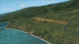
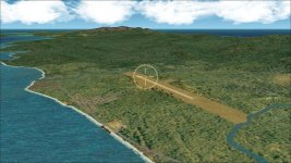
PS: Here are three screenshots of the G2K layout window for all of the ground texturing polys for Babo (the background project map is turned off to make it easier to see). The the zoomed-out shot shows all of the shorelines and airfield ground polys- minus the roads. The roads I do as a separate bgl. The land itself is also a different project and bgl- looks just like the shorlines but its land instead. The zoomed in shot shows just the ground polys directly involved with the airfield. The third shot shows what the road layout looks like superimposed over the rest. If I were to start this project today I would very likely do it as a 2 stage project. First the wider surrounding land and shorelines and then a smaller close-up portion of the area just around the airfield. And of course there is also a landclass and a waterclass bgl associated with the scenery- made using EZLandclass usually.

MR

babo-g2k-layout00.jpg

babo-g2k-layout01.jpg

babo-g2k-layout02.jpg

Hi Chris,
thanks for the reply: very interesting and exciting techniques indeed: personally, mainly working on ETO, i dont need often to work with G2k for ground
particulars, but this way can be very uuseful in building airfields, except the case you must use the method described in your tutorial...congrats again!
Perhaps we can have better detail with Sander's Autocoast package..
As far as OS issues, i'm using G2k in a VMWare Xp virtual machine on a rig running Win7 32 bit since i've encountered the same problems described
by UncleTgt...
Cheers
Gius
 
Gius and UncleTgt,

I have been out of the loop for a while and am not really up to speed on the conflicts and glitches that have arisen between CFS2 and the newer, post-XP, versions of windows. However, I am approaching the point where I will be wanting to build a new computer for the scenery and simming. Windows 7 is as far as I am willing to take it, I think. So, I guess soon I will be looking to pick your guys brains to sort things out if necessary.

Chris
 
Babo

Hi Chris,

Was googling maps and found the modern day Babo.

I'm guessing the circular holes in and around the area are bomb craters from seventy one years ago. Pretty amazing.

Babo.jpg


Captain Kurt did missions for this area. IIRC, 9th Air force. This was a nasty place for US bombers and strafers in 1944.

oh, BTW, I found the .dp's made by Pen32win. They're include in his af_bb_pak.zip. This one has the files for leroy10's objects including the Water tank to Oil storage tank .dp. :victorious:

Dave
 
Last edited:
Alright, Dave! Thanks for the pic of Babo. Good work on those dps! I had a look around my archives but wasn't able to spot them.

Another airfield not too far from Babo- about 35 mile WSW was Sagan. If you look close bomb craters are still visible there, too, along with quite a bit of detail of the taxiway, hardstands and dispersal areas. There even a few revetments still visible as well as what appear to have been gun emplacements or some such thing. It was a bit difficult to find in Google Earth because there is no modern day airfield at the location. But it is still possible to glean a pretty accurate layout from the Googfle Earth picture. I also had a photo from Pacific Wrecks to work from.

FYI Am making good progress and having fun reworking the DEI pack. Sometime in the next fews days I will get something ready for beta testing.

Here are a few pics I have. One is a wartime image of Babo from the Australian War Museum. The other 2 are of Sagan: one from Pacific Wrecks, the other from Google Earth.

BTW here are the coords of Sagan from Google Earth: 2°39'52.82"S 132°57'56.22"E

babo-awm5ed.jpg

sagan-ed-pac-wrecks.jpg

sagan-googlearth.jpg
 
One more of MR Sagan- canted over with N at a 45 degree slant. I actually just starting upgrading this airfield earlier tonight.

MR
sagan-mr.jpg
 
Gius and UncleTgt,

I have been out of the loop for a while and am not really up to speed on the conflicts and glitches that have arisen between CFS2 and the newer, post-XP, versions of windows. However, I am approaching the point where I will be wanting to build a new computer for the scenery and simming. Windows 7 is as far as I am willing to take it, I think. So, I guess soon I will be looking to pick your guys brains to sort things out if necessary.

Chris

Chris,
i'm always ready to help...
Congrats for your works again!
 
Couple of nice screen shots

After finishing up a rework of Nabire Airfield I decided to take a little hop from Nabire NW up to Ransiki Airfield- about 160 miles, with ActiveSky running. For my plane I chose one of my favorites, Akemi San's ki-45kai "Toryu". It was a screenshot worthy flight.
nabire-to-ransiki-map2.jpg

Taking off from Nabire
nabire-ransiki-00.jpg

nabire-ransiki-01.jpg

nabire-ransiki-02.jpg
 
Thank you, Akemi for the enjoyment you are still giving!

Four more:
nabire-ransiki-03.jpg

nabire-ransiki-04.jpg

Passing Moemi heading for Ransiki
nabire-ransiki-05.jpg

On approach to Ransiki
nabire-ransiki-06.jpg

On Final
 
On this project, which I went traipsing off on thanks to dvslats inquiring about Boela Airfield, I am current concentrating on the newer DEI airfields clustered on and around the Vogelkop, or Bird's Head, Peninsula of Western New Guinea or what was Dutch New Guinea. Many slightly older fields, because of the way they were made in the first place, prior to Rhumba's Mesh and Mask, nevertheless fit in fine with his mesh when it was released.

Not all of the newer fields have required reworking, mainly just the ones that were not quite as G2K-intensive as others. For instance, Ceram-Amahai, Hate-Tobako, Lolobata, Jeffeman Island, Middleburg Islanfd, Mar-Sansapor, Pulau Gag and Wadke Island were all pretty much OK as they were.

The first thing that came to mind when I first decided to do this project was to change the roads from textured VTP1 polys without shores to VTP1 lines textured with Jean Bomber's nice road textures. The reason I originally made the roads using polys W/O shores was that at the time there was no decent road texture available that held up well visually. JP came up with some textures that changed that.

Another thing niggling me was the way I had sort of jury rigged river miouths in man of these sceneries. Many of these Islands I had reworked using AutoCoast with the result that they had an unbroken shoreline, which meant that the rivers always flowed into the ocean through a line of sand and waves. So “opening up” river-mouths are another thing I have been tweaking.

Also, when using LWM water polys for rivers, as I usually do, the rivers naturally take on whatever water class value they find sitting under them. Near shore this is almost always going to result in bright sky-blue rivers- when they should be duller and muddier looking. So, I wanted to tweak the river water-class colors.

Another little oddity that arose when Rhumba’s Mesh and Masks were adopted is that new land locations uncovered what had up until then been “hidden” expanses of default “1” water-class along the coasts of many Pacific Islands. This value basically yields a surface that reacts like ground to bullets and more importantly to floatplanes- they get stuck in it. You will be floating along nicely, come to a blended zone border between “1” and “7” water-class, and suddenly flip over onto your nose! So, I also wanted to fix outcroppings of “1” water-class.

Finally, as far as I recall at the moment, I wanted to thin out the GSLs at many of these airfields. Not, surprisingly, simple tweaking has many times turned into major reworks. Sangihe Island, which I am just finishing up, is such a place. I never liked it. So in addition to tweaking it river water classes and opening up its river mouths, I basically trashed the original field and replaced it with one that will be considerably less elaborate but much nicer looking, IMHO, when finished.


So here is the deal. The first batch of of reworked airfields will be released some time soon. I won’t put any hard firm date on it. But I can see the light at the end of the tunnel. I will want some beta tester volunteers to make sure I haven’t overlooked anything.

The list of fields in this first pack: Ceram-Amahai, Ceram-Boela, Ambon-Laha, Babo, Biak, Fak-Fak, Hate-Tobako, Lolobata, Jeffman Island, Mar-Middleburg, Mar-Sansapor, Moenmi, Monakwari, Morotai, Noemfoor Island, Nabire, Pulau Gag, Ransiki, Sagan, Sangihe, Ternate, Utarom-Kaimana, Wakde.


Pretty much all of the airfields in the mr_dutch_east_indies_090912.zip . But they will definitely look different and the file-names will be different. Thus the need for some beta testing to work out any glitches.


Only Noemfoor, Sangihe and Utarom-Kaimana remain unfinished.

The second pack will be a rework of all the DEI fields that were only built for stock CFS2 mesh and masks. I will redo these for the new mesh and masks.They will include: Dili, Kendari, Koepang, Laboera, Langoer, Manado, Namlea, Selaru, Singosari and Waingaipoe.


Cheers,
MR

Find two screenies below showing the old Sangihe Island and vs the in progress new Sangihe.

Old Sangihe:
sangihe-old.jpg


New Sangihe:
sangihe-new.jpg


Another of the new, from the NE
sangihe00.jpg
 
WOW!

:jawdrop:... I can't believe how beautiful the screenshots you posted are, Chris! :wavey:

I love Active Sky, although I will never be able to enjoy it. I despise the idea of having my CFS2-dedicated pc connected to the Net. All of the security involved drains a lot of the precious resources CFS2 needs, besides how can you provide security if XP is not being supported anymore? I was told Active Sky works only when the pc is online, while my CFS2-dedicated pc is 100% 'unplugged', with all of the connectivity and security services turned or deleted off.

May I ask you two quick questions?


  1. What kind of hardware are you using to withstand such beautifully detailed sceneries with XP-Pro? Sadly only XP allows the full-screen option, even if a virtual XP-machine could be used. CFS2 can only be run inside of a DOS window from Win7 onwards.
  2. The mesh detail of the mountains looks like it's Rhumbaflappy's corrected elevation mesh. The shoreline is perfect, yet with Rhumba's mesh installed the Pacific shores are so screwed up I had to revert back to the stock mesh. What mesh files are you using?

Thank you for getting involved again with CFS2! :applause:

Cheers!
KH
:ernaehrung004:
 
... I can't believe how beautiful the screenshots you posted are, Chris!

I love Active Sky, although I will never be able to enjoy it. I despise the idea of having my CFS2-dedicated pc connected to the Net. All of the security involved drains a lot of the precious resources CFS2 needs, besides how can you provide security if XP is not being supported anymore? I was told Active Sky works only when the pc is online, while my CFS2-dedicated pc is 100% 'unplugged', with all of the connectivity and security services turned or deleted off.

May I ask you two quick questions?


  1. What kind of hardware are you using to withstand such beautifully detailed sceneries with XP-Pro? Sadly only XP allows the full-screen option, even if a virtual XP-machine could be used. CFS2 can only be run inside of a DOS window from Win7 onwards.
  2. The mesh detail of the mountains looks like it's Rhumbaflappy's corrected elevation mesh. The shoreline is perfect, yet with Rhumba's mesh installed the Pacific shores are so screwed up I had to revert back to the stock mesh. What mesh files are you using?

Thank you for getting involved again with CFS2!

Cheers!
KH


Hi KH,

I appreciate the kind words about the screenshots! Thanks!

Indeed I do run CFS2 on XPPro even though MS no longer supports it. I keep a couple of reliable, up-to-date security programs running full time whenever I am online with CFS2- indeed they run full time whether I am online or not.

So far, no issues. I try not to take any unnecessary risks.

WRT hardware, mine is actually a very modestly endowed machine:
systeminfo.jpg

As far as the mesh and shorelines are concerned, yes the mesh and most of the masking is Rhumbas corrected mesh. Any shorelines you see in my scenery are strictly my own. I always try to include nicely fitting shorelines with the scenery- but only for a reasonable distance either side of the scenery- unless it is a reasonably sized, i.e., not very big, island. With Sangihe, since it is a fairly small island, the shoreline runs all around. I usuallu use Autocoast or if need be do it by hand. Most the custom shorelines also sit atop custom, fine-tuned masks, made to fit the needs at any given location.

Cheers,
MR
 
BTW, here is Sangihe in its finished state. Added river banks, redid the ground poly under the runway and modified the scenery object layout. It has gone from being one of my least favorite airfields ti being one I like a lot.

Also finished Utarom-Kaimana. Now working on Noemfoor.

MR
 

Attachments

  • sangihe00b.jpg
    sangihe00b.jpg
    77.2 KB · Views: 0
Chris,

Interesting, do you have G2K running under WIN 7? I've not yet plucked up the courage to look at scenery building since moving to Windows 7.

Also, you were using SBuilder & Cfs2Autocoast when you were reworking Gaudacanal & the lower Solomons chain, any updates on how this method was working out for you?

To answer your question a little more fully, yes, I am using AutoCoast again and am very pleased with the results. As far as I recall, the only thing I have ever used SBuilder for is in conjunction with G2K and Autocast to create A16 flattens, large ones, for the water around some of the islands in the Marianas Pack some of which had major elevation anomalies protruding from their perimeters. As far a using AC on the Solomons rework project, it was a huge time saver. Although it doesn't handle really complicated clusterings of smaller inshore islets very well. Still need to turn-to by hand on those.

One other small issiue that arises with Autocoast generated lines vs hand drawn lines in G2K is, when compiling, the Autocoast-generated lines seem to generate more than their fair share of "abnormal lon de coupe (sp?)" errors compared to lines drawn by hand. Usually I can never spot the errors visually- they would appear as gaps- but still they are there. Autocoast also is not as careful to not cross lines as we humans are.

Used AutoCoast just last night to create a new Noemfoor. Excellent results. Just a few minor hand draw tweaks needed. Although I think I will be going with the version I made by hand using a project map image from MicroDem. Just for the heck of it.

MR
 
Hi KH,

I appreciate the kind words about the screenshots! Thanks!

Indeed I do run CFS2 on XPPro even though MS no longer supports it. I keep a couple of reliable, up-to-date security programs running full time whenever I am online with CFS2- indeed they run full time whether I am online or not.

So far, no issues. I try not to take any unnecessary risks.

WRT hardware, mine is actually a very modestly endowed machine:.....

You are welcome, Chris! High praises for your work are always well deserved. You pioneered the concept of 'blended in' runways which was the true quantum leap in scenery building for CFS2. When you released your first Henderson Field, nothing was the same anymore!

Your pc specs look almost like mine, other than you have a better graphic card. I have an ATI Radeon 9250 with only 128Mb of dedicated RAM, with 2Gb RAM for my XP-Pro, with an ASUS mobo running a 2Ghz AMD Sempron 2800 processor.

I have been combing the used hware market to find one of the last fully XP compatible ASUS mobos, with an AMD Athlon dual-core and 4Gb of RAM. I already have an almost new ATI Radeon of the latest PCI generation, with 512Mb of dedicated RAM, to complete a new CFS2 pc with it.

It should be the cream o' the crop for CFS2, but no cigar yet.


MaskRider said:
....As far as the mesh and shorelines are concerned, yes the mesh and most of the masking is Rhumbas corrected mesh. Any shorelines you see in my scenery are strictly my own. I always try to include nicely fitting shorelines with the scenery- but only for a reasonable distance either side of the scenery- unless it is a reasonably sized, i.e., not very big, island. With Sangihe, since it is a fairly small island, the shoreline runs all around. I usuallu use Autocoast or if need be do it by hand. Most the custom shorelines also sit atop custom, fine-tuned masks, made to fit the needs at any given location.

Ah, custom-built shores, eh? I figured it! It's the only way to make the marriage with Rhumba's mesh work in the Pacific. Allright, another two CFS2 installs, then. One, 90% stock, for the PTO sceneries which do not take Rhumba's work for love or money and one, all updated, for MR's works of art: no problem!

I projected my work with installing everything produced for CFS2 well into my retirement years: busy and out of troubles!

I am looking forward to installing your new sceneries, Chris! :applause: :applause: :applause:

Cheers!
KH
:ernaehrung004:
 
Ah, custom-built shores, eh? I figured it! It's the only way to make the marriage with Rhumba's mesh work in the Pacific. Allright, another two CFS2 installs, then. One, 90% stock, for the PTO sceneries which do not take Rhumba's work for love or money and one, all updated, for MR's works of art: no problem!

I projected my work with installing everything produced for CFS2 well into my retirement years: busy and out of troubles!

Haha! Yes, that sounds about right. I have finally come to the conclusion that I am going to need multiple installs if for no other reason than to just keep straight my own junk! I have a hard time these days remembering what will fit with both the stock and Rhumba mesh and masks, what will fit only the stock mesh an masks and what junk will fit only the Rhumba mesh and masks. God only knows how the end users keep it all sorted out- if they even bother trying. Don't know if I would!

Last night after I noticed the trouble with Noemfoor I decided to clean out my CFS2 install. I created another whole folder in Microsoft Games and named it "Miscellaneous rubbish from CFS2". It is full to over-flowing! I had soo much crud and left overs and what-not floating around inside my install. Like a guy who has a yard full of taken apart cars and broken down washing machines and dryers.
Good luck with your CFS2-dedicated computer project!

MR
 
Thanks, Tony2,

Abandoned and Little Known Airfields is really a great website.

The pictures of Kagman, on Saipan, I find very interesting. At the time I was making my Marianas scenery, Kagman was the only field that I was never able to find any good overall pictures of the runway and dispersal area layout. I was able to find fragments and partials but t nothing that showed the entire layout. Didn't occur to me to go the ALKA. I knew they existed and knew they concerned themselves with airfields in the USA, but I guess it didn't connect that the Marianas are part of the USA, too.

Now that I see what it looked liked I don't think I did too badly all things considered

Cheers,
MR
 
Back
Top