Ford Trimotor Project

@michaelvader

Robin, when I click on both links I get a message from Firefox that this connexion is not sure and it blocks the conection.
That sounds like you are accessing that page with http and not https. https is secure and will Firefox will allow you to download the files. http is not secure and depending on your settings FireFox very well may block it. Look at your URL in the address bar and make sure you are using https.

Ford-Tri-Motor.net is at the top of FS2004 forum. If a file is not working let me know and I will look at it tonight. Provide a screenshot of your error to help me figure out where the issue is coming from.
1722170723530.png
 
Good morning Robin,
thanks for your all help, I think I now have what I needed.
I do not know what will be on the russian sites. If there are geerman planes with Lufthansa or DERULUFT paint that will certainly interest me also all scenery what will be situated on the former territority of the former region of Prussia and the german part of the baltic coast.
So I miss Warnemuende, but I think that this scenery with airport and water erea was never done.
Best Regards
Yours
Michael
 
I'm not sure on that, Michael.
I'm pleased that you got sorted. I enjoy these 'themed' flights, similar to the Ford Trimotor Project of China & India scenery & paints.
 
As an FYI, for those not already in the know: Golden Wings Poland scenery package by Lucas and team, is available right here @ SOH:

Cheers!
 
Michael,

As said before, the rusaviagold site oofers the Derluft airfields of Smolensk and Kovno. Vilnius is part of Poland package and named Wilo. Riga should be added by yourself. With Königsberg and Moscow Khondika the Derluft line would be rather complete.

Bernard
 
Good morning Bernard
I have now all the sceneries,
I focus now on the planes
I once had installed Golden wings, but this changed too much my sim and eradicated some modern sceneries and textures I wanted to conserve.
But flying in this older times is a nice alternative to modern flying with computered aircraft.
I also use older charts (what ever I can find) and my navigation tools from sailing LOL
Best regards
Michael
 
Michael,

I'm using the USAAF composite of the World Planning Charts available at the David Ramsey Map Collection. Just look for "15328.000" without the quotes and it should get you to the map collection. I'm using the image, "15328.045" which is a composite image that is already georeferenced.

I'm basing many of the things in PW on this map and the smaller maps it's based on. The difference is that the smaller ones this is based on are not georeferenced like the big one is.

Once you go to the image page, there is a program available at the bottom of the list at the left called "GeoViewer". Using the GeoViewer program, and downloading this image as a "jp2" image, you can then cut the larger image to the size you would like.

Just keep in mind the possible size of the output when you do since the free version doesn't allow you to "cut" the output of what you make into smaller chunks. It is best to just output "full" and go from there.

I just use the closest "lines" of lat/lon that are available on the map as the "extents" in the GeoViewer for the cut. I try not to make it too big.

Nice thing about this particular old navigation map is that you can then take the image you cut and put it into Google Earth, which you can then use for navigating since it is also georeferenced.

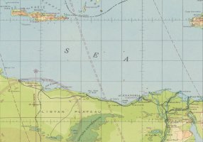
Here's an example of the Crete to Cairo one I made. Keep in mind this is only 1024x717 for posting here. The one I made with GeoViewer came out to about 6000 pixels across and is a GeoTIFF of about 92MB:

Crete-Cairo.jpg

With some work, this could probably be used with the new xml gauge, though I made this one a while back for Imperial Airways stuff.

Hope this helped! Now off to work for me!

Jorge
Miami, FL
 
I once had installed Golden wings, but this changed too much my sim and eradicated some modern sceneries and textures I wanted to conserve.
But flying in this older times is a nice alternative to modern flying with computered aircraft.
Hi Michael,

I don't think you need to give up GW at all. My main program is CalClassic's retro world. But I also use the GW version with the same FS. For this I have a separate scenery.cfg file as well as separate folders with aircraft, texture and addons. Depending on use, I rename the scenery.cfg file as well as the two texture and aircraft folders. Changing the latter would not even be necessary if all aircraft (retro and vintage) are in the same folder.

This works perfectly and there are no duplications. The renaming takes just some few secondes. Plus, I don't need to install tools like AF1, Instant Scenery or FSGWX twice.

Think about it again. It would be a shame not to use GW despite your interest in vintage flying!

BTW, I run FS9 with ten more such era-related installations.

Bernard
 
I agree with Bernard, but I had totally separate installs, each with their own aircraft. I also had a separate Ford Tr-Motor install, because I had scenery conflicts with that & my South African scenery. Instead of duplicating scenery installs, my installs could reference whatever scenery in whatever install I had.

I now just have 2x installs, my Silver/Platinum install, & my GW install.
 
Good evening friends,
just have landed at Berlin Tempelhof after an "IFR" flight from Koenigsberg.
They are funny these polish air controllers. the sended me at an altitude a bit critical for my old He 111 C,
after we agreed to lower flight lever there just came one more advice than blackout. I finished my flight with my own navigation.
Good to have old navigation cards LOL
Yes Bernard, the idea is interesting - little problem - I just ave anymore than 152GB of free disk space, If I fall under 150GB (the half of my disk)
on longer flights it happens my pc to "frozen"
Really happy to have this good old FS2004 which needs a lot less ressources than the followings sims
Best regards
Michael
 
Michael,

Try this main link: David Rumsey Map Collection

Now go to the search bar above and to the right of the web page next to the word "Share" and just left of the circle with the "by Maps" option. Make sure this option is the one selected.

Type "15328" in the search box and submit. It should take you to the collection for the United States Army Air Forces World Aeronautical Charts for WW2.

Now just click on the big, composite map and it should load up. It's the one labeled "15328.045" on the second row on my computer, but it's placement will depend on your screen resolution.

Give it a few seconds to load since it's fairly big (JP2 file is 1.1 gigs).

On the left side there will be an information section. Scroll down to the bottom until you see "Download 1" followed by "Download 2" near the bottom. The first one is for the georeferenced JP2 image, while the second is for the software for viewing and cutting.

Hover the mouse over the words, "Full Image Download ..." and click on it. Don't worry about the pop-ups. It should give you the option of saving the JP2 image somewhere on your hard-drive.

Do the same with the "GeoViewer For JP2 a..." option just below it as well. That one will take you to the site where you can download the software. There are two versions, one for 32-bit and the other for 64-bit.

That should be it.

I'm not sure why the other link did that, but my appologies. Sometimes you do one thing and get something completely different! :eek:

Hope this one works!

Jorge
Miami, FL
 
Good morning Jorge
thank you a lot for trying to help me,
but after about ten minutes the page almost was white - I supose my old XP pc is too old for that
Doesn't matter
I have been acustomned that there is a lot of things what are indegest for my old rig
Best Regards
Yours
Michael
 
Many thanks Jorge, it worked for me.
This map is perhaps not detailed enough for what I would need, but usable to do a gauge.
Michael, if you notice in all the collections the Germany map you need, let me know ;)

Cheers
Martin
 
Hi Martin,
as I replied to Jorge, the site do not work on my pc.
I searched all the time yesterday to find an usuable
"Luftnavigationskarte" but all I found was just un usable or it was to pay for.
At last I opened a thread in the forum of "Deutsche Luftwaffe Cockpit Instrumente" but until now I get no answer.
I'm really a "bit down". We can not work on the boat - it is toooooo hot. Outside my thermo says 36°C in the shadow and in my room I have
27.5°C, but it seems that this hot weather will change on saturday..
The He 111C 2D panel is close to be finished. I than will try if I can do something with the textures of the fuselage and the wings.
Best regards
Michael
 
Hello Michael
I'm now in Ireland and the weather is perfect, a spring sun ideal for us, I'm a bit afraid of what we'll find when back on Friday...
Ok, I'll have a look to see if I can find "luftnavigationskarte" on this site, and will let you know ;)
Cheers
Martin
 
On break and saw this.

Michael,

I went to webarchive and did a search for an old website and found this: Luft-Navigationskarte in Merkatorprojektion Blatt Deutschland vom Generalstab der Luftwaffe

Klein,

Yes, it's the old WW2 USAAF equivalent of a planning chart at 1:5,000,000 if I'm not mistaken. The scale is HUGE when compared to some of the other charts available (like the International Map of the World or equivalents which is at 1:1,000,000).

I was only using it, and what I could cut out of it, for flight segments and to get a general idea of what airports would be where since there is little information on many of the older/smaller ones -- especially in Africa and the Pacific areas.

There are some other charts I would love to use, but if there's a tutorial or "guide" on the xml for the gauge I could try a stab at it at some point.

To be honest, I had originally thought it would be possible to replace the background image of the default maps/gps with this, but somehow I don't think it is.

One of the nice things about living less than 10 minutes from work is that I can head home for lunch. Alas, it's back to work now for a few more hours.

Jorge
Miami, FL
 
Hello Jorge
I tried to explain what I understood on the xml code for the GeoLibre map, so you can re-use this code to fit to any map in mercator format you need, hope it helps.

Cheers
Martin
 

Attachments

  • Nord_Map.zip
    5.9 MB · Views: 3
Back
Top