KASH Boire Field Airport

tgycgijoes

Members +
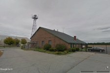
In checking VATSPY this morning, I noticed atc at an airport I had not heard of before and when checked on AIRNAV was surprised it was small though is a controlled airport. I am having more fun lately creating than flying so I checked to see if it has been updated payware or freeware and did not find it for FSX/P3D. Anyone here done it or decide to do it "this week" so I don't spend time that could do a different one? Let me know. I have all my Google Earth photos. I was going to use the default buildings but they just don't do it for me so I will be doing custom hangers in Sketchup and have found out how not to be frame hogs. I have three of my own created airports and even with a lot of AI I did with AIFP3 I am getting in the high 40s with the default fsx. and 30's with a Carenado Kingair. I am watching this for replies. :wavey:
 
I've started working

This afternoon I have begun working on KASH Boire Field, Nashua NH. I've got about 25% of the hanger models done in Sketchup. I used One-click Hanger and I really like it a lot. Experimented a bit with it this afternoon, too with scaling and got a good model I think of the FBO. Last one I did for today.

FBO Hanger.jpg
 
Be sure to clean it up

Lookin' good! I'm just delving into Sketchup myself. It sure makes things easy!
Google the "Clean-up" addon for Sketchup so that you can make your buildings Flightsim friendly. It makes a big difference once they are converted into bgl's with the frame rates.
 
The Tower Building

When I first started this project I just figured that an airport in Nashua NH with one runway and 5 taxiways can't be very complicated can it? THEN...I opened it up in Google Earth and it is really involved but I like the challenge. I started this yesterday and it needs a few tweaks but I wanted to be sure it worked in MDCx and then in FSX and not be surprised like I have been in the past. Here is a screenshot. There is lettering on the brick in the front but I can't read it. I telephoned the Tower but no one was there. I called the FBO and got a really receptive CSR there but he couldn't remember exactly what it said and couldn't leave the FBO unattended. He suggested that I call the tower on Monday and ask them for help. Then I will open it up - put on the lettering and the antennas on the top of the control tower. If you look closely you can see the coffee bar inside through the big glass wall. Its all done The Tower Building.jpg
in Sketchup 2016 even adding the coffee bar. It was just too empty in there with all that glass. All of this is done by hand (except the coffee bar and the railings).
 
That is it

I looked and looked but couldn't find anything online just a lot of aircraft photos on their facebook pages. Thank you for that. I will add the type to the field side which this is. You don't happen to have nice shots like this of the other side do you? That is the blurry Google Earth parking lot side I need too.
 
I looked and looked but couldn't find anything online just a lot of aircraft photos on their facebook pages. Thank you for that. I will add the type to the field side which this is. You don't happen to have nice shots like this of the other side do you? That is the blurry Google Earth parking lot side I need too.
I believe the other side simply says "Aviation Center". I could make out "Center" but the other word was blurred enough I couldn't figure it out, until I saw this pic.

Addendum: Here's a shot of the parking lot side and maybe I was wrong here. Looks like this side has nothing on the Tower:
 
Where are you getting these shots

I believe the other side simply says "Aviation Center". I could make out "Center" but the other word was blurred enough I couldn't figure it out, until I saw this pic.

Addendum: Here's a shot of the parking lot side and maybe I was wrong here. Looks like this side has nothing on the Tower:

This gives me a good shot of this side. I wish Google Earth had nice street shots like some do but no such luck. The shot I need is cut off from the left of this photo. It is on the brick wall that is part of the front not visible here. I do really appreciate you posting these. I will be doing updates today but I also think these shots are perhaps older than Google Earth has (2020). Any idea from your info where the airport beacon is located on the field? I could not find it on the architectural drawing which is really fantastically detailed dimensions and all. Every building is individually identified. I am going to call the field on Monday morning which the FBO said to do and ask them if you don't have any shots of that front parking lot side brick wall.
 
A few more, I did not see any obvious Airport Beacon, but it may be on the tower roof, I just couldn't tell for sure: The first image shows either an AWOS or ASOS (can never remember the difference, lol) I have one of what is pictured. . .made it for one of my airports.
 
Found this if it's any help...

Small letters may possibly be (I'm guessing here): "Nicholas N. Tamposi"

Large letters are: "Aviation Center"
"Daniel Webster College"

The OMS
 

Attachments

  • 19432968-19432968.jpg
    19432968-19432968.jpg
    25.3 KB · Views: 402
Thanks Again

A few more, I did not see any obvious Airport Beacon, but it may be on the tower roof, I just couldn't tell for sure: The first image shows either an AWOS or ASOS (can never remember the difference, lol) I have one of what is pictured. . .made it for one of my airports.

Just did some tweaks to the tower building and thanks to Old MSgt below I will see about the front of the brick. I may wait until Monday when(if) I get to talk with someone in the tower and see if now that Daniel Webster College is closed and sold if they are or have taken off some or all of the letters off the tower building. I'll post here on Monday if I can get an answer to that. Thank you all for your help and photos. I will continue to make the minor changes to the building that I have seen from these.
 
This gives me a good shot of this side. I wish Google Earth had nice street shots like some do but no such luck. The shot I need is cut off from the left of this photo. It is on the brick wall that is part of the front not visible here. I do really appreciate you posting these. I will be doing updates today but I also think these shots are perhaps older than Google Earth has (2020). Any idea from your info where the airport beacon is located on the field? I could not find it on the architectural drawing which is really fantastically detailed dimensions and all. Every building is individually identified. I am going to call the field on Monday morning which the FBO said to do and ask them if you don't have any shots of that front parking lot side brick wall.

Beacon is near/on the very last building at the south end of the airport near the threshold of Rwy 32.
Link to the FAA airport diagram (pdf) also shows the height: http://aeronav.faa.gov/d-tpp/2106/05036AD.PDF
 

Attachments

  • KASH Beacon 2.jpg
    KASH Beacon 2.jpg
    473 KB · Views: 396
If I had something to drive other than my company work truck, and I had the time this weekend for a road trip, I'd go get you some shots. Nashua is about 3 1/2 hours from me.
 
OK and thanks both

Thank you for both of those photos. I went back to the Jeppsen Airport Chart and I can see a "star" at the last building by Runway 32 and a height of 245 which is 45 feet higher than airport elevation so I would say that tower is 45 feet high. You can see a tower in Google Earth but again blurrys. I will add that later to the ADEx layout. Keep the "cards and letters" coming and this will be as accurate as we can make it and I will be sure to share here. I am going to Office Depot on Monday and get a decent copy 17x22 of the architect's drawing.
 
that is above and beyond

If I had something to drive other than my company work truck, and I had the time this weekend for a road trip, I'd go get you some shots. Nashua is about 3 1/2 hours from me.

Thanks for you offer. I am going to see if someone at the airport will take some "phone shots". I did a West Virginia airport a few years ago and a very nice young lady in the FBO shot a dozen for me of the back of the buildings not visible at all on Google Earth. Sometimes Facebook pages give really good shots but the flight schools just shot their planes and grinning "solo's". If the person you call is not grumpy that day they are usually amazed with what we do.
 
Finally got an answer

Yesterday with the exception of the lettering on the tower building I completed it and was able to create a bgl for ADEx. It looks great on the field IMHO. I also went to Office Depot in town this morning and got the pdf of the architectural plan enlarged to a bigger size to be able to read it and start with placing the hangers I have done so far.

Well, this morning I started my quest about the letters on the tower building. The first call to the Airport director still got no answer so I left a message but I am too impatient so I started looking for links on their website. There are 18 businesses at the airport listed with telephone numbers and I started at the top. After 6 "no answers" I got a very helpful pilot at Nashua Jet Aviation to give me a definitive answer: "with Daniel Webster College closing, all the lettering has been removed from the tower" so with my tower now complete it is ready for final placement on the airfield.

KASH Tower Front From Parking Lot.jpg

Tower Bldg Back Side.jpg

I want to thank all of you who took the time to help with this and I am off to the "construction site" to work some more on Nashua Boire Field buildings.

:running:
 
Today's Update

I got a telephone call this morning from the airport manager. He confirmed that they DID remove the Daniel Webster College lettering but he was not sure if anything else was put up and is going to send me some photos. I found this photo on a news site so this may be what is up there now:

AirportA-1100x733.jpg

I am going to leave it blank until I get visible confirmation of what is actually on the tower as of now.

Finished up 8 hangers and the FBO Hanger after dinner. Here is a shot on FSX of them. Tomorrow I will do the rest of the FBO and the East Coast Aero Club building which is attached. I found out how to get "on the ground" with photo quality not the blurries that Google Earth does on the street and took 20 shots of so of everything I could for reference.

Image_210628_202941.jpg

Also created a photoreal background under the airport with SBuilderX (64bit) which is really cool. I used it a year or two ago and had to refresh my memory how. When I added it to the FSX airport scenery for KASH, top down showed that the airport co-ordinates in FSX were a bit off so I corrected that with a background shot in ADEx and now the runway/airport is exactly where it belongs aprons, taxiways and all. I did the photoreal background because Google Earth shows all kinds of residential areas and FSX is nothing but forest all around the airport. Looks so much better I think now. I am looking forward to sharing this with everyone. Creative juices are flowing again and its fun.
 
Back
Top