Screenshots!

Sticking with the Bells, we take a 407 commute to New York.
Surprisingly there is only one heliport at KJFK.
Plenty of shipping traffic out of New York Harbour as we approach the East River

Bell 407 2.png

Iconic Brooklyn Bridge, Lady Liberty: welcome to New York.

Bell 407 3.png

And a quick change of coat courtesy of NYPD, a RW weather tour of the city wearing a snow blanket, as seen today

Bell 407 10.png
 
Fifty years young, and nothing wrong with taking a Bell 222 (Cowansim again) to Lord Howe Island for the weekend.
Slightly further than normal 700km range, but we turfed a couple of pax for a pair of tanks.

Bell 222 (4).png

No time for sightseeing, we have a near 4-hour trip ahead

Bell 222 (8).png

...to Sydney. We will overfly to YSSY and Uber in to town for the evening.

Bell 222 (9).png
 
I posted this in the MSFS 2020 Forum, but really it belongs here.
Rotorheads will appreciate the touch needed for trainspotting, a pity the sim has (very) limited opportunities for this.

 
The Sikorsky (Now Erickson) S-64 Skycrane needs no introduction: it lifts 10 tonnes.
There are 100 of them, surprisingly each has a Name.

1.png

Often found in forest fire suppression operations, it can fill the 10,000l tank in 45 seconds with its snorkel.

S 64 4.png

4.png
 
Last edited:
I spent the afternoon trying to find suitable helos for the Scottish Reel event and have a short list of nicely behaved helos now and a shorter list of helos that do not want to play nicely with my P3D helo autopilot! :dizzy:

I have two helos that have engine issues while on AP and keep surging in RPM and then dying to nothing which makes for a very bouncy ride and one helo that refuses to go into altitude hold and just loses altitude whenever the autopilot ALT HOLD is engaged. I will have to revisit the config files to see what is going on as all three perform well in FSX.

On the plus side I did get to see some interesting ships on my travels around the New England coastline.

First up was the USS Niagara Sail Training ship while I was testing the ERS Bell 222.

Chopper_1.png

The next one I came across was the Maersk Djibouti container ship with a full load of 'sea cans' while I was testing the now freeware Milviz MD530.

Chopper_2.png

It was a fun afternoon of chopper testing and ship spotting!
 
I picked up another new helo the other day and spent some time this afternoon giving her a test flight in P3D. I was wrapping up my usual testing flight plan of short hops around a bunch of New England airports when I spotted this beauty sailing down the Long Island Sound so I had to take a closer look.

The USCGC Eagle in all her glory.

Chopper_3.png
Chopper_4.png


It was a fun afternoon! :cool:
 
Is there anywhere a helicopter doesn't make life easier?
Here we go down the road from McMurdo Station to Scott Base, Antarctica

Scott Base.png


...and here's that Chinook again

Chinook.png
 
Last edited:
Rob (my online flying buddy) and myself have been flying helos in the Indonesian island chain for a few nights now. It's been fun exploring the many volcanoes in the area but last night's flight got a bit 'white knuckle' towards the end. The leg had started well but the WX at the destination closed in while we were en-route (we always fly with Active Sky real WX regardless of what it throws at us) and by the time we arrived it was diabolical.

The airport (WICC) was at roughly 2,500 ft ASL and located on a plateau between two volcanic ridges and the approach is tricky in good weather, in bad weather it was horrendous. The low cloud base was way lower than the airport so I stayed above the fog/cloud layer for as long as possible but eventually I had to go into it because I was very low on fuel and there were no other airports in range that had fuel (yes I could have cheated and refueled in flight but where is the fun in that!) At about 3,500 ft everything went white and I was in full IFR mode, thankfully the helo autopilot I use in P3D is very easy to use and accurate so I was able to track my progress laterally in Little Navmap and I was descending in 100 ft increments while looking down most of the time trying to spot obstacles.

As I got to the town I suddenly started seeing apartment building's flat roofs passing under me with a clearance of about 50 ft (I still had zero forward vision)! I held my altitude at that point and slowly edged towards the airport just hoping I didn't find a taller building or a radio tower. When Little Navmap showed that I was over the runway I figured it was safe to go down again and when my helicopter call-out gauge announced 30 feet the runway markings popped out of the fog ... phew! I was then able to hover-taxi my way over to the fuel pumps thanks to little Navmap again.

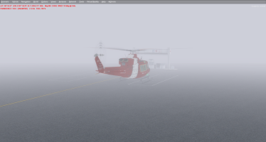
It was a tense landing and I wasn't sure I was going to get down at all. Here's a shot I grabbed at the fuel pump when the fog lifted slightly, when it closed in I couldn't see the pumps at all that's how bad the visibility was!

WICC_Cloud.png
 
Back
Top