• There seems to be an uptick in Political comments in recent months. Those of us who are long time members of the site know that Political and Religious content has been banned for years. Nothing has changed. Please leave all political and religious comments out of the forums.

    If you recently joined the forums you were not presented with this restriction in the terms of service. This was due to a conversion error when we went from vBulletin to Xenforo. We have updated our terms of service to reflect these corrections.

    Please note any post refering to a politician will be considered political even if it is intended to be humor. Our experience is these topics have a way of dividing the forums and causing deep resentment among members. It is a poison to the community. We appreciate compliance with the rules.

    The Staff of SOH

  • Server side Maintenance is done. We still have an update to the forum software to run but that one will have to wait for a better time.

TFFS Les Saintes Terre De Haute Aeroport Guadalupe

tgycgijoes

Members +
Hey Gray Eagle, you'll be excited to know that I am working on a new airport for my interCaribbean VA because the only one available is MSFS and I can't convert it, so I'm making it with Google Earth. Pretty little airport which is where I parked the Super Stearman last night at the default version. It needs some sprucing up with a few Sketchup buildings and ground poly. Stay tuned for screen shots.
 
I spent the whole morning and the afternoon refreshing myself how to create photoreal scenery with SBuilderX and was successful after a few hours of frustration. I got what I went after:

TFFS Photoreal background.jpg
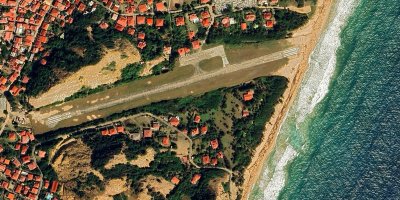
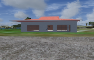
Isn't it beautiful? Well from up above it as all photoreal background is. I know how to use the autogen annotator to place trees and buildings but unfortunately there are no red tile roof houses in it. Trees would be ok. I think it would defeat the purpose to use other kind of houses. So, no photoreal after 5 hours. I was able to create groundpoly textures of old beat up concrete like it is as you can see here and also created the center lines and threshold stripes with the gp line tool. Yesterday and this morning I completed the terminal. It is 25% accurate in that there is only one side accesible from Google Earth Street view as is usually the case, so I "fudged" the other three sides. The dimensions and roof tiles are all correct anyway. Here is what I have so far. I'm tired so that's enough for today.TFFS Terminal Bldg and apron.png
 
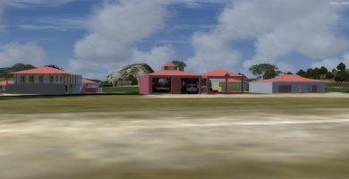
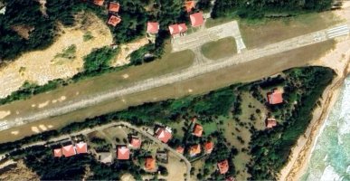
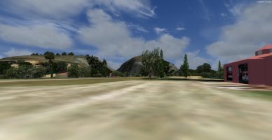
I have the airport complete with a photoreal background. I placed some custom houses, terminal and firehouse and will try to place autogen vegetation and houses with the annotator. I have done this in a few years so we'll see what happens. Here are two screenshots in Prepar3D V4.5 using ORTFFS Terre De Haut Airport and Bldgs.jpgTFFS Terre De Haut Airport Topdown Photoreal.jpgBX BOB. You can see in the photoreal background bgl from Google Earth and SBuilderX the runways numbers in white and the faded ones where they were repainted and never totally covered up. I found photos of the airport online from 1995, 2008 and 2014 which are the latest photos. This Google Earth is from 2025. The runway, taxiways and apron have not been kept up because of IMO no traffic using the airport. According to Tour Guide Sites this is a really beautiful island but tourists use the ferry from Guadalupe where they land at that large airport.
 
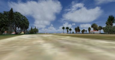
Here's what I did after dinner tonight...I have to add some more of the custom buildings. I learned how to use the autogen and generated buildings but none of them were any good none of them being Caribbean like my custom ones so I deleted them. Then I redid the photoreal background and generated autogen vegetation I am pleased with. It's not difficult once you get the hang of it. I printed out 21 pages of instructions to follow but didn't need them after a few minutes. P3D doesn't have the exact trees so I had to settle but I think they look pretty good anyway. A Mediterranean mix. Here are two screenshots:

On the apron at TFFS with autogen.jpgLooking West from the terminal at TFFS.jpg
Going to take a walk down the beach into Terre Des Haute and relax.
 
Made seven simple Caribbean houses from online photos with really low impact on frame rates (only 15-17KB each) that I am going to place on the photoreal background to complete this tomorrow. I figured out how to use the Autogen Annotator to make and place buildings but none of them remotely look like what they should so I made these from scratch in Sketchup today. It is a lot more work but I feel it will be worth it. It will look like it is supposed to. Prepar3D's default landclass is not really close at all. There are no houses or vegetation where it should be. Probably goes all the way back to FS9 I'm guessing. I will finish it and post screenshots and a link to it with all the custom bgl's.
 
Yesterday I worked all day to finish this up. Although I got all the houses in place and they look good in P3D, the cemetery I found in the 3D Warehouse was way too large (over 15MB) and as such, ADEx would not accept the bgl after I compiled it in Model Converter X, so I deleted it. I went onto Google Earth and on the street view next to the cemetery I could see the crypts plainly,and created a selection of them in Sketchup so it is now accurate but when I placed them, I had a problem with elevation so I quit yesterday at 6PM and I am not sure I will get back to it today with stuff going on here at home. If I DO, then I will send it out to my testers and if there are no problems to fix, then will probably be able to share it Monday with you all. I will put this one on AVSIM and also in our Resources since there isn't ANY accurate version for FSX or P3D versions, only X-plane and MSFS and neither of them IMO is accurate enough. Not bragging but they took license in some areas I didn't.
 
Yesterday I worked all day to finish this up. Although I got all the houses in place and they look good in P3D, the cemetery I found in the 3D Warehouse was way too large (over 15MB) and as such, ADEx would not accept the bgl after I compiled it in Model Converter X, so I deleted it. I went onto Google Earth and on the street view next to the cemetery I could see the crypts plainly,and created a selection of them in Sketchup so it is now accurate but when I placed them, I had a problem with elevation so I quit yesterday at 6PM and I am not sure I will get back to it today with stuff going on here at home. If I DO, then I will send it out to my testers and if there are no problems to fix, then will probably be able to share it Monday with you all. I will put this one on AVSIM and also in our Resources since there isn't ANY accurate version for FSX or P3D versions, only X-plane and MSFS and neither of them IMO is accurate enough. Not bragging but they took license in some areas I didn't.
First of all, how and why did you manage to locate such a remote location as you have? I've been to Virgin Islands via USS Forrestal on workups
prior to Med cruises, and Jamaica as well but had no knowledge this place you are creating for P3D existed. I can remember on our workups,
when cruising off the coast of San Juan Puerto Rico on our way back to Mayport FL. It was at night and the sky was a velvet back with the beautiful
twinkling lights of San Juan passing by. We must of been cruising 20 Knots and I was on the forward port catwalk with my radio listening to Steely Dan and "Peg" at the time. What fond memories. :)
 
It will only be accessible by the "Twotter", equivilent or smaller aircraft. I found it on accident when I had planned a flight from TBPB to TAPA but after about a half hour of flying and checking the GPS I saw that there was over 2 hours to go and I didn't have the time to complete it. I wanted this to be realistic and not just ESC and quit so I checked the map and saw that I was close to here and Guadalupe which has the large airport. Since I was in the Super Stearman I didn't want to deal with Guadalupe so I chose to land here. It IS in Prepar3D V4.5 but the typical "default" style airport with a couple of autogen buildings and simple runway.

I searched online for a "real" version and there was not one at all except what I mentioned above. So it did not look difficult to do and I just downloaded a lot of photos; took Google Earth screenshots and created everything in Sketchup 2017 and placed it. It has a photoreal background from SBuilderX and all the vegetation of the PR is by Autogen Annotator which I re-taught myself after three years of not using it. I have been in the Atlantic Missile Range which is where you were on Forrestal (I was on America's ORI there and liberty on the US Virgin Islands) but the only way to get on the island is this little airstrip by charter or by boat from Guadalupe where the cruise ships dock. For vacationers, it's a true paradise. You can get a lot of info about it online from travel sites which I did so I knew about it. Since it did not "realistically" exist in the Prepar3D/FSX world, I just decided to create it and share.

I created a lot of small airports in the U.S. this way...they did not accurately exist so I made them. Did a half dozen in Alabama and a few in Texas this way. They are all documented in threads here in the "Outhouse".
 
I sent the airport over to Gray eagle to test for me and he came up with a huge problem that I will just chalk this one up to experience on learning autogen annotator again. The problem is if you don't have ORBX Global and Vector installed the airport doesn't work, it's distorted so since I have them, I will probably leave it on my system since it is more accurate than the default one. If anyone wants a copy if you have the ORBX on your Prepar3D, PM me and I will happily send you a zip copy. I am not going to post it. That's all for this one. Back to flying interCaribbean from my other airports. Sadly, very disappointing, but c'est la vie.
 
Back
Top