michaelvader
Members +
Good evening friends
does someone use FSearthtiles or an equivalent program in FS2004 for scenery making?
The reason for this questions is:
1. The original fs9 ground scenery of the area where I live is total fantasy
2. I want to look it more realistic
3. I have FSEarthTiles but a) I do not know to use it
b) Google earth is no longer on my PC, I tried different downloads and installations
but failed, seems it does no longer agree with my old Windows XP computer
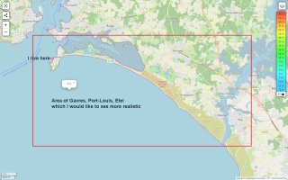
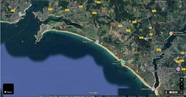
4. I would know which are the scenery tiles concerned by the area I live (Gavres at the east side of the Bay of Lorient)
I landed with my chopper in what I supose to be the center of the area the coordinates are:
N47* 41,47 / W2* 21,29
The area concerned is at the south La Pointe des Saisies / at the north the north west side of Port Louis
at the west la Tourelle des Trois Pierres / at the east the region around Etel
5. a) So can some one tell me an alternative to get Google earth work on my old pc?
b) or can some one point me to an alternative solution?
c) or can and would some one make me the tiles to replace
I tried to contact the site of France VFR but never got an answer
If some one will have more informations I can try to make a photo copy of a Jeppesen navigation chart and marke the areaa concerned
Best regards
Michael
does someone use FSearthtiles or an equivalent program in FS2004 for scenery making?
The reason for this questions is:
1. The original fs9 ground scenery of the area where I live is total fantasy
2. I want to look it more realistic
3. I have FSEarthTiles but a) I do not know to use it
b) Google earth is no longer on my PC, I tried different downloads and installations
but failed, seems it does no longer agree with my old Windows XP computer
4. I would know which are the scenery tiles concerned by the area I live (Gavres at the east side of the Bay of Lorient)
I landed with my chopper in what I supose to be the center of the area the coordinates are:
N47* 41,47 / W2* 21,29
The area concerned is at the south La Pointe des Saisies / at the north the north west side of Port Louis
at the west la Tourelle des Trois Pierres / at the east the region around Etel
5. a) So can some one tell me an alternative to get Google earth work on my old pc?
b) or can some one point me to an alternative solution?
c) or can and would some one make me the tiles to replace
I tried to contact the site of France VFR but never got an answer
If some one will have more informations I can try to make a photo copy of a Jeppesen navigation chart and marke the areaa concerned
Best regards
Michael

 I don't remember if they also included coast lines?
 Right-click to download the zip file(s), unzip the BGL(s), install in your favorite scenery folder (I use Addon Scenery> Scenery, start FS.