-
Please see the most recent updates in the "Where did the .com name go?" thread. Posts number 16 and 17.
-
IMPORTANT DOWNLOADING INFORMATION - ALL MEMBERS PLEASE READ
Please see this thread for updates. Update Thread
SOH ADMINISTRATION
You are using an out of date browser. It may not display this or other websites correctly.
You should upgrade or use an alternative browser.
You should upgrade or use an alternative browser.
CBI Scenery Project
- Thread starter UncleTgt
- Start date


UncleTgt
SOH-CM-2026
Some of you might have wondered why I stopped before reaching Cox's Bazar...
Well, that's in a whole new country... ... & it would mean going further up the coast too...


Mind you, it would be nice to have somewhere to fly Acwai's "Twin Dragons" P-38's from , & they flew out of Chittagong.
Well, that's in a whole new country...
... & it would mean going further up the coast too...Mind you, it would be nice to have somewhere to fly Acwai's "Twin Dragons" P-38's from
, & they flew out of Chittagong.UncleTgt
SOH-CM-2026
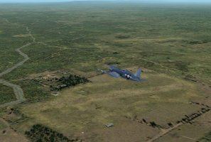
Just north of Chittagong field was Double Moorings.

In operation from mid-43 onwards, this field was mainly used by the squadrons of the newly-created Indian Air Force.
Here's a shot showing both locations at the mouth of the river - Chittagong town was a little further up river (to the right).

In operation from mid-43 onwards, this field was mainly used by the squadrons of the newly-created Indian Air Force.
Here's a shot showing both locations at the mouth of the river - Chittagong town was a little further up river (to the right).


Shadow Wolf 07
SOH-CM-2025
Outstanding work!
UncleTgt
SOH-CM-2026
Thanks guys. I'm just trying to garner some interest for a neglected part of WWII's air campaigns, especially from prospective mission creators.
It was a tough slog from both the RAF & IJAAF perspectives.
After the initial sweeping moves, IJAAF assets were often outnumbered & so often resorted to tip & run type operations or fighter sweeps, redeploying to safer rear area bases in Singapore, Malaysia, Vietnam & Thailand after ops & just using many of the Burmese strips as forward operating bases.
RAF assets suffered from a slow build up of numbers, often of "second class" aircraft types. Similarly they also suffered from a slow development of bases across India from which to base any offensive operations.
The Arakan campaign of '43 taught the RAF some hard lessons, as the Hurricane sqns suffered at the hands of superior quality pilots equipped with tight turning Oscars.
It was only after the final IJA gambit was broken at Kohima/Imphal/Admin Box in the spring of '44 that Allied air power truly began to transform the ground war, especially with the innovation of air supply techniques.
UncleTgt
SOH-CM-2026
For any advance back into Burma through the Arakan coast, a whole infrastructure needed to be built closer to the border. The road wasn't a road at all, it was little more than a track, & there was nothing south of Chittagong for aircraft to use.
Nonetheless, the coast seemed the "easiest" route so through the 2nd half of 1942 a myriad of advance landing grounds were created between Chittagong & the Burmese border. Later these would include a handful of strips inside the border itself, & this hotch-potch of landing grounds were added to again for the 1944 offensive.
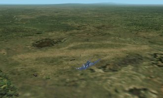
Approaching Cox's Bazar from the West

And overhead the town itself, looking West

Nonetheless, the coast seemed the "easiest" route so through the 2nd half of 1942 a myriad of advance landing grounds were created between Chittagong & the Burmese border. Later these would include a handful of strips inside the border itself, & this hotch-potch of landing grounds were added to again for the 1944 offensive.
Approaching Cox's Bazar from the West
And overhead the town itself, looking West

UncleTgt
SOH-CM-2026
Ahem, that should be "Reindeer"
Moving on, just East of Cox's Bazar & between it & Ramu, we had, by 1944, 2 more strips, Jumchar & Lyons.

To the NE of Cox, & N of Ramu was Jaori

& midway between here & Dohazari they built Chiringa.

Just to South of Ramu was Hay.

Moving on, just East of Cox's Bazar & between it & Ramu, we had, by 1944, 2 more strips, Jumchar & Lyons.
To the NE of Cox, & N of Ramu was Jaori
& midway between here & Dohazari they built Chiringa.
Just to South of Ramu was Hay.
Attachments


UncleTgt
SOH-CM-2026
I did a back-dated layout for Chittagong, so there will be 2 sets of airstrips & gsl with the next package, one for late '42/early '43 (First Arakan offensive), & one for late '43/ early '44 (Second Arakan offensive - Battle of the Admin Box).

Chittagong in early '42 would be even more spartan. After the Japs raided it it was abandoned & the air assets decamped to Comilla. As Chittagong would be the only strip in an early '42 set for this area (not even a runway at Cox's Bazar until the end of the year!), I decided it just wasn't worth the effort.
Similarly, I decided against doing Hathazari. It wasn't operational until the end of 1944, & by then much of the action had moved on...
UncleTgt
SOH-CM-2026
Ahh, the mouth of the Ganges!!!
And with it, a whole new set of challenges.
First, the river mouth to the top right of the screengrab below is the River Feni. It's all-new, as since the War it's been blocked by a dam...

Looking Nw from the same location we have the all-new approaches to the small port of Noakhali. This town doesn't exist anymore - it was washed away by the Ganges in the '50's, & it's channel has been filled in by sediment as the mighty river changes it's path to the sea. This is mud-moving on a whole different scale , as the mesh reflects the modern era.

I suspect I'll have to make some compromises as we move up river, away from the coast, if only to keep the whole thing manageable ...
...
And with it, a whole new set of challenges.
First, the river mouth to the top right of the screengrab below is the River Feni. It's all-new, as since the War it's been blocked by a dam...
Looking Nw from the same location we have the all-new approaches to the small port of Noakhali. This town doesn't exist anymore - it was washed away by the Ganges in the '50's, & it's channel has been filled in by sediment as the mighty river changes it's path to the sea. This is mud-moving on a whole different scale
, as the mesh reflects the modern era.I suspect I'll have to make some compromises as we move up river, away from the coast, if only to keep the whole thing manageable
...highpockets
SOH-CM-2025
Hiede
I have been AWOL, I assume you are reworking Talon's missions ,which I have. Will your work be available when finished?
I have been AWOL, I assume you are reworking Talon's missions ,which I have. Will your work be available when finished?