CFS3 Terrain Creation - is anyone still around?

Ah so you have made mesh and water and begin flying along your coastline and you see terrain pop up where there should only be water. Annoying isn't it.

In the past I have used 2 methods of getting rid of the unwanted terrain in the water. In Global Layer I have used the flattening Terrain option to remove small areas of terrain and I have also used a blank facilities file for other small areas of terrain. Kinda like whack a mole.

This time I have taken a different approach with PNG because of the amount of islands and potential of many terrain pop-ups.
Still used the global layer flattening process, loaded the elevation.bil file and the ocean.shp or water.shp file (ocean-water files without lakes) into the software.
Select the water area and then right click and select TERRAIN create/flatten terrain from selected area features. This will create a triangulated grid layer. It will take awhile for the process. Then select only the elevation.bil and triangulated grid layers. Export a new elevation.bil file using the original coordinates you used to make the original elevation.bil file. Don't use the coordinates you entered into the math.xls file.
Run your new elevation.bil file in make mesh process and then place new mesh files in your theater. Back-up your original mesh files.
 
Last edited:
Some times its just good to talk to one self. So here goes, some random thoughts.

Since Diva Gis and Web Gis are error 404 and unavailable for shape files, I have found the Natural Earth is a good source. The files seem to be very accurate.
Been messing with Qgis in my spare time and find it has oodles of plug-ins and lots of knowledge out in the web via written how-tos and videos.
I like the capability of checking the validity of shape files and when found sometimes can be fixed in the program or gives an error report that shows where the problem is. Did I mention that the plug-ins are fantastic?
Cheers
 
This is Way above my pay grade ! Fantastic the we still have people working on CFS3 to make it better for us fans. Thank you so very much. Regards,Scott
 
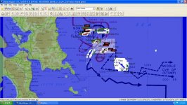
One thing I like with global mapper is the ability to place the theater mission map in the program and then also historical maps with coordinates.
Then set up way points for missions based on the historical information.
Example of Leyte Gulf.jpg
 
One thing I like with global mapper is the ability to place the theater mission map in the program and then also historical maps with coordinates.
Then set up way points for missions based on the historical information.

you are probably aware QGIS can also do this
 
No I hadn't reach that level of expertise with Qgis yet. Most familiar with global mapper so I carry on with using it. I have a double boot and as long as my win 64 pro continues to function I will keep using it.:)
 
Did I ever mention that I dislike having to create roads in a theater when the existing shape files have lines on top of each other?
one week down and another to go.
Philippines_Roads.jpg
 
In the Philippines, both the roads and railroad shape files from open street maps had lines on top of one another which just stops the make vector processes crash. Had to hand draw all the roads.

Found better railroad shape files at Natural Earth.

Was having some problems running vector ai-pathing and exclusion of the shipping lanes. Steve was able to help me out.

In Papau New Guinea, ran flatten the terrain process in global layer, it looks like I still had some elevations above 0 in the water areas. Will re-run make mesh tomorrow.

Oh, in RS China, it is now bundled up in a installer, just need to test the install in my win 10 harddrive.
 
Last edited:
For those that have global mapper I have attached custom ship symbol files that you can add to GM. I created a folder in GM called Addon Symbols and placed these symbols in the folder.
capture_001_04072024_113332.jpg
 

Attachments

  • GlobalMapper Add on Symbols.zip
    19.5 KB · Views: 2
Anybody here that's worked on the landclass xml? The MAW landclasses xml only call for one variation mosaic for each landclass type, eg

<LandClass Id="5" Name="Grassland North" Dim="9216" Priority="10" IsWater="No" Mask="med_genericlandclassmask.xml">
<Seasons>
<Season Name="Summer">
<Variations>
<Variation Mosaic="006summer1.mos" Scenery="006summer1.lso"/>
</Variations>
</Season>


if I add a second variation mosaic then I only ever see the second one and not the first in game

<LandClass Id="5" Name="Grassland North" Dim="9216" Priority="10" IsWater="No" Mask="med_genericlandclassmask.xml">
<Seasons>
<Season Name="Summer">
<Variations>
<Variation Mosaic="006summer1.mos" Scenery="006summer1.lso"/>
<Variation Mosaic="006summerI1.mos" Scenery="006summer1.lso"/>
</Variations>
</Season>


Is there another file that controls this? I several variations called in default cfs3 xml.
 
I have heard that there is an issue with the lcf tool. The WOFF/WOTR has figured some sort of fix to it I think to create their scenery.
 
I have heard that there is an issue with the lcf tool. The WOFF/WOTR has figured some sort of fix to it I think to create their scenery.

maybe thats it? was hoping for a bit more random variation than one mosaic per landclass. perhaps several sub variations can be made per landclass but it feels like more work :ROFLMAO:
 
Terrain tiles of a given land class, when properly done, are tessellated, so the different variations line up seamlessly in any random combination. So if this were done, even though the variations can't be combined into one land class, there could be variations of the landclass itself, each with only a single variation, e.g. CropsAndFields1, CropsAndFields2, etc. The randomization done in the landclass file would need to be created by the builder in the lcf file.
 
there could be variations of the landclass itself, each with only a single variation, e.g. CropsAndFields1, CropsAndFields2, etc. The randomization done in the landclass file would need to be created by the builder in the lcf file

thats pretty much what im thinking (y)
 
The RGN2LSO tool that I downloaded off this site is broken. I found info on some changes that have to be made to the input code, but that still didn't fix the problem.
I read some time back that some forum member made a fixed version that seems to be unavailable anywhere on the net.
 
The RGN2LSO tool that I downloaded off this site is broken. I found info on some changes that have to be made to the input code, but that still didn't fix the problem.
I read some time back that some forum member made a fixed version that seems to be unavailable anywhere on the net.
Thank you. What changes were suggested for input code?
 
The info was recorded in one of the many tuts or instructional posts that I downloaded when I started this project, so I can't remember where I saw it. If I come across it I'll let you know.
 
Back
Top