• Warbirds Library V4 (Resources for now) How to


    We just posted part one of the how to on uploading new files to the Library. Part 1 covers adding new files. Part 2 will cover making changes to your the uploads you own.


    Questions or comments please post them in the regular forums. Which forum is that... Well it is the one you spend the most time in.

    Thanks the Staff

    Library How to

CFS3 Terrain Creation - is anyone still around?

the river texture could possibly be repainted as an alternate shoreline without surf and the vector placed along the shoreline

yeah rivers are a bit of a problem but your idea may work. Is there a river shoreline with alpha channel to be borrowed from somewhere?
 
In the past I have always processed the lake water and ocean water together. In the future it may be possible to do them separately. In RS Sino major rivers were also processed with the lakes and ocean as area vectors.

In GlobalMapper I have a shoreline layer and a coastline layer. The coastline layer vector define the ocean, harbors, and large rivers.(its a continuous line) The shoreline layer defines those areas that you want to have surf. (It doesn't have to be a continuous line around your water features.)

An interesting thing I found while searching the files I found a texture called reef which I have a vague memory that I was going to add a reef in certain areas of Pearl by means of the vector process by re-doing railroads, roads, rivers, etc.

Thanks Andy for that info. I wish I knew more about Ankor's add on. It would be ideal to integrate that into the build, or maybe best to add after. I don't know I just don't have the capability right now to understand it and include it.

River line vector textures have the shoreline as part of the river texture. It should be possible that a shoreline texture for lakes and major rivers can be processed in the vector processing with rr, roads, etc. Just use the vector line(shoreline) of the lake and river area vectors.
 
Last edited:
yeah rivers are a bit of a problem but your idea may work. Is there a river shoreline with alpha channel to be borrowed from somewhere?

oh wait, I remember the water mask will end up on top of this new vector shoreline creating a sharp water edge unlike the existing shoreline which lays on top of the water mask. Maybe someone knows a way around this??
 
hmmm. Maybe if the vector is placed landside the water line on a second line. Will have to experiment on how much away from the water line and the width of the vector. Not sure how to generate that second line easily without having to do it one point at a time.....yet


oh wait, I remember the water mask will end up on top of this new vector shoreline creating a sharp water edge unlike the existing shoreline which lays on top of the water mask. Maybe someone knows a way around this??
 
Last edited:
what lies unknown

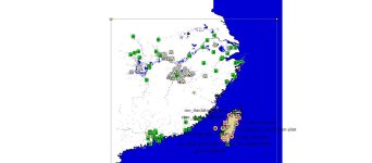
Oh my word! gold! I can't believe I find this global mapper workfile on a hard drive which was part of a broken bootable raid and sitting in a drawer.

There are some missing elements to the file such as the topos, and dems used to create RS China.

The file includes streams, rivers, lakes, interior islands, shorrelines, ocean water, airfield and installations gl entries, etc. There is enough elements there that one could use to it further development if necessary in the future.
 

Attachments

  • sino,china.jpg
    sino,china.jpg
    68.8 KB · Views: 43
Yes Steve, China is basically finished, however it might come in handing if at some point if one wanted to add additional roads, railroad track, etc.

I don't know how this 30x30 1 arc mesh is going to work out for the PNG. Its still being processed after over 14 1/2 days. Still in 0256 resolution with 0128 mesh files still to go.

I have started to look at alternative dems just in case. If required it will mean redoing most of the shapefiles already finished.

So in the mean time I am working on squadron and aircraft lists with airfield locations.
 
I don't know how this 30x30 1 arc mesh is going to work out for the PNG.

you should be able to use the same DEM and run ers2tiff with a lower resolution . I'm sure that will run a lot faster. Of course your terrain will have less definition.
 
I did create a large tiff file by exporting the dems then exporting a bil file from the tiff. I did this so I could make sure that the non-land area was at zero elevation.

This is the ers2tiff that I am running:

ers2tiff *.ers S7.53375 E149.9688 256 1024 4441 PNG -917504 -917504 70 70

You are suggesting I change the resolution by decreasing the 1024 to 512?

If so it will be interesting to compare the quality of the terrain.

Thanks for the suggestions.


you should be able to use the same DEM and run ers2tiff with a lower resolution . I'm sure that will run a lot faster. Of course your terrain will have less definition.
 
ok, its looks like you are already using 1024 resolution. I wouldn't go lower than that.

i would try ers2tiff *.ers S7.53375 E149.9688 1792 1024 4441 PNG -917504 -917504 1 1

if that works well you can get better resolution with
ers2tiff *.ers S7.53375 E149.9688 3584 512 4441 PNG -917504 -917504 1 1

or you can go even higher at 256 or 128

Steve

Thanks Steve for helping me out of this predicament. You nudged me in the right direction.

Presently running ers2tiff *.ers S7.53375 E149.9688 1792 1024 4441 png -917504 -917504 7 7

Processed through the night and most of this day, had to stop; before completing as I realized that my command line had capital png and my theater is set up with lower case. Also note that the theater needs to be divided by 256 so that the last 2 integers have to be 7 in this theater.


Thanks again.
Bob
 
Also note that the theater needs to be divided by 256 so that the last 2 integers have to be 7 in this theater.


then I assume I am not understanding CFS3 terrain math. My thinking is 1792*1024*1=1835008 . 1835008/256=7168
 
The revised png theater is 1792km. I was going on the scratchpad.xls calcs. I know the srtm 30x30 .bil file had 17920 columns and rows which gave the 70 70 as the last 2 numbers in the ers2tiff command line. With the 1792 number I divided by 256 to get the 7 7 numbers, with 7 x 7 tiff files. We will see when I get the mesh into the theater.

I did try to run the command lines that you typed and received out of bounds error with the ers2tiff.


then I assume I am not understanding CFS3 terrain math. My thinking is 1792*1024*1=1835008 . 1835008/256=7168
 
Thank you for the generous offer of your time to help me out. I really appreciate it.

I was able to pull myself out of the mud, it all boils down to my loss of knowledge. In the Terrains/terrdata folder is a file named png.xml or in the case of stock cfs3, cfs3Europe.xml. That file calls out the necessary file for the terrain files. I failed to change the theater origin coordinates. Once that was done the mesh looks good with gotopo30 (I reverted back to gotopo dems as I knew I was successful in the past with them.) . I am going to back track now and run srtm dems.

Thanks again Steve.


if you get real stuck you can send me the .bil, .ers.... etc and I'll see if I can get past it
 
Back
Top