CFS3 Terrain Creation - is anyone still around?

Vector Mos files?

Steve, do you mean the vector mos files for roads, rivers, railroads and for ai pathing of roads and railroads? If yes, have you checked your texturelist.txt files and the .cfg for any problems.

PS: Here is a thought, I am relearning CFS3, do you need to delete the usel(sic) and generate a new one or is it he .zx file?


Ran into a bit of roadblock adding the terrain mos files . Easy enough to follow Bob's example and generate the mos tiles but I can't get them to show up in game.
 
Last edited:
yeah, talking about generating vector mos files. So far I have just tried simple shapefiles for rivers and major_roads (no railroads yet). The combined .mos files are generated with correct prefixes called in theater descriptor. I put them in uncompressed zip file within terrains folder. They just dont show in game.


I always delete .zx files and have tried deleting uisel.xml


I will keep checking my texture lists and bat files for some error .


Thank you
 
No shoreline yet - some error I have but...

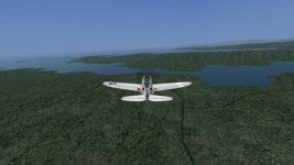
A view of Northwest Spain on the coast. All original CFS3 textures.
 

Attachments

  • north west spain.jpg
    north west spain.jpg
    284.7 KB · Views: 75
Steve are you including the 3 shape files?


shapefile – the name of the .shp file (e.g. vectordata.shp). Shapefiles are actually a set of three files: a .shp file containing the geometry, and .shx file containing indexes into the .shp file, and a .dbf file containing attribute data.


yeah, talking about generating vector mos files. So far I have just tried simple shapefiles for rivers and major_roads (no railroads yet). The combined .mos files are generated with correct prefixes called in theater descriptor. I put them in uncompressed zip file within terrains folder. They just dont show in game.


I always delete .zx files and have tried deleting uisel.xml


I will keep checking my texture lists and bat files for some error .


Thank you
 
Here is another area to look at. How about the theater .xml file. Should like the same but with different entries.

<Terrain OriginLat="N21.03" OriginLon="W156.7" WinterSeason="10,3,5.0,6.0" QuadTreeRootDim="4194304" LandClassField="hawaii.lcf" PreCompiledTexturePrefix="hawaii" WaterPrefix="hawaii" MeshLibrary="hawaiiMeshLibrary.xml" VectorMosaicGridSize="16384" VectorMosaicPrefix="hawaii" LinkedSceneryLinePatternDatabase="hawaii_LinkedSceneryLinePatterns.xml" MeshBuilderBudgets="hawaii_MeshBuilderBudgets.xml" PreCompiledTextureBudget="PreCompiledTextureBudgets.xml" SceneryObjectDatabase="hawaii_SceneryObjects.xml" VectorDataLiningDatabase="hawaii_VectorDataLinings.xml"/>
 
rbp71854,

yeah , all 3 file formats are in the folder.

The ai pathing vector files dont affect the vector mos files do they?
 
Steve I not sure they do, but how would the mos files be placed in the theater without them? I always ran them all together as one process then placed them in the Hawaii theater at the same time.

It can be so frustrating sometimes, the process is so unforgiving to less than perfection. There are times when I am scratching my head for days trying to get something accomplished:banghead:. WE will get there one way or the other.
cheers
Bob


rbp71854,

yeah , all 3 file formats are in the folder.

The ai pathing vector files dont affect the vector mos files do they?
 
It can be so frustrating sometimes, the process is so unforgiving to less than perfection. There are times when I am scratching my head for days trying to get something accomplished:banghead:. WE will get there one way or the other.
cheers
Bob

thanks Bob. I believe I have it working. Had to change tp2mos x and y bounds to default theater size even though I am making a smaller theater :mixed-smiley-010:
 
thanks Bob. I believe I have it working. Had to change tp2mos x and y bounds to default theater size even though I am making a smaller theater :mixed-smiley-010:

That's great news!:applause:

When you say default theater size do you mean 1835km? If so, that's a great heads up as my theater size for PNG is going to be 1792km.
 
When you say default theater size do you mean 1835km? If so, that's a great heads up as my theater size for PNG is going to be 1792km.

I'm using the extents from your Hawaii example


tp2mos hawaii_river.tp hawaii_tex.cfg N21.03 W156.7 -786432 -786432 786432 786432 16384 hawaii_vectorriver 0.05 vectordetailtexture.dds
 
30 arc vs 3 arc

Had a few minutes earlier today and ran two *.bil files. One with 3 arc and the other with 30 arc. The 3 arc has a pixel size of 19200, the 30 a pixel of 1920. The 3 arc takes hours to process while the 30 takes seconds. I did this since the Norway/Artic Convoy theater I want to make, I can only find 30 arc data. Has anyone found 3 arc? I am using earth explorer from the USGS site. I would think if they don't have it no one will..... well may need to look at the European Space Agencey site.....

Also, something has been gnawing at me, with a pixel size of 1920 for the bil file, you need an image stride of 768 to give you a dimension in meters of about 1440 km (which is the approximate size of my theater). What does all this mean. If image stride controls detail, a smaller stride would maybe reveal greater detail. But, with a bil with a pixel count of 19200 your image stride would be small than 256 pixel figure on a factor of 10. My question is does any of this matter? It does when you begin making the tiff files and the .msh files. Original CFS3 had about 3100 msh files. This is with a 6 factor in the code to generate the msh. Increasing this number exponentially increases the number of .msh files. So what to do? Not sure at all. I imagine that the clarity and detail of the terrain is impacted by these data. Flat coastal areas may not be impacted that much, but terrain with hills, cliffs, and such might. I am going to experiment a bit to see what happens by altering some of these parameters.

Any comments welcome....
 
Interesting Ted, I believe you are in an area that few have ventured before. Your results will be interesting to hear.

I have looked and have found no 3 arc data. Sorry. It looks like the Shuttle didn't or couldn't capture that data. I imagine the government has the data but may be withholding for some reason.
 
I'm not familiar with the terrain data file format, but if it can be turned into graphics data I have a copy of Gigapixel AI that can upscale it to a higher resolution.
 
Ok I have too much time to think....

Drove to Baltimore on Wednesday and had some time to think in traffic and such....When are they every going to finish the road work around DC???

We have been told to make our terrains square, by selecting a perfectly square region for our terrain data source. Ok, I get that as the LCF in the original game is 1536 x 1536 when you view it with Martain Wright's viewer and save the image. When you look at the mission builder map you get an image of 1876 x 1844 ok square enough, I guess. Well, that is not the issue I have been pondering for a few days (I really need to drive shorter distances). When you look at the MB map and go to the corners of the map don't ask me why I did this you get approximately 55.3.15N and 7.3.30W for the top left corner and 41.0.2N and 14.5.7E for the bottom right. This means the bottom left is 41.0.2N by 7.3.30W and the top right 55.3.15N and 14.5.7E. Place these dandy coordinates into a longitude/latitude distance calculator and at the top you get a top width of 1336.2km and at the bottom 1777.6, and a height of 1590km. Ok I am a statistician and who know the saying - statistics don't lie but statisticians do. Call me crazy but the original CFS3 dimensions are not square at all. We have a N/S degree span of about 14 degrees and a E/W of about 21 degrees. And yes, the distances are dependent on location so the km measures will vary as you use different coordinates. But that aside what did they do?

I used the data here on the ARC 30 maps and the pixels are of course not square. You could then make it square of course by reducing the dimensions say E/W (in kms) to get a square. Now this is not as crazy as it sounds as we all know a projection maps distort the land masses greatly the further you move N/S. If there is a way to resize the bil file to become a square you reduce the E/W distortion and make a square LCF and MB map. We could use the original CFS3 dimensions as a guide and see what we can do. Now I have no idea how to resize a bil file yet. Why is all of this important, the locations of objects are affected, and the distances traveled when you use a projection map - things are just not right and maybe that is why MS resized the maps. Of course, this really is less important the smaller your theater is. Also, I imagine that with a projection map your mountains and rivers are distorted too causing your terrain to look odd.

Enough of me pondering the inner workings of map dimensions and such. If anyone cares to wade in on this conversation I would appreciate it. I did run this by a novice and she seemed to understand the issue as she said oh the aspect ratios are not consistent....out of the mouth a babes. Have a great day. :banghead:
 
Oh my, I don't think I will wade into that.

Have you noticed that as you approach the edges of the theater, your ac will just freeze before getting to the very edge of the theater? You can have an airfield but you will never takeoff from it.:biggrin-new:
 
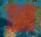
take a look at this for a second

The image is the original cfs3 map on USGS earth explorer. Here is the rub, the box is essentially square in physical dimensions (km side length) but degrees it has approximately 14 degrees latitude range and 21 degrees longitude range but appears square as measured in distance along the x/y axis (thank you Mercator projection I think). Pixel size will be vastly different, but the map will be square in km. Now the question is what to do. The limits of map size are in km 1860 according to the information we have, not degrees. Not that any of this makes anything more clear, but thought I toss it out. Oh, the original LCF is 1536 by 1536 which is a factor of 256. Now, I will use ARC 30 data since it is must easier to process, to experiment.
 

Attachments

  • Clipboard_03-15-2024_01.jpg
    Clipboard_03-15-2024_01.jpg
    67.7 KB · Views: 38
[h=2][/h]
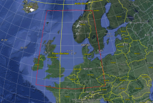
So, projecting on G Earth, one could approximate this from approx the Swiss German boarder, and Brittany, all of the UK, up to approx N63° and E15° Below very rough idea!


North Theatre.png

[h=2][/h]
 
Google Earth

That is way too large in latitudes. A Mercator map really distorts E/W and some N/S, more of course more the closer you get the poles. I have found a way to resize the bil file but ran out of time to see if it will work as I want. I did make an original CFS3 theater using the lat/long from mission builder. I resized the files with what I have learned and they are drop dead the same as the originals. MS did not use a square map from the USGS data but did some type of manipulation to get the square we are being told we need. When you resize the files as MS must have, the E/W distortion all but goes away. If I can figure out how to resize the files and they are still useful (programs run) then I will share my steps.
 
Back
Top