ODG WSL Project - Water Start Locations
Hi Folks
If interested -
Now might be a good time to resurrect a 'community project' I'd previously been working on.
As you've discovered -
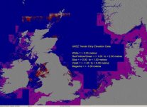
FSX default mesh is dirty,
containing a large number of elevation anomalies,
particularly that in the SP2 release
which no longer flattens the relevant offshore areas.
HTH
ATB
Paul
Hi Folks
Milton -If you know of other great water ports outside the USA especially, please add to this list.
If interested -
Now might be a good time to resurrect a 'community project' I'd previously been working on.
? Anyone ?Out of the box,
FS9/X/P3D provides 574 water airports globally,
with -
- 568 in the USA.
- 5 in the Caribbean.
- 1 in Germany.
That's it !
Very few of which are suitable
as 'Water Start Locations' for pilotable ships/vessels.
I'm looking for assistance with an ODG spin-off project -
Creating 'Water Start Locations' for pilotable ships/vessels, (or amphibious aircraft).
I'll supply a single Google Earth KML file,
containing a set of sub-folders.
There's one sub-folder per Port/Harbour,
with each sub-folder containing a pair of associated placemarks.
At this stage,
all I'm asking is that you .....
relocate pairs of placemarks to suitable IRL locations,
take and record 4 measurements,
then save and return their sub-folder to me.
I'd then import your returned data,
and generate their AFD BGLs.
The catch is.....
for phase 1, ODG WSL - 'World Ports Index' Series,
there's 4,041 pairs of placemarks worldwide.
Hence my request for assistance. ;-)
If we ever complete that,
and can drum up sufficient interest......
There's potentially a further 14,000
covering the outstanding sea, river, & inland water ports.
Those'd be spread across multiple 'phased releases'.
All 18,000 have already been assigned unique 'Airport Identifiers'.
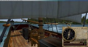
Interesting; in my two years of sailing and testing in FS9 and FSX, I have never experienced running aground in the sea but then I have default scenery.
I don't know if these lines are always there because you don't actually see them until you're close.. they seem to appear from nowhere.
As you've discovered -
FSX default mesh is dirty,
containing a large number of elevation anomalies,
particularly that in the SP2 release
which no longer flattens the relevant offshore areas.
HTH
ATB
Paul