• There seems to be an uptick in Political comments in recent months. Those of us who are long time members of the site know that Political and Religious content has been banned for years. Nothing has changed. Please leave all political and religious comments out of the forums.

    If you recently joined the forums you were not presented with this restriction in the terms of service. This was due to a conversion error when we went from vBulletin to Xenforo. We have updated our terms of service to reflect these corrections.

    Please note any post refering to a politician will be considered political even if it is intended to be humor. Our experience is these topics have a way of dividing the forums and causing deep resentment among members. It is a poison to the community. We appreciate compliance with the rules.

    The Staff of SOH

  • Server side Maintenance is done. We still have an update to the forum software to run but that one will have to wait for a better time.

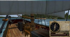
HMS Bounty for FSX Released

ODG WSL Project - Water Start Locations

Hi Folks

If you know of other great water ports outside the USA especially, please add to this list.
Milton -
If interested -
Now might be a good time to resurrect a 'community project' I'd previously been working on.

Out of the box,
FS9/X/P3D provides 574 water airports globally,
with -
- 568 in the USA.
- 5 in the Caribbean.
- 1 in Germany.

That's it !

Very few of which are suitable
as 'Water Start Locations' for pilotable ships/vessels.


I'm looking for assistance with an ODG spin-off project -
Creating 'Water Start Locations' for pilotable ships/vessels, (or amphibious aircraft).


I'll supply a single Google Earth KML file,
containing a set of sub-folders.

There's one sub-folder per Port/Harbour,
with each sub-folder containing a pair of associated placemarks.

At this stage,
all I'm asking is that you .....
relocate pairs of placemarks to suitable IRL locations,
take and record 4 measurements,
then save and return their sub-folder to me.

I'd then import your returned data,
and generate their AFD BGLs.

The catch is.....
for phase 1, ODG WSL - 'World Ports Index' Series,
there's 4,041 pairs of placemarks worldwide.

Hence my request for assistance. ;-)


If we ever complete that,
and can drum up sufficient interest......

There's potentially a further 14,000
covering the outstanding sea, river, & inland water ports.
Those'd be spread across multiple 'phased releases'.

All 18,000 have already been assigned unique 'Airport Identifiers'.
? Anyone ?


Interesting; in my two years of sailing and testing in FS9 and FSX, I have never experienced running aground in the sea but then I have default scenery.

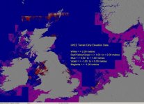
I don't know if these lines are always there because you don't actually see them until you're close.. they seem to appear from nowhere.

As you've discovered -
FSX default mesh is dirty,
containing a large number of elevation anomalies,
particularly that in the SP2 release
which no longer flattens the relevant offshore areas.


HTH
ATB
Paul
 

Attachments

  • FSX_Terrain_Incorrect_Elevations.jpg
    FSX_Terrain_Incorrect_Elevations.jpg
    89.3 KB · Views: 1
Hi Milton:wavey:

I don't want to labour the point but this is what happens. I don't know if these lines are always there because you don't actually see them until you're close.. they seem to appear from nowhere..

I believe... this is a default quirk of FSX from the very first release. Any time there is an elevation change in water and if it reaches a certain angle, then FSX applies a slope texture to the area. After FSX's release there was a revised Terrain.cfg file made up by a couple of smart people that fixes this issue and some other "quirks".

Highly recommended to get the update/revised file by Luis Feliz-Tirado and Dick Ludowise, but if there have been changes to your existing Terrain.cfg file there will need to be some cutting and pasting done to keep things in line.

If anyone wants to go down that path, start a new thread so as to not distract from Milton's and crew release and I'll try to explain the process.
 
Ahh.. thanks for that Paul. I was always under the impression it was a GenX 'thing'. Quite disappointed to find it's 'built in':(

EDIT: RGr that Meshman. I may have tried these in a previous FSX install and while some aspects of it worked ok.. there was a trade off.. isn't there always. Must look at that again;)

ATB
DaveB:)
 
Hi Folks

I believe... this is a default quirk of FSX from the very first release. Any time there is an elevation change in water and if it reaches a certain angle, then FSX applies a slope texture to the area. After FSX's release there was a revised Terrain.cfg file made up by a couple of smart people that fixes this issue and some other "quirks".

Highly recommended to get the update/revised file by Luis Feliz-Tirado and Dick Ludowise, but if there have been changes to your existing Terrain.cfg file there will need to be some cutting and pasting done to keep things in line.

If anyone wants to go down that path, start a new thread so as to not distract from Milton's and crew release and I'll try to explain the process.
Lance -
Luis & Dick's modified Terrain.cfg only fixes the visual aspect,
by inhibiting the slope-related texture call.

Applying their modified Terrain.cfg only hides the visuals
and does not address the literally underlying issue
of flattening these mesh discrepancies.

Just to clarify -
The waterslope issue was present in FSX RTM,
though not as extensively as previous SP2 screenie shows.

In SP2 the waterpolys in 'Irish Sea' and 'Southern North Sea'
no longer flattened these mesh anomalies, as they'd previously done in RTM & SP1.
Bugged in SP2 beta.

Above had a major impact on converting our ODG sceneries to FSX compatibility,
as platform models had all been compiled as AGL,
resulting in mismatching pad-harden elevations.


HTH
ATB
Paul
 
Paul,

That sounds like a rather ambitious, yet rewarding project. Yes, please point us to another thread where folks can sign up to help out.

Thanks for the explanations; very helpful.

Regards
 
Yes, there is; interesting history on that movie. I posted a link to that history on the last page of the Bounty Manual. :)

Folks, please read the manual. :)

EDIT: There were actually five movies:

Films
The Mutiny of the Bounty (1916 silent) In the Wake of the Bounty (1933) Mutiny on the Bounty (1935) Mutiny on the Bounty (1962) The Bounty (1984)

See other links here: http://en.wikipedia.org/wiki/HMS_Bounty

I read the info on the last page of your manual - and all the other 17 pages.
I didn't realize there were 5 movies made of the Bounty. I didn't see anything about what version the sound bytes came from other then an interesting overview mentioned in the PDF so, I assumed
that they must of came from the 1935 version (I didn't see it or for that matter any version) - so that is why I asked. :adoration:
I wanted to see the movie from where the sound bytes used came from - thanks :encouragement:

Those sounds came from the 1984 movie, "The Bounty" starring Anthony Hopkins and Mel Gibson. It's a great movie.
 
Did the helmsman ever become a part of the views in the final release? (FSX version)

If anyone is interested I made a camera definition for the helsman:

[CameraDefinition.6]
Title = "Helmsman"
Guid = {F8B3AFB2-A556-4a8b-8470-1EC3DB2FB90F}
Description = Looking at Helmsman
Origin = Center
SnapPbhAdjust = Swivel
SnapPbhReturn = FALSE
PanPbhAdjust = Swivel
PanPbhReturn = FALSE
Track = None
ShowAxis = FALSE
AllowZoom = TRUE
InitialZoom = 0.3
ShowWeather = Yes
InitialXyz = 2.9, 4.8, -17.0
InitialPbh = 0, 0.0, 220
XyzAdjust = TRUE
Category=Aircraft
MomentumEffect=TRUE
ClipMode=Minimum

The camera definition number depends on what is your next camera definition. I have also added port and starboard cameras definitions above. Adjust the numbers so that they are in sequence.
 

Attachments

  • helmsman.jpg
    helmsman.jpg
    63.7 KB · Views: 0
I was just on TeamSpeak with Pops0 who was testing the Bounty package in Steam for me. Great news! Everything works just as it should. :)

So, if you have Steam version, feel free to copy the package over and try it out there. :jump:
 
Did you try Oslo? It's a nice and picturesque passage up through Oslofjord. :)

No, but I will :)

In FSX there is only one water port in Europe, and that is in Germany (per Paul's post). Shame really with all the great seas and rivers in the area.
 
Maybe I'm' missing the definition of water port, but I could think of many just here in Denmark off the top of my head:

Esbjerg and Hanstholm on the west coast, down through Skagerrak to Aalborg through Limfjorden, then Aarhus and Vejle on the east coast of Jutland, Svendborg on the south end of Fyn, Kalundborg on the west coast of Sjaelland, then round through Oeresund to Copenhagen, and finish with Roenne on Bornholm in the Baltic Sea ... :)

(Lol, that actually became more of a sailing trip to Danish cities ...).

(And I'm not quite sure if Bounty can pass below the Svendborgsund bridge ...).
 
Back
Top