• There seems to be an up tick in Political commentary in recent months. Those of us who are long time members of the site we know that Political and Religious content has been banned for years. Nothing has changed. Please leave all political and religiours commentary out of the fourms.

    If you recently joined the forums you were not presented with this restriction in the terms of service. This was due to a conversion error when we went from vBulletin to Xenforo. We have updated our terms of service to reflect these corrections.

    Please note any post refering to a politicion will be considered political even if it is intended to be humor. Our experience is these topics have a way of dividing the forums and causing deep resentment amoung members. It is a poison to the community. We apprciate compliance with the rules.

    The Staff of SOH

  • Server side Maintenance is done. We still have an update to the forum software to run but that one will have to wait for a better time.

NAS Alameda, CA KNGZ for FSX

Belay my last

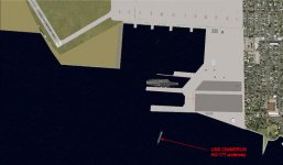
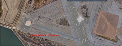
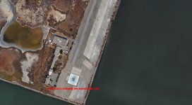
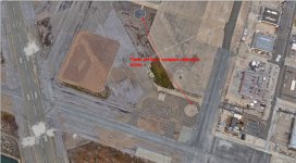
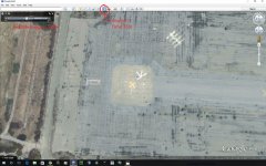
Looks like the location of the beacon in the scenery is not far from what is indicated (red circle) on diagram. Star= beacon

Alameda_NAS_KNGZ_Diagram.jpg


Just got the Diagram and TACAN chart from Woogey's MAIW thread. Thanks Woogey.

Richard
 
Thanks DaveB and Richard for the compliments. If you right click on my pic you can choose to set as background (ie: desktop) directly from here. I have it as MY desktop background. I had been to Alameda for years. This day of test flying I took a break (2 hour nap-hehe) and came back to see the sun low with SF skyline and Oakland Bay Bridge in silouette. Just HAD to capture the scene (before it changes to 6 story apartments and Strip Malls).
Chuck B
Napamule
 
Got To fly Today

I had trouble with FSX for quite a while today but finally got to fly. The COD was giving me trouble (gotta work on it tomorrow) so I flew my DC-3 from Alameda to Fresno where the others of my family live. If I had thought of linking to Google Earth I coulda seen their house as I came in at 29L. It was really great with all the ATC on VATSIM. I flew VFR, beautiful weather this afternoon, and checked in with Oakland Center requesting flight following. Then handed off to Norcal Approach who kept me up to date with altimeter settings and finally handed off to Fresno Approach, called it in downwind midfield, clearance to land and a nice smooth touchdown. 59 minutes in the air off the blocks to on the blocks with the tail wind.

Gonna update my logbook now and say goodnight. I will continue across the estuary tomorrow afternoon starting to place the warehouses for the Navy Supply Center on the point. I replaced the old runways that I had plotted with taxiways that never wanted to work for me with concrete aprons and all the vehicle paths with vector roads. I downloaded traffic signs/lights and gonna see how I can place them where they are supposed to go from what photos of the base I was able to get. BTW, Preston, do you have any real good pdf's of the airport chart and TACAN approach or are they from jpgs. Would like to add them into the downloads folders for everyone since it seems National Archives can't be bothered to reply to my two requests for the airport charts from them (They DO have them). See ya all tomorrow.

Richard
 
Here is my first attempt at AI ship

I downloaded a great tutorial from RTMM for ai water traffic. After about a couple hours of why don't its... I managed to get the USS CIMERRON, AO-177 to shop up where it belonged. Heads up: Delete all FS9 AI traffic files from your world scenery and Addon scenery and put the textures into the Scenery/World/Texture. The 3 files were compiled in the AI Boat Traffic Compiler. I just downloaded the CCP over at FSX@War and will play with that tomorrow.
attachment.php
attachment.php
 

Attachments

  • Image_160418_193455.jpg
    Image_160418_193455.jpg
    73.3 KB · Views: 2
  • Image_160418_205135.jpg
    Image_160418_205135.jpg
    36.5 KB · Views: 2
Helo Pads

According to info I located, there were 2 helo pads on the base somewhere. I think that I have located on Google Earth where they were. Here are photos of the two helo pads where I intend to locate them in V3.0 and also the 2 compass calibration circles. LMK if that looks logical to you. Always welcome input from anybody who served at Alameda who has a better idea of the locations of these.
attachment.php


attachment.php


attachment.php
 

Attachments

  • Image_160419_000655.jpg
    Image_160419_000655.jpg
    73.1 KB · Views: 2
  • Image_160419_000921.jpg
    Image_160419_000921.jpg
    74.4 KB · Views: 2
  • Image_160419_000801.jpg
    Image_160419_000801.jpg
    107.4 KB · Views: 2
According to info I located, there were 2 helo pads on the base somewhere. I think that I have located on Google Earth where they were. Here are photos of the two helo pads where I intend to locate them in V3.0 and also the 2 compass calibration circles. LMK if that looks logical to you. Always welcome input from anybody who served at Alameda who has a better idea of the locations of these.
attachment.php


attachment.php


attachment.php

Your second picture is correct on the Helo pad. The rest are not though. There were actually 6 Helo pads. Check my attachment. They are marked with an "H". The two most commonly used though we're at the West end of taxiway F, and the west end of taxiway H.
 

Attachments

  • image.jpg
    image.jpg
    27.7 KB · Views: 2
Taxiway "H" Helo Pad

attachment.php


This is an early version of my Taxiway H Pad, it has been refined a bit since this photo was taken last week.

-Woog
 

Attachments

  • image.jpg
    image.jpg
    69.8 KB · Views: 4
Helo pads

Hey Woog,

Thanks for that. I haven't put anything down yet and will follow that info. Appreciate the pics as well. I haven't seen those markings in the stock helo pads so I will probably have to put blank ones and mark with poly artwork. Good timing on the reply.

UPDATE: After much research this A.M. online, the Navy USMC show the standard VFR helipad marking is the H in a Square at NAS's and is 60 ft x 60 ft according to construction docs. Not saying you're wrong. I tried to enlarge all the prior 1993 photos but could not see any of them clearly and 2015's Google Earth is two obliterated to see what they were anymore.

R
 
Last edited:
The Helipads

After the above post, I did a Google search for USN/USMC Helicopter Pad Markings and "lo and behold" I came across this DOD Directive released as AFMAN 32-1123 which has everything we ever wanted to know about 1999 and I am sure our period DOD airfields and heliports and a whole lot more. For Woogey, gray eagle, me and all the rest following this thread, here it is for your library. Dropbox link below, it was too large for the forum upload of a PDF.

https://www.dropbox.com/s/h1i3y8zwmty2lke/afman32-1123.pdf?dl=0

Once I place the 6 helopads where they are shown on the Airport Diagram...(I have been using this to fly, why didn't I consult it...DUH!!! LOL) I am going to revise the parking according to the directive (which is I am sure how it was laid out) in Version 3.0 of my NAS Alameda before I considered it a finished, usable download.

Hi Ho, Hi Ho its off to ADE I go! All 6 helipads are now on V3.0 as are some of the warehouses and all the railroad spurs.

R
 
Last edited:
Yeah the way I have marked this is from some photos I had found, can't remember where. Might have been Google Earth actually, when I used the time tool to wind back the clock. Basically, they had this pad marked up for practice approaches to Navy Frigates and Destroyers. The Helo equivalent of a FCLP.

-Woog
 
FCLP Pad

Yeah the way I have marked this is from some photos I had found, can't remember where. Might have been Google Earth actually, when I used the time tool to wind back the clock. Basically, they had this pad marked up for practice approaches to Navy Frigates and Destroyers. The Helo equivalent of a FCLP.

-Woog

How did you do that??? I need to learn some design software to custom make the pad as scenery. I also want to custom design the gatehouse and a few other buldings but that is in the future. thanks for the help.
I could'nt see markings on Google, will look again. I have placed all 6 pads where they are supposed to be from the airport diagram but all "H" standards for now.
 
Really looking forward to this latest version . I love to fly around the bay (in FSX SE) . I do have FTX Global and Vector running and NAS Alameda was a favorite spot to do a few T & G's especially late evening .

Rich
 
You are MOST welcome

Really looking forward to this latest version . I love to fly around the bay (in FSX SE) . I do have FTX Global and Vector running and NAS Alameda was a favorite spot to do a few T & G's especially late evening .

Rich

Thank you for taking the time to comment here. When I started working on this back in March there were only a couple guys (who have been my faithful few throughout) who said that they would be interested, but to see how many downloads and especially how many visits (over 6500) is just overwhelming. I have gotten so much here and from FSDevelopers, AVSIM, Flightsim, FS2000 and Simviation not to mention Blue Sky Scenery that to be able to give back to the community is what really makes all the late hours so worth while.

When I was much younger I loved to build plastic airplane models (really put together, painted and decalled-not snap kits) and I still have the books I had for reference and a lot more accumulated over the years. Now I do my creative work in FSX repainting and now scenery (just a novice there but learning as I go) creation. I am finishing redoing the parking and it will be posted probably Friday. Watch here for the link. :wavey:
 
Google Date Tool

How did you do that??? I need to learn some design software to custom make the pad as scenery. I also want to custom design the gatehouse and a few other buldings but that is in the future. thanks for the help.
I could'nt see markings on Google, will look again. I have placed all 6 pads where they are supposed to be from the airport diagram but all "H" standards for now.

attachment.php


Hey Richard, while in Google Earth, if you click the button that looks like a clock with a green arrow pointing counter clockwise, it will bring up the time slider. Then you just scroll through the imagery they have until you find the clearest available.

-Preston
 

Attachments

  • Old Google Imagery.jpg
    Old Google Imagery.jpg
    75.6 KB · Views: 4
Google Time Travel

attachment.php


Hey Richard, while in Google Earth, if you click the button that looks like a clock with a green arrow pointing counter clockwise, it will bring up the time slider. Then you just scroll through the imagery they have until you find the clearest available.

-Preston

Thanks for this. I know of the "clock" and have been using the 1993 photo though it is B/W. This must be the 2003 photo that I also saw but the air station was already deteriorating so I didn't stay there. How did you create the pad in your air station? I think that this looks like Helo Pad #4 on the Airport chart to me what do you think?

Richard
 
The ORBX Version

Hey Guys, just wanted to post a couple of shots of My ORBX version.

attachment.php
attachment.php
attachment.php
 

Attachments

  • 2016-4-21_11-25-26-451.jpg
    2016-4-21_11-25-26-451.jpg
    71.3 KB · Views: 3
  • 2016-4-21_11-25-42-574.jpg
    2016-4-21_11-25-42-574.jpg
    69.9 KB · Views: 3
  • 2016-4-21_11-10-14-852.jpg
    2016-4-21_11-10-14-852.jpg
    49.4 KB · Views: 3
Back
Top