• There seems to be an up tick in Political commentary in recent months. Those of us who are long time members of the site we know that Political and Religious content has been banned for years. Nothing has changed. Please leave all political and religiours commentary out of the fourms.

    If you recently joined the forums you were not presented with this restriction in the terms of service. This was due to a conversion error when we went from vBulletin to Xenforo. We have updated our terms of service to reflect these corrections.

    Please note any post refering to a politicion will be considered political even if it is intended to be humor. Our experience is these topics have a way of dividing the forums and causing deep resentment amoung members. It is a poison to the community. We apprciate compliance with the rules.

    The Staff of SOH

  • Server side Maintenance is done. We still have an update to the forum software to run but that one will have to wait for a better time.

NAS Alameda, CA KNGZ for FSX

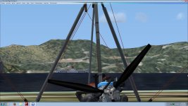
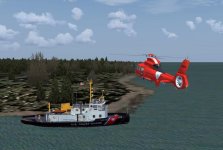
I finally stumbled on the AO 122 and that freighter. I was taking off from runway ??? and as soon as I rotated, there they were. I don't know how I missed them before.
From the looks of things... that oiler is just sitting er... floating in one spot with no particular place to go or does it?

I put all this in perspective to where the carriers were (red arrows)

Now will AO 122 be there all the time in static mode or what?

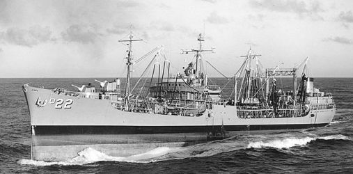
I finally found the USS Cimarron AO 122
oiler.jpg


Red arrows denote where the carriers are from this view
All_Ships.jpg

It seems that the USS Cimerron just kind of rotates around the anchor chain. I guess it "dropped the hook" there. It's not supposed to, it has a Route in Google Earth but though those compile perfectly, like the silly carrier, they don't cruise out to the Pacific like theyre supposed to. I'm going to try and see about that later. Right now I'm putting finishing touches on Version 3.1 I can see from the container ship that is tied up that you are using the static ship version of V3.0 which is why you have 2 carriers. I'll catch ya tommorrow. Sleep well.

Richard
 
Boat Traffic Files

I found that AIBTC (AI Boat Traffic Creator) program and it looks like it wants the source file which I don't have. This gui looks a lot like TTools.
Any way, what I was interested in is looking at the source files so that maybe I could see what kind of journey/path the carrier and the oiler
were programed for.

It looks like I can use the aibtc to decompile your ship traffic files.

Like AI traffic, I was expecting to see the USS Cimarron somewhere out there near Alameda.

One other queston, you included the AI for the Kitty Hawk (CV63) did you use it for a traffic file as well?

TY, :adoration:
Butch

I used the RTMM instructions for the Boat Traffic using the AIBTC to make it all happen after I plotted the course for the oiler and the carrier in Google Earth. They are .kml files as it says to do. I did not use the Kittyhawk but the Constellation because I am using the no static ships version and wanted ai traffic. I increased my slider in FSX and watched another carrier (couldn't get close enough with BOB) to see which one and also an UGARD container ship sailing under the Oakland bridge, Golden Gate Bridge and out to sea from a hill overlooking the San Francisco Bay which I put myself on with "Map". My FSX is broken to slew as I said above so I have to do that but it works with trial and error.
attachment.php


above is the San Francisco ferry, FSX ai boat traffic.
 

Attachments

  • Image_160425_155541.jpg
    Image_160425_155541.jpg
    59.8 KB · Views: 5
Google Earth changed the contents of KML files so they are no longer compatible with FSX AI Boat Traffic compiler. You will have to find the coordinates in FSX (ideally) or Google Earth and create them in the .csv file yourself as shown in the instructions of AIBTC. Stumbled upon this with Coral Sea and lost a good 2 days for no reason.
 
Google Earth changed the contents of KML files so they are no longer compatible with FSX AI Boat Traffic compiler. You will have to find the coordinates in FSX (ideally) or Google Earth and create them in the .csv file yourself as shown in the instructions of AIBTC. Stumbled upon this with Coral Sea and lost a good 2 days for no reason.

That is a rather unwelcome development. It was a bit of work but I only recently managed using ABITC and TTools to get five USN carriers on independent tracks on Yankee Station which together with the Vietnam War Project scenery and follow on AI packages has made SEA ops a real treat. What I did to get two or three tracks to work close together was to keep cloning the xml - using only notepad - and moving the lat/long start and end coordinates with the same small parallel spacing between ships/plane guard. You can then easily swap out the Midway for the Ranger, etc, by editing the boats text file and recompiling in AIBTC. My hope is that I can keep cloning the same track over and over again and position it anywhere new using this method.

Funny I don' t really use AIBT's full traffic planning resources. I prefer to do this manually in TTools and compile the final Traffic file with AIBT.
 
Stupid Google

Thank you for the heads up on that. We would have been going in cirlces chasing our tail...Why do these folks like Microsoft and FSX and now Google and Google Earth...just when something works they mess it up. My business mentor said that change for the sake of change is courting a disaster. Boy this sure is. FS9 had so many great programs paid and free and then along comes FSX that is supposed to be so much greater and so much FS9 is not compatible. Maybe I'm missing something, I changed a year ago and I like FSX but I still liked FS9 better. Just stuck now with nothing being developed for it any more. And then there's P3D...won't even go there. Ya gotta buy a new computer to run that!
 
That is a rather unwelcome development. It was a bit of work but I only recently managed using ABITC and TTools to get five USN carriers on independent tracks on Yankee Station which together with the Vietnam War Project scenery and follow on AI packages has made SEA ops a real treat. What I did to get two or three tracks to work close together was to keep cloning the xml - using only notepad - and moving the lat/long start and end coordinates with the same small parallel spacing between ships/plane guard. You can then easily swap out the Midway for the Ranger, etc, by editing the boats text file and recompiling in AIBTC. My hope is that I can keep cloning the same track over and over again and position it anywhere new using this method.

Funny I don' t really use AIBT's full traffic planning resources. I prefer to do this manually in TTools and compile the final Traffic file with AIBT.
Hi expat,

Will you be making the tracks for your "five USN carriers on independent tracks on Yankee Station" available to others?

Also when you stated "follow on AI packages" in your post are you saying that there are AI package addons that utilize actual AI aircraft instead of the flyable aircraft converted to AI used in the original Vietnam War Project and if so where did you find them?

The flyable FS9 aircraft converted to AI for the Vietnam War Project really impact FPS much more than the military AI aircraft created for the sole purpose of use as AI such as the military AI aircraft that we have created and released at MAIW.

Thanks,
 
Google Earth changed the contents of KML files so they are no longer compatible with FSX AI Boat Traffic compiler. You will have to find the coordinates in FSX (ideally) or Google Earth and create them in the .csv file yourself as shown in the instructions of AIBTC. Stumbled upon this with Coral Sea and lost a good 2 days for no reason.

That's news to me.:suspicion: I have just recently (yesterday morning) used GE to generate .kml files for five ships on the East Coast and Gulf of Mexico (additional USCG NSCs as in my thread "The Other Alameda"). All ships show up, follow the tracks, return as per the Plans. I have also made .bgls for nine USCG Bay Class icebreakers in the Great Lakes. And a sailboat in the Chesapeke Bay.
 
Found the AO 122 again

This session of "Dial up Alameda in FSX", I find the USS Cimarron AO22 heading for the Golden Gate, maybe a deployment? At least it looks like it is on a circuitous route in the SF Bay area.

I was pacing it at about 28~ knots.
GOlden_Gate.jpg
 
Goggle earth KML

After the post about the GE not working, I tried to use csv files like AIBTC says it would but...it wouldn't compile them. I then went out searching about KML files. I found a post here at SOH from Alain Silvaine that gave a guy HIS kml route file in a zip and I downloaded it as an example. It is very much simpler than the current GE kml files. I opened it in Notepad++ and edited it replacing HIS lat/long with MY lat/long from my Google Earth plotted tracks. 1. It compiled. 2. It opens perfectly in Google Earth. 3. It works. The ships move and come back. I wonder, Butch are you following an FSX ai tanker or the USS Cimerron AO177. My original RoutesCimmerron.bgl never did any thing but seem to rotate around the anchor.

My AO177 left this morning and then returned later.
 
How many Cimarron's does this have?? I can't keep up:dizzy: 
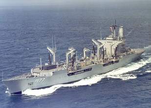
AO-177 Cimarron was launched in 79.. AO-22 is a WWII Cimarron:biggrin-new:
ATB
DaveB:)
 
There wasn't any reference info as to which one it is. I suspect the AO-22 due to the ships profile. The AO-177 looked a bit different.

This is the older version: Commissioned: March 20, 1939 Decommissioned: October 1, 1968

ao22_1.jpg


This is the AO-177 Launched: April 28, 1979 Commissioned: January 10, 1981 Decommissioned: December 15, 1998

ao177_3.jpg
 
What GE version do you have ? ?
I've downloaded GE for three separate systems in the past couple of weeks. All are the same version I use at home - 7.1.5.1557 - dated 5/20/2015.
These are all on machines running Win 7.
 
Small updates to buildings-

While the tower is the main focus of this group of facilities I chose to start on one of the less prominent buildings. Why? So that I won't give up the challenge as soon as the main buildings are done. At this stage I tend to leave measurement guidelines in place to show how many times I measure and verify measurements.

attachment.php
 

Attachments

  • 27April Update_Capture.jpg
    27April Update_Capture.jpg
    79.7 KB · Views: 4
Dynomiiiiiiiiiite!!!

Small updates to buildings-

While the tower is the main focus of this group of facilities I chose to start on one of the less prominent buildings. Why? So that I won't give up the challenge as soon as the main buildings are done. At this stage I tend to leave measurement guidelines in place to show how many times I measure and verify measurements.

attachment.php

This really looks great! Through much effort tonight I managed to finish the Eastgate guardshack from photos including a Marine in Dress Blues saluting from the 3D Warehouse. Windows came from the warehouse too. It only took 3 hours. I am sure that this simple 4-square flatroof building woulda taken a Sketchup pro only a 1/2 hour but hey it's my second attempt at Sketchup. My gate guard aircraft pylons are lookin good at the gates too. I'm not freeloadin' on ya. LOL. Keep up your good work. I saw the Main Gate building complex in the 3D Warehouse. I feel a little confident now to tackle it. Maybe after I do I will be weeping like a girl (LOL) but tonight I'm on Cloud 9. TTYL.

Richard
attachment.php


attachment.php
 

Attachments

  • Image_160427_225902.jpg
    Image_160427_225902.jpg
    16.1 KB · Views: 2
  • Image_160427_225928.jpg
    Image_160427_225928.jpg
    25.6 KB · Views: 2
That's news to me.:suspicion: I have just recently (yesterday morning) used GE to generate .kml files for five ships on the East Coast and Gulf of Mexico (additional USCG NSCs as in my thread "The Other Alameda"). All ships show up, follow the tracks, return as per the Plans. I have also made .bgls for nine USCG Bay Class icebreakers in the Great Lakes. And a sailboat in the Chesapeke Bay.

Are those USCG Ships/Traffic available for Download please? Ive been looking for some Gulf USCG and Great Lakes Traffic.
 
Are those USCG Ships/Traffic available for Download please? Ive been looking for some Gulf USCG and Great Lakes Traffic.

The Bay Class textures and traffic files will be uploaded in a bit. I need to make a few minor corrections to the routes, and am waiting for approval from Hendrik as they are repaints of his model.
The NSC repaints are on the cutter that comes with the payware FS9 Jayhawk from Aerosoft. They will also work with the Aerosoft FSX Seahawk/Jayhawk cutter. I have not had time to figure how to get the FSX NSC to work as AI. The FS9 cutter works fine as AI in FSX. I'm not sure about uploading these as the originals are payware. Stay tuned.
attachment.php


I'll start another thread. Sorry about hijacking in this one.:pirate::sorrow:
 

Attachments

  • screenshot1434c.jpg
    screenshot1434c.jpg
    69.6 KB · Views: 4
None taken...

I'll look forward to watching your thread too. No problem. How else can we all share what we love.

Richard
 
Hey Joe,

I'm liking this. :encouragement: I have the Aerosoft FSX Seahawk/Jayhawk cutter so this should all work out.


The Bay Class textures and traffic files will be uploaded in a bit. I need to make a few minor corrections to the routes, and am waiting for approval from Hendrik as they are repaints of his model.
The NSC repaints are on the cutter that comes with the payware FS9 Jayhawk from Aerosoft. They will also work with the Aerosoft FSX Seahawk/Jayhawk cutter. I have not had time to figure how to get the FSX NSC to work as AI. The FS9 cutter works fine as AI in FSX. I'm not sure about uploading these as the originals are payware. Stay tuned.
attachment.php


I'll start another thread. Sorry about hijacking in this one.:pirate::sorrow:
 
Back
Top