-
Please see the most recent updates in the "Where did the .com name go?" thread. Posts number 16 and 17.
-
IMPORTANT DOWNLOADING INFORMATION - ALL MEMBERS PLEASE READ
Please see this thread for updates. Update Thread
SOH ADMINISTRATION
You are using an out of date browser. It may not display this or other websites correctly.
You should upgrade or use an alternative browser.
You should upgrade or use an alternative browser.
CFS3 Terrain Creation - is anyone still around?
- Thread starter gecko
- Start date
gecko
Charter Member
Here is a related question, but perhaps slightly OT, is there a way to get CFS3 to model the curvature of the earth? I have been playing around with settings for the horizon and have determined conclusively that the CFS3 map is flat. This poses some difficulties when working with the horizon, particularly at high altitude.
As an aside, I had really hoped to be more involved with this, but I am quite impressed with how you guys are running with it! Hopefully I can catch up at some point.
As an aside, I had really hoped to be more involved with this, but I am quite impressed with how you guys are running with it! Hopefully I can catch up at some point.
Curvature of the Earth
From everything that I have read cfs3 only uses a flat earth (hmm seems that the flat earthers were in power at MS). I was told a long time ago that the reason many sims use a flat earth is at the time of their development, to have gunner stations etc., the code was not available to use a curved earth. How true that was (is) who knows. Today and/or tomorrow, I am going to try to duplicate the original cfs3 theater using what I have tinkered with the see what is what (that's a lot of whats).
From everything that I have read cfs3 only uses a flat earth (hmm seems that the flat earthers were in power at MS). I was told a long time ago that the reason many sims use a flat earth is at the time of their development, to have gunner stations etc., the code was not available to use a curved earth. How true that was (is) who knows. Today and/or tomorrow, I am going to try to duplicate the original cfs3 theater using what I have tinkered with the see what is what (that's a lot of whats).
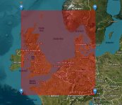
Something like this. The original cfs3 theater was not 1860 km by 1860km. So maybe a little larger, not much.Ah OK. So looking at your projection of the CFS3 map it could be shifted North to the Swiss German border and to just West of Glasgow and Wales? How much of Norway would that get?
Attachments
rbp71854
PTO Solomons ,PTO Rising Sun, ETO Expansion
Just a cautionary tale. With that location/layout you may not be able to fly to Berlin. There is a dead space at some distance from the edges of the theater where the aircraft just freeze. I do not what that distance is as I never measured it while doing RS.
Something like this. The original cfs3 theater was not 1860 km by 1860km. So maybe a little larger, not much.
gecko
Charter Member
And to add to that consideration, my work with the horizon has expanded the distance you can see significantly. I'm presently working with a radius of 150 km for viewing distance which seems to be the max setting for other sims as well. CFS3 is actually capable of much more, but most PC's can't handle it if you add any amount of weather rendered at those distances. The point being, a larger margin around the edges of the map becomes less usable if you don't want to see the rather ugly way CFS3 renders the area off the edge of the map.
hmmm
This may explain that when you go into mission builder you can move well into the green area beyond the borders of the map. I have not tried to see how far this extends but may be explained by the fact the original CFS3 theater is about 1779 km E/W and 1556 N/S and that CFS3 is hard coded to have a useable area of 1860 by 1860 and the original designers choose not to maximize the area for some type of buffer or other considerations. I would really love it if the folks who did this back in the day were around, just for a few questions.
Idea, it may be that the 1860 by 1860 are the maximum possible km dimensions and are square. The idea of square really may only apply to the pixel units for the LCF (1536 pixels square and the data in the ERS file). The MB maps are barely not square as the high altitude one is about 469 by 461, the medium 938 by 922 and the low is 1876 by 1844. Nothing like going into a rat hole.....
Bam!!!! Revelation - If you select a square area in pixels from a map, the km distance will not be equal N/S and E/W by the nature of the Mercator projection (unless you are right at the equator and your area is small), but by selecting a rectangle and then adjusting for latitude (when altering the projection to a Mercator style Global Mapper lets to pick a latitude as a reference and then resizes the bil file by this which with practice) will yield a square bil in pixels. This is what MS did. Now just to duplicate this and to get it to work.
Enough of this already need to get back to that research paper I was writing (but this is more interesting...)
mongoose
SOH-CM-2026
Something like this. The original cfs3 theater was not 1860 km by 1860km. So maybe a little larger, not much.
I would move it East just skirting Cornwall and Scotland to W 5*45' and North a bit with South part at South to N47*35'. This way more of Norway and more East of Berlin to include more of the old German Eastern border. This allows most TOW ops, Russian convoy ops as well as ops against the pocket battleships in the Fjords. Unfortunately not North enough for Narvik, unless a mini theatre is done for all of Norway; a lot for just a few actions.
rbp71854
PTO Solomons ,PTO Rising Sun, ETO Expansion
Yes, this is how I had to tweak to get my PNG theater at 17920.
Started at N-0.025 W142.5, S-15 E157.75
Many test bils later later:
Ended at N-0.0675 W142.5 S-15 E157.4325
DatasetHeader Begin
Version = "6.0"
Name = "Buka_Bougainville_PNG_SRTM30.ers"
LastUpdated = Thu Mar 14 21:55:56 GMT 2024
DataFile = "Buka_Bougainville_PNG_SRTM30.bil"
DataSetType = ERStorage
DataType = Raster
ByteOrder = LSBFirst
CoordinateSpace Begin
Datum = "WGS84"
Projection = "GEODETIC"
CoordinateType = EN
Rotation = 0:0:0.0
CoordinateSpace End
RasterInfo Begin
CellType = Unsigned16BitInteger
CellInfo Begin
Xdimension = 0.00083328679702562
Ydimension = 0.00083328679702562
CellInfo End
NrOfLines = 17920
NrOfCellsPerLine = 17920
RegistrationCoord Begin
Eastings = 142.50000000000000000
Northings = -0.06750000000000000
RegistrationCoord End
NrOfBands = 1
RasterInfo End
DatasetHeader End
Bam!!!! Revelation - If you select a square area in pixels from a map, the km distance will not be equal N/S and E/W by the nature of the Mercator projection (unless you are right at the equator and your area is small), but by selecting a rectangle and then adjusting for latitude (when altering the projection to a Mercator style Global Mapper lets to pick a latitude as a reference and then resizes the bil file by this which with practice) will yield a square bil in pixels. This is what MS did. Now just to duplicate this and to get it to work.

Finished creating ocean and islands, ready now to start producing some exported files for theater creation.
1800km doesnt go very far in the PTO

Steve
But, if you make a rectangle when selecting the area you want to make and have the short side 1800km, depending where you are on the globe you can make the other side (E/W) longer, say for argument sake 2000km. When you apply the Mercator projection and correct for latitude it will make the map square (if you have the correct aspect ratio to start with) but the area you cover will be the same (in degree coverage and km) and eliminate some of the stretching the Mercator projection introduces. Now as I said all of this depends where you are on the globe, the closer you are to the equator the less distortion. I found a source that shows how much the Mercator projection distorts for a given latitude. GM automatically resizes your maps as a function of latitude when you resize using the Mercator option. Last night I remade the original CFS3 theater (14 degrees N/S and and 21 degrees E/W just like the original) resized and made the msh files. The pixel size is larger than the original CFS3 theater, so resizing the LCF will need to happen.
Need to install and see what happens later today. If all goes well then it is a matter of some math (trig -did I ever tell you that I hate trig) to resize the maps as needed. I had to edit the ers file but it ran as expected. Hopefully I will be able to have success and we can have as close to an 1860 by 1860 theater as possible.
Regardless you are correct 1860 km is not much in the Pacific. But when you model Midway for instance, the distances were not great since the range of the aircraft from the carriers was quite limited, what about 500 mile radius SBD and the Aichi 400 miles? Now flying form Tinian to Japan 2500 km so no joy there.
Update
I replicated the original CFS3 theater.
So all in all a success so far. This showed to my simple mind that we can select non-square maps areas, use GM to make them square, fiddle with the data in the ers files and boom - it works . I need to put this aside for a few days as my paint shop appears to be reopened so I need to finish a few small bits and pieces with some planes.
I replicated the original CFS3 theater.
- I first made a bil file in GM with the original lat/long 55N 7W, 40N 14W. as you see it is not square at all.
- I then opened it up and using the projection feature of GM, click on the wrench icon, I then looked at the options in the top drop down and selected Mercator. In the options box that appears there is an option to enter the original latitude ( may have the name incorrect) I enter 48, since this is the mid-way between 55 and 40.
- Saved a workspace file.
- unloaded all data. Then opened the saved workspace and made new bil. The data in now in meters not degrees.
- Opened up both ers files that were made. Took the data from the first ers file and replaced the data in the new ers and saved. This tells the tools we use form MS that all the dimensions are in degrees. The pixels were not square or the same they were 2536 and 2524, just made then both 2560 in the revised ers file. I figured that this slight difference would not matter in a test.
- Made the msh files using the data from the spread sheet, I chose 6 by 6 to make 36 tiff files. This yielded me the same exact number of msh files MS had.
- Made a new landclass file in photoshop by resizing the 2560 by 2560 from the bmp file we need to make, small resizing if you think about it about a 1% resizing from 2530 to 2560 and 1.4% for the other. We can fix this as we fiddle with the map selection in the first step.
- zipped the files for the msh (keep the original shorelines and water as a test) Fired up the sim and flew in southern France to the coast and reached the shoreline exactly as the map in the game indicated. The elevation is off for the airbases and stuff but to be expected.
So all in all a success so far. This showed to my simple mind that we can select non-square maps areas, use GM to make them square, fiddle with the data in the ers files and boom - it works
. I need to put this aside for a few days as my paint shop appears to be reopened so I need to finish a few small bits and pieces with some planes.rbp71854
PTO Solomons ,PTO Rising Sun, ETO Expansion
That's good news Ted.
Iam afraid I am encountering difficulties getting valid tiff files. I get the ers2tiff to produce the files but the tiffs are invalid and when run tiff2mesh I get min 0 max 0 . Flat terrain when placed in the theater.
I have to set the elevation of the area not islands to zero elevation otherwise those areas end up with 55,000 meter elevation. Go figure that. Never recall seeing that before.
I need to put it away for a couple of days as my daughter will be here for the weekend for father daughter time.")
Iam afraid I am encountering difficulties getting valid tiff files. I get the ers2tiff to produce the files but the tiffs are invalid and when run tiff2mesh I get min 0 max 0 . Flat terrain when placed in the theater.
I have to set the elevation of the area not islands to zero elevation otherwise those areas end up with 55,000 meter elevation. Go figure that. Never recall seeing that before.
I need to put it away for a couple of days as my daughter will be here for the weekend for father daughter time.
Steve
You making your own landclass file from the bmp images?
You making your own landclass file from the bmp images?
James
The issue you have right now is the arc 3 data stops at the 60th parallel. The Norway theater I want to have will be arc30 - just dedicated to convoys in the North Sea. If I use arc3 data, I can get Lister (Luster) Norway where the Germans had a NJG base and almost all of southern France. Still fiddling around to understand the process.
I would move it East just skirting Cornwall and Scotland to W 5*45' and North a bit with South part at South to N47*35'. This way more of Norway and more East of Berlin to include more of the old German Eastern border. This allows most TOW ops, Russian convoy ops as well as ops against the pocket battleships in the Fjords. Unfortunately not North enough for Narvik, unless a mini theatre is done for all of Norway; a lot for just a few actions.
The issue you have right now is the arc 3 data stops at the 60th parallel. The Norway theater I want to have will be arc30 - just dedicated to convoys in the North Sea. If I use arc3 data, I can get Lister (Luster) Norway where the Germans had a NJG base and almost all of southern France. Still fiddling around to understand the process.
rbp71854
PTO Solomons ,PTO Rising Sun, ETO Expansion
Anybody have a guess on how many mesh files are created? Right now it is taking about 60 seconds to create 2 mesh files. Slow boat to the PNG.
I thinking that if it is about 5,000 files, then I am looking at a 41 hour run time.
or did you reduce your columns and rows in the ers file by a factor of 10, say like 17920 reduced tp 1792.
Steve is there a reason not to use Google Earth for the landclass tiles?
I thinking that if it is about 5,000 files, then I am looking at a 41 hour run time.
or did you reduce your columns and rows in the ers file by a factor of 10, say like 17920 reduced tp 1792.
Steve is there a reason not to use Google Earth for the landclass tiles?
Last edited: